Algeria–Niger border
The Algeria–Niger border is 951 kilometres (591 miles) in length and runs from the tripoint with Mali in the west to the tripoint with Libya in the east.[1]
Description
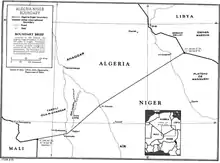
The border consists of three straight lines proceeding northeast between the tripoints with Mali and Libya.[2] The westernmost line runs from the Malian tripoint to the Agadez-Tamanrasset highway for 175 km (109 mi); the middle section run for 229 km (142 mi) up to the vicinity of I-n-Azaoua; and the final and longest segment runs for 552 km (343 mi) up to the Libyan tripoint. The boundary runs entirely within the Sahara desert.
History
The 1880s saw an intense competition between the European powers for territories in Africa, a process known as the Scramble for Africa. The process culminated in the Berlin Conference of 1884, in which the European nations concerned agreed upon their respective territorial claims and the rules of engagements going forward. As a result of this France gained control of the upper valley of the Niger River (roughly equivalent to the areas of modern Mali and Niger).[3] France had already conquered most of northern Algeria during the period 1830-47, incorporating it as an integral part of France.[3] France occupied the area of modern Niger in 1900, declaring it a military territory, ruled originally from Zinder. Niger was originally included, along with modern Mali and Burkina Faso, within the Upper Senegal and Niger colony, however it was split off in 1911 and became a constituent of the federal colony of French West Africa (Afrique occidentale française, abbreviated AOF).[4][3] In the meantime in Algeria France had been pushing south from the littoral region, conquering much of the Algerian Sahara in 1902.[2][3] A boundary between French West Africa and French Algeria (i.e. what are now Algeria’s borders with Mauritania, Mali and Niger) was agreed on 7 June 1905 by the Commandant of Upper Senegal and Niger and the Military Commander of the Department de l'Oasis within French Algeria.[3] The border was further defined by the Niamey Convention of June 1909.[2][3]
As the movement for decolonisation grew in the post-Second World War era, France gradually granted more political rights and representation for their sub-Saharan African colonies, culminating in the granting of broad internal autonomy to French West Africa in 1958 within the framework of the French Community.[5] Eventually, in August 1960, Niger was granted full independence. The situation in Algeria proved much less clear-cut, owing to the large community of French settlers in Algeria, and independence was only granted in July 1962 after a long and bloody war. At that point the Algeria–Niger border became an international frontier between two sovereign states.
In recent years the border region has gained renewed focus, due to increasing numbers of African migrants crossing it seeking to reach Europe; in 2017 Algeria began policing the border more thoroughly, gaining some criticism as deported migrants were stranded at the remote frontier with no provisions.[6][7][8]
Border crossings
The only official border crossing in on the Trans-Sahara Highway between the towns of In Guezzam (Algeria) and Assamakka (Niger).[9] The area is generally deemed unsafe for travel by third party governments.[10][11]
See also
- Algeria-Niger relations
References
- CIA World Factbook - Niger, 3 November 2019
- Brownlie, Ian (1979). African Boundaries: A Legal and Diplomatic Encyclopedia. Institute for International Affairs, Hurst and Co. pp. 85–88.
- International Boundary Study No. 99 – Algeria-Niger Boundary (PDF), 1 May 1970, retrieved 3 November 2019
- Decree 7 September 1911, rattachant le territoire militaire du Niger au gouvernement général de l'Afrique occidentale française, published in the Official Journal of the French Republic on 12 Septembre 1911 (Online)
- Haine, Scott (2000). The History of France (1st ed.). Greenwood Press. p. 183. ISBN 0-313-30328-2.
- Migrant crisis emerges in Sahara Desert on Algeria-Niger border, IOM says, NBC, 16 May 2018, retrieved 8 November 2019
- Hundreds of migrants found abandoned on Algeria-Niger border, Info Migrants, 16 May 2018, retrieved 8 November 2019
- IOM Strengthens Health Capacities at Niger's Borders with Libya and Algeria, IOM, 27 September 2019, retrieved 8 November 2019
- Algeria: Getting there & away, Niger Lonely Planet Guide. Accessed 27 March 2009
- British FCO Travel Advice - Niger, 5 October 2019
- Australian DFAT Travel Advice - Niger, 5 October 2019