Altdöbern
Altdöbern (Lower Sorbian Stara Darbnja) is a municipality in the Oberspreewald-Lausitz district, in southern Brandenburg, Germany.
Altdöbern | |
|---|---|
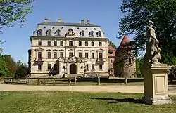 Castle | |
 Coat of arms | |
Location of Altdöbern within Oberspreewald-Lausitz district 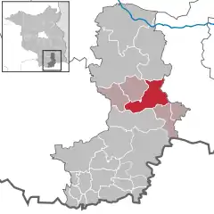 | |
 Altdöbern  Altdöbern | |
| Coordinates: 51°38′59″N 14°01′59″E | |
| Country | Germany |
| State | Brandenburg |
| District | Oberspreewald-Lausitz |
| Municipal assoc. | Amt Altdöbern |
| Subdivisions | 3 Ortsteile |
| Government | |
| • Mayor | Peter Winzer (SPD) |
| Area | |
| • Total | 61.60 km2 (23.78 sq mi) |
| Elevation | 87 m (285 ft) |
| Population (2019-12-31)[1] | |
| • Total | 2,376 |
| • Density | 39/km2 (100/sq mi) |
| Time zone | UTC+01:00 (CET) |
| • Summer (DST) | UTC+02:00 (CEST) |
| Postal codes | 03229 |
| Dialling codes | 035434 |
| Vehicle registration | OSL |
| Website | www.altdoebern.de |
Geography
Altdöbern lies in Lower Lusatia, but is not part of its sorbian inhabited area. The flat landscape is dominated by large forests and new lakes created from the remainings of former opencast lignite mines since the 1990s. One of these is 880 ha (2200 acre) large Altdöberner See, east of the town. Its flooding is planned to be finished in the 2020s.
The municipality of Altdöbern also contains the settlements Pritzen, Peitzendorf and Chransdorf and the villages Ranzow and Reddern.
The municipalities of Altdöbern, Bronkow, Luckaitztal, Neupetershain (Nowe Wiki) and Neu-Seeland together form the collective municipality Amt Altdöbern.
Culture and architecture
The baroque castle of Altdöbern (Schloss Altdöbern) with its surrounding park (Schlosspark) is just northwest of the central market square (Markt). The first castle was built in the 16th century in renaissance style, but later replaced by a new building in baroque architecture including rococo elements. Intense restorations are still in progress, but the interior of the castle can be visited during special events such as the annual park festival (Parksommerträume). The landscape park also contains a small French garden and the large Salzteich lake.
The Protestant church at the market square was built only in 1918–1921, after the medieval predecessor burned in 1914. Other Protestant churches exist in Pritzen and Reddern. A minor catholic church exists at the Waldstraße in Altdöbern.
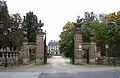 Portal to castle and park
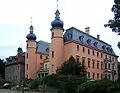 Rear view of Altdöbern Castle
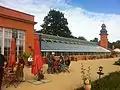 The former orangerie today hosts a café
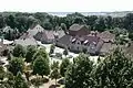 Houses at the market square and the lake in the background
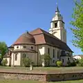 Protestant church
Transport
Via the state road L 53 Altdöbern is connected with Großräschen (B 96) to the south and Calau to the north. Next Autobahn junctions are Freienhufen and Bronkow at A 13 (Berlin–Dresden) and Cottbus-West at A 15 (Berlin–Forst).
Railway stop Haltepunkt Altdöbern gives regional connections to Berlin, Cottbus and Dresden (via Senftenberg).
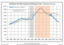
Demography
|
|
References
- "Bevölkerung im Land Brandenburg nach amtsfreien Gemeinden, Ämtern und Gemeinden 31. Dezember 2019". Amt für Statistik Berlin-Brandenburg (in German). July 2020.
- Detailed data sources are to be found in the Wikimedia Commons.Population Projection Brandenburg at Wikimedia Commons
External links
| Wikimedia Commons has media related to Altdöbern. |
- Official site of the municipality of Altdöbern (German)
- Official site of the collective municipality Amt Altdöbern (German)
- Altdöbern Castle at Castles of Brandenburg Administration (English)
Towns and municipalities in Oberspreewald-Lausitz | ||
|---|---|---|
Coat of Arms of Oberspreewald-Lausitz district | ||
| Authority control |
|---|