Großräschen
Großräschen (Sorbian: Rań) is a town in Lower Lusatia, in Germany. Administratively, it is part of the district of Oberspreewald-Lausitz, in the state of Brandenburg.
Großräschen | |
|---|---|
 | |
 Coat of arms | |
Location of Großräschen within Oberspreewald-Lausitz district 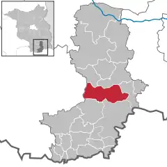 | |
 Großräschen  Großräschen | |
| Coordinates: 51°34′59″N 14°00′00″E | |
| Country | Germany |
| State | Brandenburg |
| District | Oberspreewald-Lausitz |
| Subdivisions | 5 Stadtteile / 7 Ortsteile |
| Government | |
| • Mayor | Thomas Zenker (SPD) |
| Area | |
| • Total | 81.29 km2 (31.39 sq mi) |
| Elevation | 115 m (377 ft) |
| Population (2019-12-31)[1] | |
| • Total | 8,471 |
| • Density | 100/km2 (270/sq mi) |
| Time zone | UTC+01:00 (CET) |
| • Summer (DST) | UTC+02:00 (CEST) |
| Postal codes | 01983 |
| Dialling codes | 035753 |
| Vehicle registration | OSL |
| Website | www.grossraeschen.de |
Geographical position
Großräschen is south of the Niederlausitzer Landrücken, a sandy stretch of land with pine forests in the centre of Lusatia. The source of the small river Rainitza used to be in meadows north of the town centre. South of the town, Lake Ilse (now an open-cast lignite mine) will be completed around 2020. The town proper comprises the historical core, Kleinräschen, and Großräschen. The southernmost quarter, Bückgen, was pulled down due to mining. Outside the town proper are the villages of Freienhufen (historically Dobristroh), Bulldorf, Dörrwalde, Wormlage, Saalhausen, Woschkow, and Schmogro (Großräschen-Ost).
History
Both Großräschen and Kleinräschen were first mentioned in an official document in 1370. The form of settlement and the name suggest that Kleinräschen is older than Großräschen. The villages developed slowly; the Wendish population depended almost entirely on agriculture. From the middle of the 19th century onwards, heavy industry developed, and the villages grew rapidly. In 1965, they were granted the status of a town, having been incorporated into one community in 1925. The 1980s brought the destruction of Bückgen, whose 4000 inhabitants had to leave their homes and were moved into blocks of flats. After the fall of the Berlin Wall, the industrial decline (glass manufacturing, brick production, mining and agriculture used to appear in the town's coat of arms) caused heavy unemployment.
Mayors
Thomas Zenker (SPD) was elected in November 2009 with 93.9% of the votes for a term of eight years. (Turnout 35.3%). He was re-elected in September 2017 with 85.6% for a second term of eight years.[2]
Demography
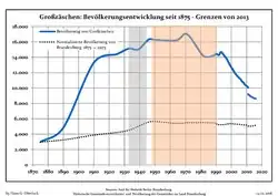 Development of Population since 1875 within the Current Boundaries (Blue Line: Population; Dotted Line: Comparison to Population Development of Brandenburg state; Grey Background: Time of Nazi rule; Red Background: Time of Communist rule)
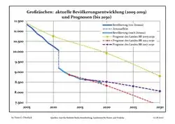 Recent Population Development and Projections (Population Development before Census 2011 (blue line); Recent Population Development according to the Census in Germany in 2011 (blue bordered line); Official projections for 2005-2030 (yellow line); for 2014-2030 (red line); for 2017-2030 (scarlet line)
|
|
|
Sights
- Protestant Church
- Catholic Church with interior decoration by Friedrich Preß
- Medieval village church in Freienhufen
- open-cast mine lookout
- Historic village structures in Kleinräschen, Dörrwalde, Wormlage, Saalhausen (farm type of Senftenberger Vierseitenhof)
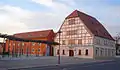 Kurmärker Großräschen, mit Wettigs Hof (13.03.2007)
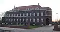 IBA-Geschäftsstelle Großräschen (13.03.2007)
Infrastructure
- Rail links to Berlin, Senftenberg, Stralsund (slow trains)
- Federal road B 96
- Motorway A 13/E 66
Partner cities
 Trzebiatów (Treptow), Poland, since 2006
 Sprockhövel, Germany
- Hattingen, Germany
People
- Herbert Scurla (1905–1981)
- Bernhard Lehmann (born 1948)
- Hans-Joachim Hartnick (born 1955)
References
- "Bevölkerung im Land Brandenburg nach amtsfreien Gemeinden, Ämtern und Gemeinden 31. Dezember 2019". Amt für Statistik Berlin-Brandenburg (in German). July 2020.
- Ergebnis der Bürgermeisterwahl vom 29. November 2009
- Detailed data sources are to be found in the Wikimedia Commons.Population Projection Brandenburg at Wikimedia Commons
External links
- Official website
 (in German)
Towns and municipalities in Oberspreewald-Lausitz | ||
|---|---|---|
Coat of Arms of Oberspreewald-Lausitz district | ||
| Authority control |
|---|