Amargadhi
Amargadhi is a municipality and the district headquarter of Dadeldhura District in Sudurpashchim Pradesh of western Nepal. It was named after Gorkha General Amar Singh Thapa, who fought in the Gurkha War between 1814 and 1816 At the time of the 2011 Nepal census it had a population of 21,245 people living in 4,778 individual households.[1]
Amargadhi
अमरगढी | |
|---|---|
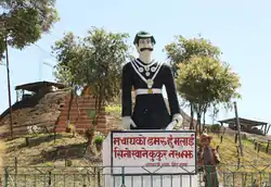 Amar Singh Thapa's statue at Amaragadhi Fort | |
 Amargadhi Location in Nepal | |
| Coordinates: 29°18′00″N 80°34′47″E | |
| Country | |
| Province | Sudurpashchim Pradesh |
| District | Dadeldhura District |
| Incorporated | January 24, 1997 |
| Government | |
| • Mayor | Bisheshwar Prasad Ojha |
| • Deputy Mayor | Sangeeta Bhandari |
| Elevation | 1,848 m (6,063 ft) |
| Population (2011) | |
| • Total | 21,245 |
| Time zone | UTC+5:45 (Nepal Time) |
| Postal code | 10300 |
| Area code(s) | 096 |
| Website | |
Transportation
Mahakali Highway links Amargadhi to the Terai region of Nepal as well as Api Municipality in the Lesser Himalayas. Seti Highway branches off Mahakali Highway at Amargadhi towards Dipayal Silgadhi.[2]
Media
To Promote local culture Amargadhi has three community radio stations, Radio Amargadhi – 97.4 MHz, Radio Sudur Awaz – 95 MHz, and Radio Aafno – 104.8 MHz.
Climate
| Climate data for Amargadhi (1848 m) | |||||||||||||
|---|---|---|---|---|---|---|---|---|---|---|---|---|---|
| Month | Jan | Feb | Mar | Apr | May | Jun | Jul | Aug | Sep | Oct | Nov | Dec | Year |
| Average high °C (°F) | 14.0 (57.2) |
15.2 (59.4) |
19.4 (66.9) |
23.6 (74.5) |
26.1 (79.0) |
26.0 (78.8) |
24.2 (75.6) |
23.8 (74.8) |
23.3 (73.9) |
21.7 (71.1) |
18.5 (65.3) |
15.7 (60.3) |
21.0 (69.7) |
| Daily mean °C (°F) | 9.0 (48.2) |
10.2 (50.4) |
14.0 (57.2) |
18.0 (64.4) |
20.3 (68.5) |
21.3 (70.3) |
20.7 (69.3) |
20.4 (68.7) |
19.4 (66.9) |
16.7 (62.1) |
13.2 (55.8) |
10.5 (50.9) |
16.1 (61.1) |
| Average low °C (°F) | 4.1 (39.4) |
5.1 (41.2) |
8.6 (47.5) |
12.3 (54.1) |
14.5 (58.1) |
16.6 (61.9) |
17.3 (63.1) |
17.1 (62.8) |
15.5 (59.9) |
11.7 (53.1) |
8.0 (46.4) |
5.3 (41.5) |
11.3 (52.4) |
| Average precipitation mm (inches) | 42.8 (1.69) |
62.5 (2.46) |
56.8 (2.24) |
55.1 (2.17) |
92.2 (3.63) |
171.6 (6.76) |
329.2 (12.96) |
315.9 (12.44) |
196.0 (7.72) |
44.3 (1.74) |
9.4 (0.37) |
23.0 (0.91) |
1,398.8 (55.09) |
| Source: http://www.dhm.gov.np/uploads/climatic/880251189NORMAL%20FILE.pdf | |||||||||||||
References
- "National Population and Housing Census 2011" (PDF). Central Bureau of Statistics. November 2017. Archived from the original (PDF) on 27 January 2018. Retrieved 1 October 2018.
- "Existing Highway and Proposed Extension". Department of Roads Nepal. Retrieved 1 October 2018.
External links
Headquarters: Amargadhi | ||
| Municipalities | 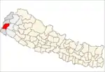 | |
| Rural municipalities | ||
| Former VDCs | ||
List of municipalities and rural municipalities of Nepal | ||
This article is issued from Wikipedia. The text is licensed under Creative Commons - Attribution - Sharealike. Additional terms may apply for the media files.
