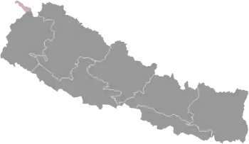
Provinces of Nepal
The Provinces of Nepal (Nepali: नेपालका प्रदेशहरू; Nepālkā Pradeśharū) were formed on 20 September 2015 in accordance with Schedule 4 of the Constitution of Nepal. The seven provinces were formed by grouping the existing districts. The current system of seven provinces replaced an earlier system where Nepal was divided into 14 Administrative Zones which were grouped into five Development Regions.
| Provinces of Nepal नेपालका प्रदेशहरू Nepal ka Pradesh haru | |
|---|---|
 | |
| Category | Federated state |
| Location | Federal Democratic Republic of Nepal |
| Created | 20 September 2015 |
| Number | 7 |
| Populations | Smallest: Karnali, 1,570,418 Largest: Bagmati, 5,529,452 |
| Areas | Smallest: Province No. 2, 9,661 square kilometres (3,730 sq mi) Largest: Karnali, 27,984 square kilometres (10,805 sq mi) |
| Government | Provincial government |
| Subdivisions | Districts |
 |
|---|
| This article is part of a series on the politics and government of Nepal |
|
|
History
A committee was formed to reconstruct the districts of Nepal on 23 December 1956 and after two weeks of duration a report was submitted to government. According to the Nepalko Jilla Prashasan Punargathanko Report, 2013 (A report of reconstruction of districts of Nepal, 1956), Nepal was first time divided into total 7 Kshetras (area).[1] These were the following Kshetras:
- Arun Kshetra
- Janakpur Kshetra
- Kathmandu Kshetra
- Gandak Kshetra
- Kapilavastu Kshetra
- Karnali Kshetra
- Mahakali Kshetra
In 1962, all Kshetras cancelled and the country restructured into 75 development districts and those districts were grouped into 14 zones.[2] In 1972 all 14 zones grouped into 4 development regions, later in 1981 rearranged the zones into 5 following development regions.
- Eastern Development Region
- Central Development Region
- Western Development Region
- Mid-Western Development Region
- Far-Western Development Region
The Provinces of Nepal were formed according to Schedule 4 of the Constitution of Nepal. The Seven provinces were formed by grouping the existing districts; two districts, namely Nawalparasi and Rukum, were split between two provinces. Each district has local units. Nepal includes six metropolises, 11 sub-metropolises, 276 municipal councils and 460 village councils.[3] The current system of seven provinces replaced an earlier system where Nepal was divided into 14 Administrative Zones which were grouped into five Development Regions.
In January 2016 the Government of Nepal announced temporary headquarters of the seven provinces.[4] According to Article 295 (2), the permanent names of the provinces will be determined by a two-thirds vote of the respective province's legislature.
Government
The executive power of the provinces, pursuant to the Constitution and laws, is vested in the Council of Ministers of the province. The executive power of the province shall be exercised by the province Head in case of absence of the province Executive in a State of Emergency or enforcement of the Federal rule. Every province has a ceremonial Head as the representative of the Federal government. The President appoints a Governor for every province. The Governor exercises the rights and duties as to be performed specified in the constitution or laws. The Governor appoints the leader of the parliamentary party with the majority in the Provincial Assembly as the Chief Minister and the Council of Ministers are formed under the chairpersonship of the Chief Minister.
Assemblies
A Pradesh Sabha or Provincial Assembly is the unicameral legislative assembly for a federal province.[5] The term for the Provincial Assembly is five years, except when dissolved earlier.
Candidates for each constituency are chosen by the political parties or stand as independents. Each constituency elects one member under the first past the post system of election. Since Nepal uses a parallel voting system, voters cast another ballot to elect members through the party-list proportional representation. The current constitution specifies that sixty percent of the members should be elected from the first past the post system and forty percent through the party-list proportional representation system. Women should account for one-third of total members elected from each party and if one-third percentage are not elected, the party that fails to ensure so shall have to elect one-third of total number as women through the party-list proportional representation.[6]
A party with an overall majority (more seats than all other parties combined) following an election forms the government. If a party has no outright majority, parties can seek to form coalitions.
List of Provinces of Nepal

| Province | Capital | Governor | Chief Minister | Districts | Area (km²) |
Population (2011) |
Density (people/km²) |
Human Development Index | Map |
|---|---|---|---|---|---|---|---|---|---|
| Province No. 1 | Biratnagar | Somnath Adhikari | Sher Dhan Rai | 14 | 25,905 km² | 4,534,943 | 175 | 0.553 | 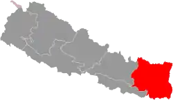 |
| Province No. 2 | Janakpur | Tilak Pariyar | Mohammad Lalbabu Raut | 8 | 9,661 km² | 5,404,145 | 550 | 0.485 | 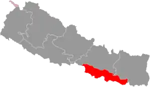 |
| Bagmati Province | Hetauda | Bishnu Prasad Prasain | Dormani Poudel | 13 | 20,300 km² | 5,529,452 | 272 | 0.560 | 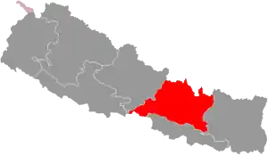 |
| Gandaki Province | Pokhara | Amik Sherchan | Prithvi Subba Gurung | 11 | 21,504 km² | 2,403,757 | 108 | 0.567 | 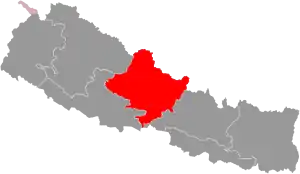 |
| Lumbini Province | Deukhuri | Dharmanath Yadav | Shankar Pokharel | 12 | 22,288 km² | 4,499,272 | 217 | 0.519 | 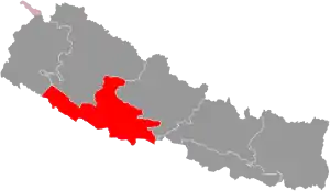 |
| Karnali Province | Birendranagar | Govinda Prasad Kalauni | Mahendra Bahadur Shahi | 10 | 27,984 km² | 1,570,418 | 49 | 0.469 | 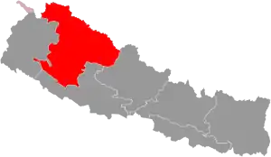 |
| Sudurpashchim Province | Godawari | Sharmila Kumari Panta | Trilochan Bhatta | 9 | 19,915 km² | 2,552,517 | 130 | 0.478 | 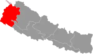 |
| Nepal | Kathmandu | President Bidhya Devi Bhandari |
Prime Minister Khadga Prasad Sharma Oli |
77 | 147,557 km² | 26,494,504 | 180 | 0.579 | |
| Wikimedia Commons has media related to Provinces of Nepal. |
| This article is part of a series on |
| Administrative divisions of Nepal |
|---|
 |
| Federal Democratic Republic of Nepal (Since 2015) |
|
Nepal Portal Administrative divisions by country |
See also
References
- नेपालको जिल्ला प्रशासन पुनर्गठनको रिपोर्ट, २०१३ (PDF).
- "Memorial Step of King Mahendra in 1st Poush 2017 BS". reviewnepal.com. 13 December 2017. Retrieved 6 February 2018.
- Kathmandu Post (2017). "744 new local units come into effect". Kanntipur Publications Pvt. Ltd.
- "Govt fixes temporary state HQs, guvs". Kathmandu: Kathmandu Post. 2018.
- "CA approves ceremonial prez, bicameral legislature". Kanptipur Media Group. 16 September 2015. Retrieved 8 December 2017.
Provincial parliaments will be unicameral. "The CA also approved a mixed electoral system for parliamentary election with 60 percent directly elected and 40 percent proportionally elected."
- "NEPAL: Diluted proportional electoral system". scoop.co.nz. Scoop world. 16 October 2017. Retrieved 8 December 2017.
Nepal articles | ||||||||||||||||||
|---|---|---|---|---|---|---|---|---|---|---|---|---|---|---|---|---|---|---|
| History |
| | ||||||||||||||||
| Geography |
| |||||||||||||||||
| Politics |
| |||||||||||||||||
| Economy | ||||||||||||||||||
| Culture |
| |||||||||||||||||
| ||||||||||||||||||