Amherst, Quebec
Amherst is a township municipality in the Canadian province of Quebec, located within Les Laurentides Regional County Municipality.
Amherst | |
|---|---|
 | |
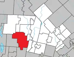 Location within Les Laurentides RCM. | |
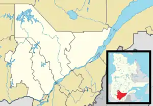 Amherst Location in central Quebec. | |
| Coordinates: 46°03′N 74°46′W[1] | |
| Country | |
| Province | |
| Region | Laurentides |
| RCM | Les Laurentides |
| Constituted | March 9, 1887 |
| Named for | Jeffery Amherst[1] |
| Government | |
| • Mayor | Bernard Lapointe |
| • Federal riding | Laurentides—Labelle |
| • Prov. riding | Labelle |
| Area | |
| • Total | 249.40 km2 (96.29 sq mi) |
| • Land | 231.18 km2 (89.26 sq mi) |
| Population (2011)[3] | |
| • Total | 1,524 |
| • Density | 6.6/km2 (17/sq mi) |
| • Pop 2006-2011 | |
| • Dwellings | 1,608 |
| Time zone | UTC−5 (EST) |
| • Summer (DST) | UTC−4 (EDT) |
| Postal code(s) | J0T 2L0 & J0T 2T0 |
| Area code(s) | 819 |
| Highways | |
| Website | www.municipalite. amherst.qc.ca |
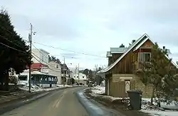
The village of Vendée is also located within the municipality.
Demographics
Population trend:[4]
- Population in 2011: 1524 (2006 to 2011 population change: 7.2%)
- Population in 2006: 1421
- Population in 2001: 1214
- Population in 1996: 1145 (or 1169 when adjusted for 2001 boundaries)
- Population in 1991: 883
Private dwellings occupied by usual residents: 760 (total dwellings: 1608)
Mother tongue:
- English as first language: 0.7%
- French as first language: 97.2%
- English and French as first language: 0%
- Other as first language: 2.1%
Education
Sir Wilfrid Laurier School Board operates English-language schools:
- Arundel Elementary School in Arundel[5]
- Sainte Agathe Academy (for high school only) in Sainte-Agathe-des-Monts[6]
References
- Reference number 1186 of the Commission de toponymie du Québec (in French)
- Geographic code 78070 in the official Répertoire des municipalités (in French)
- "(Code 2478070) Census Profile". 2011 census. Statistics Canada. 2012.
- Statistics Canada: 1996, 2001, 2006, 2011 census
- "Arundel Elementary Zone." Sir Wilfrid Laurier School Board. Retrieved on September 16, 2017.
- "SAINTE AGATHE HIGH SCOOL ZONE" [sic]. Sir Wilfrid Laurier School Board. Retrieved on September 17, 2017 - See text description of boundaries in: About Us" as well as the Elementary zone map - Note that all areas covered in the elementary map are also covered in the secondary one.
Places adjacent to Amherst, Quebec | |
|---|---|
| Cities/towns | |
|---|---|
| Municipalities | |
| Townships | |
| Parishes | |
| Villages | |
| |
This article is issued from Wikipedia. The text is licensed under Creative Commons - Attribution - Sharealike. Additional terms may apply for the media files.