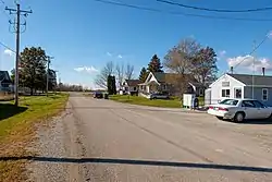
Arispe, Iowa
Arispe is a city in Union County, Iowa, United States. The population was 100 at the 2010 census. It is closely related to the nearby town of Creston.
Arispe, Iowa | |
|---|---|
 | |
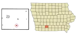 Location of Arispe, Iowa | |
| Coordinates: 40°56′56″N 94°13′8″W | |
| Country | |
| State | |
| County | Union |
| Area | |
| • Total | 0.52 sq mi (1.34 km2) |
| • Land | 0.52 sq mi (1.34 km2) |
| • Water | 0.00 sq mi (0.00 km2) |
| Elevation | 1,270 ft (387 m) |
| Population | |
| • Total | 100 |
| • Estimate (2019)[3] | 97 |
| • Density | 187.62/sq mi (72.44/km2) |
| Time zone | UTC-6 (Central (CST)) |
| • Summer (DST) | UTC-5 (CDT) |
| ZIP code | 50831 |
| Area code(s) | 641 |
| FIPS code | 19-02800 |
| GNIS feature ID | 0454229 |
Geography
Arispe is located at 40°56′56″N 94°13′8″W (40.949010, -94.218974).[4]
According to the United States Census Bureau, the city has a total area of 0.52 square miles (1.35 km2), all land.[5]
Demographics
| Year | Pop. | ±% |
|---|---|---|
| 1910 | 155 | — |
| 1920 | 156 | +0.6% |
| 1930 | 133 | −14.7% |
| 1940 | 149 | +12.0% |
| 1950 | 110 | −26.2% |
| 1960 | 125 | +13.6% |
| 1970 | 93 | −25.6% |
| 1980 | 89 | −4.3% |
| 1990 | 92 | +3.4% |
| 2000 | 89 | −3.3% |
| 2010 | 100 | +12.4% |
| 2019 | 97 | −3.0% |
| Source:"U.S. Census website". United States Census Bureau. Retrieved 2020-03-28. and Iowa Data Center Source: | ||
2010 census
As of the census[2] of 2010, there were 100 people, 42 households, and 32 families residing in the city. The population density was 192.3 inhabitants per square mile (74.2/km2). There were 49 housing units at an average density of 94.2 per square mile (36.4/km2). The racial makeup of the city was 100.0% White.
There were 42 households, of which 35.7% had children under the age of 18 living with them, 57.1% were married couples living together, 11.9% had a female householder with no husband present, 7.1% had a male householder with no wife present, and 23.8% were non-families. 19.0% of all households were made up of individuals, and 11.9% had someone living alone who was 65 years of age or older. The average household size was 2.38 and the average family size was 2.66.
The median age in the city was 41 years. 27% of residents were under the age of 18; 7% were between the ages of 18 and 24; 19% were from 25 to 44; 31% were from 45 to 64; and 16% were 65 years of age or older. The gender makeup of the city was 47.0% male and 53.0% female.
2000 census
As of the census[7] of 2000, there were 89 people, 42 households, and 25 families residing in the city. The population density was 171.6 people per square mile (66.1/km2). There were 44 housing units at an average density of 84.9 per square mile (32.7/km2). The racial makeup of the city was 100.00% White.
There were 42 households, out of which 21.4% had children under the age of 18 living with them, 59.5% were married couples living together, 2.4% had a female householder with no husband present, and 38.1% were non-families. 35.7% of all households were made up of individuals, and 23.8% had someone living alone who was 65 years of age or older. The average household size was 2.12 and the average family size was 2.77.
In the city, the population was spread out, with 19.1% under the age of 18, 3.4% from 18 to 24, 21.3% from 25 to 44, 23.6% from 45 to 64, and 32.6% who were 65 years of age or older. The median age was 49 years. For every 100 females, there were 85.4 males. For every 100 females age 18 and over, there were 94.6 males.
The median income for a household in the city was $25,000, and the median income for a family was $27,917. Males had a median income of $16,250 versus $14,167 for females. The per capita income for the city was $11,999. There were 17.4% of families and 11.7% of the population living below the poverty line, including no under eighteens and 27.6% of those over 64.
Notable person
- Harold R. Gross, member of the United States House of Representatives in the 20th century.
References
- "2019 U.S. Gazetteer Files". United States Census Bureau. Retrieved July 17, 2020.
- "U.S. Census website". United States Census Bureau. Retrieved 2012-05-11.
- "Population and Housing Unit Estimates". United States Census Bureau. May 24, 2020. Retrieved May 27, 2020.
- "US Gazetteer files: 2010, 2000, and 1990". United States Census Bureau. 2011-02-12. Retrieved 2011-04-23.
- "US Gazetteer files 2010". United States Census Bureau. Archived from the original on 2012-01-25. Retrieved 2012-05-11.
- "Census of Population and Housing". Census.gov. Retrieved June 4, 2015.
- "U.S. Census website". United States Census Bureau. Retrieved 2008-01-31.
Municipalities and communities of Union County, Iowa, United States | ||
|---|---|---|
| Cities | Map of Iowa highlighting Union County | |
| CDP | ||
| Unincorporated communities | ||
| Footnotes | ‡This populated place also has portions in an adjacent county or counties | |
| ||