Arizona State Route 89
State Route 89 (SR 89) is a 104.53-mile (168.22 km) state highway in the U.S. state of Arizona. It is part of the former route of U.S. Route 89 (US 89) throughout the state.
| ||||
|---|---|---|---|---|
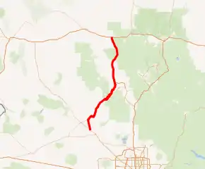
SR 89 highlighted in red | ||||
| Route information | ||||
| Maintained by ADOT, City of Prescott | ||||
| Length | 104.53 mi[1] (168.22 km) | |||
| Existed | 1993 (from U.S. Route 89)–present | |||
| Major junctions | ||||
| South end | ||||
| North end | ||||
| Location | ||||
| Counties | Yavapai | |||
| Highway system | ||||
| ||||

Route description
The southern terminus of SR 89 is located at an intersection with U.S. Route 93 northwest of Wickenburg. It is a largely south-north route; the largest city through which it now passes is Prescott, where it meets SR 69 and the extremely scenic SR 89A. The segment between Prescott and Congress (intersection with SR 71) is quite scenic. The northern terminus of the highway is located at an interchange with Interstate 40 (I-40) in Ash Fork.
History
This highway was a segment of US 89 between Ash Fork at I-40 and US 93 northwest of Wickenburg.
All of US 89 was deleted south of its current southern terminus with Interstate 40 in Flagstaff after interstate highways offered shorter and more direct routes than the old long-distance US 89 in central and southern Arizona in 1993.
Junction list
The entire route is in Yavapai County.
| Location | mi[1] | km | Destinations | Notes | |
|---|---|---|---|---|---|
| | 0.00 | 0.00 | Southern terminus | ||
| Congress | 9.88 | 15.90 | |||
| Prescott | 52.00 | 83.69 | Copper Basin Road / Brookside Boulevard | North end state maintenance | |
| 54.43 | 87.60 | Overland Road – Veterans Cemetery | Right-in/right-out interchange; northbound exit and entrance only; south end state maintenance | ||
| 54.55 | 87.79 | Interchange; no southbound exit | |||
| Gurley Street | Partial interchange; southbound left exit only; northbound access is via Aven Drive intersection | ||||
| 55.86 | 89.90 | Yavpe Connector | North end state maintenance | ||
| N/A | |||||
| 58.13 | 93.55 | Hillsdale Road | South end state maintenance | ||
| 61.09 | 98.31 | Interchange; Pioneer Pkwy. exit 317 | |||
| Ash Fork | 104.53 | 168.22 | Northern terminus; I-40 exit 146; highway continues as I-40 BL west | ||
| 1.000 mi = 1.609 km; 1.000 km = 0.621 mi | |||||
See also
- Drake, Arizona, site of the old Hell Canyon Bridge formerly used by US 89, now on the National Register of Historic Places.
References
- Arizona Department of Transportation. "2008 ADOT Highway Log" (PDF). Retrieved April 9, 2008.
External links
| Wikimedia Commons has media related to Arizona State Route 89. |