Congress, Arizona
Congress is a census-designated place (CDP) in Yavapai County, Arizona, United States. Once a gold-mining center for the Congress Mine and then a ghost town, Congress now serves as a retirement and bedroom community for nearby Wickenburg. The population was 1,717 at the 2000 census.
Congress, Arizona | |
|---|---|
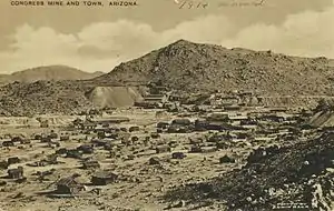 View of Congress and the mine, c.1914. | |
 Location in Yavapai County and the state of Arizona | |
 Congress, Arizona Location in the United States | |
| Coordinates: 34°8′46″N 112°50′48″W | |
| Country | United States |
| State | Arizona |
| County | Yavapai |
| Area | |
| • Total | 37.69 sq mi (97.63 km2) |
| • Land | 37.66 sq mi (97.53 km2) |
| • Water | 0.04 sq mi (0.09 km2) |
| Elevation | 3,045 ft (928 m) |
| Population (2010) | |
| • Total | 4,821 |
| • Estimate (2016)[2] | N/A |
| Time zone | UTC-7 (MST) |
| ZIP code | 85332 |
| Area code(s) | 928 |
| FIPS code | 04-15220 |
| GNIS feature ID | 0003172 |
History
Gold was discovered at the Congress Mine in 1884. By 1893, the Santa Fe, Prescott and Phoenix Railway passed within three miles of the mine, at Congress Junction. Congress boomed, and remained prosperous until the mid-1930s, when the mines closed. Total gold production at the Congress Mine exceeded $8 million, at the then-current price of $20.67 per ounce — or about $400 million, at the 2007 price.[3]
The post office moved to Congress Junction in 1938, where it remains. The community now known as Congress is the old Congress Junction. Little remains at the original townsite.[4]
Geography
Congress is located at 34°8′46″N 112°50′48″W (34.146068, -112.846533).[5]
According to the United States Census Bureau, the CDP has a total area of 37.7 square miles (98 km2), of which, 37.6 square miles (97 km2) is land and 0.04 square miles (0.10 km2) (0.08%) is water.
Climate
According to the Köppen Climate Classification system, Congress has a semi-arid climate, abbreviated "BSk" on climate maps.[6]
Demographics
| Historical population | |||
|---|---|---|---|
| Census | Pop. | %± | |
| U.S. Decennial Census[7] | |||
At the 2000 census,[8] there were 1,717 people, 821 households and 579 families residing in the CDP. The population density was 45.6 per square mile (17.6/km2). There were 1,070 housing units at an average density of 28.4 per square mile (11.0/km2). The racial makeup of the CDP was 95.92% White, 0.52% Native American, 0.06% Asian, 1.81% from other races, and 1.69% from two or more races. 7.98% of the population were Hispanic or Latino of any race.
There were 821 households, of which 12.7% had children under the age of 18 living with them, 63.5% were married couples living together, 4.0% had a female householder with no husband present, and 29.4% were non-families. 24.5% of all households were made up of individuals, and 13.9% had someone living alone who was 65 years of age or older. The average household size was 2.09 and the average family size was 2.43.
13.3% of the population were under the age of 18, 3.6% from 18 to 24, 13.3% from 25 to 44, 32.1% from 45 to 64, and 37.6% who were 65 years of age or older. The median age was 60 years. For every 100 females, there were 100.6 males. For every 100 females age 18 and over, there were 96.6 males.
The median household income was $27,868 and the median family income was $32,250. Males had a median income of $25,588 and females $19,000. The per capita income was $15,926. About 10.0% of families and 12.4% of the population were below the poverty line, including 17.8% of those under age 18 and 10.6% of those age 65 or over.
Gallery

See also
References
- "2016 U.S. Gazetteer Files". United States Census Bureau. Retrieved July 18, 2017.
- "Population and Housing Unit Estimates". Retrieved June 9, 2017.
- Sharlot Hall Museum archives
- Philip Varney, 1994, Arizona Ghost Towns. Phoenix, Arizona Highways, ISBN 0-916179-44-3
- "US Gazetteer files: 2010, 2000, and 1990". United States Census Bureau. February 12, 2011. Retrieved April 23, 2011.
- Climate Summary for Congress, Arizona
- "Census of Population and Housing". Census.gov. Retrieved June 4, 2016.
- "U.S. Census website". United States Census Bureau. Retrieved January 31, 2008.
External links
- Congress ghost town, includes photo gallery
Municipalities and communities of Yavapai County, Arizona, United States | ||
|---|---|---|
| Cities |  | |
| Towns | ||
| CDPs | ||
| Populated places |
| |
| Indian reservations | ||
| Ghost towns | ||
| Footnotes | ‡This populated place also has portions in an adjacent county or counties | |
| ||
| Authority control |
|
|---|