Arpelar, Oklahoma
Arpelar is an unincorporated community and census-designated place in Pittsburg County, Oklahoma, United States. Its population was 272 as of the 2010 census.[1] U.S. Route 270 and Oklahoma State Highway 1 pass through the community.
Arpelar, Oklahoma | |
|---|---|
 Arpelar, Oklahoma  Arpelar, Oklahoma | |
| Coordinates: 34°56′31″N 95°57′56″W | |
| Country | United States |
| State | Oklahoma |
| County | Pittsburg |
| Area | |
| • Total | 2.229 sq mi (5.77 km2) |
| • Land | 2.226 sq mi (5.77 km2) |
| • Water | 0.003 sq mi (0.008 km2) |
| Elevation | 748 ft (228 m) |
| Population | |
| • Total | 272 |
| • Density | 120/sq mi (47/km2) |
| Time zone | UTC-6 (Central (CST)) |
| • Summer (DST) | UTC-5 (CDT) |
| Area code(s) | 918 & 539 |
| GNIS feature ID | 1089709[2] |
History
Arpelar was named after Aaron Arpelar, a county judge of Tobucksy County in the Choctaw Nation. At the time of its founding, Arpelar was located in Tobucksy County. A post office was established at Arpelar, Indian Territory on February 25, 1903. It closed on June 30, 1934.[3]
Geography
According to the U.S. Census Bureau, the community has an area of 2.229 square miles (5.77 km2); 2.226 square miles (5.77 km2) of its area is land, and 0.003 square miles (0.0078 km2) is water.[1]
References
- "2010 Census Gazetteer Files - Places: Oklahoma". U.S. Census Bureau. Retrieved February 26, 2017.
- "Arpelar". Geographic Names Information System. United States Geological Survey.
- Shirk, George H. (1974). Oklahoma Place Names (2 ed.). Norman, Oklahoma: University of Oklahoma Press. p. 13. ISBN 0806111402.
Municipalities and communities of Pittsburg County, Oklahoma, United States | ||
|---|---|---|
| Cities | 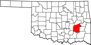 Pittsburg County map | |
| Towns | ||
| CDPs | ||
| Other unincorporated communities | ||
| Ghost town | ||
| Indian reservation | ||
| Footnotes | ‡This populated place also has portions in another county or counties | |
| ||
This article is issued from Wikipedia. The text is licensed under Creative Commons - Attribution - Sharealike. Additional terms may apply for the media files.
