Arrondissement of Ajaccio
The arrondissement of Ajaccio (French: arrondissement d'Ajaccio; Corsican: circundariu d'Aiacciu) is an arrondissement (district) in the department of Corse-du-Sud in the territorial collectivity of Corsica. It has 81 communes.[1] Its population is 113,473 (2016), and its area is 2,224.4 km2 (858.8 sq mi).[2]
Ajaccio | |
|---|---|
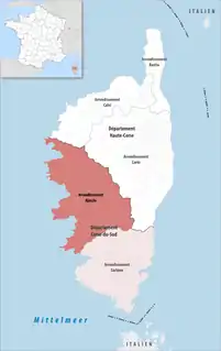 Location within the region Corsica | |
| Country | France |
| Region | Corsica |
| Department | Corse-du-Sud |
| No. of communes | 81 |
| Prefecture | Ajaccio |
| Area | |
| • Total | 2,224.4 km2 (858.8 sq mi) |
| Population (2016) | |
| • Total | 113,473 |
| • Density | 51/km2 (130/sq mi) |
| INSEE code | 2A1 |
Composition
The communes of the arrondissement of Ajaccio, and their INSEE codes, are:[1]
- Afa (2A001)
- Ajaccio (2A004)
- Alata (2A006)
- Albitreccia (2A008)
- Ambiegna (2A014)
- Appietto (2A017)
- Arbori (2A019)
- Arro (2A022)
- Azilone-Ampaza (2A026)
- Azzana (2A027)
- Balogna (2A028)
- Bastelica (2A031)
- Bastelicaccia (2A032)
- Bocognano (2A040)
- Calcatoggio (2A048)
- Campo (2A056)
- Cannelle (2A060)
- Carbuccia (2A062)
- Cardo-Torgia (2A064)
- Cargèse (2A065)
- Casaglione (2A070)
- Cauro (2A085)
- Ciamannacce (2A089)
- Coggia (2A090)
- Cognocoli-Monticchi (2A091)
- Corrano (2A094)
- Coti-Chiavari (2A098)
- Cozzano (2A099)
- Cristinacce (2A100)
- Cuttoli-Corticchiato (2A103)
- Eccica-Suarella (2A104)
- Évisa (2A108)
- Forciolo (2A117)
- Frasseto (2A119)
- Grosseto-Prugna (2A130)
- Guagno (2A131)
- Guargualé (2A132)
- Guitera-les-Bains (2A133)
- Letia (2A141)
- Lopigna (2A144)
- Marignana (2A154)
- Murzo (2A174)
- Ocana (2A181)
- Olivese (2A186)
- Orto (2A196)
- Osani (2A197)
- Ota (2A198)
- Palneca (2A200)
- Partinello (2A203)
- Pastricciola (2A204)
- Peri (2A209)
- Piana (2A212)
- Pietrosella (2A228)
- Pila-Canale (2A232)
- Poggiolo (2A240)
- Quasquara (2A253)
- Renno (2A258)
- Rezza (2A259)
- Rosazia (2A262)
- Salice (2A266)
- Sampolo (2A268)
- Santa-Maria-Siché (2A312)
- Sant'Andréa-d'Orcino (2A295)
- Sari-d'Orcino (2A270)
- Sarrola-Carcopino (2A271)
- Serra-di-Ferro (2A276)
- Serriera (2A279)
- Soccia (2A282)
- Tasso (2A322)
- Tavaco (2A323)
- Tavera (2A324)
- Tolla (2A326)
- Ucciani (2A330)
- Urbalacone (2A331)
- Valle-di-Mezzana (2A336)
- Vero (2A345)
- Vico (2A348)
- Villanova (2A351)
- Zévaco (2A358)
- Zicavo (2A359)
- Zigliara (2A360)
History
The arrondissement of Ajaccio was created as part of the department Liamone in 1800. Between 1811 and 1976 it was an arrondissement of the department Corse, since 1976 it has been an arrondissement of the department Corse-du-Sud.[3] In March 2017 it gained the commune Olivese from the arrondissement of Sartène.[4]
As a result of the reorganisation of the cantons of France which came into effect in 2015, the borders of the cantons are no longer related to the borders of the arrondissements. The cantons of the arrondissement of Ajaccio were, as of January 2015:[5]
References
- "Arrondissement d'Ajaccio (2A1)". INSEE. Retrieved 2019-09-28.
- "Comparateur de territoire, géographie au 01/01/2019". INSEE. Retrieved 2019-09-28.
- Historique de la Corse-du-Sud
- "Arrêté préfectoral, 7 March 2017" (PDF). pp. 84–85. Retrieved 2019-10-09.
- "Populations légales 2012" (PDF). INSEE. December 2014. Retrieved 2019-10-09.
| Authority control |
|
|---|