Arrondissement of Bobigny
The arrondissement of Bobigny is an arrondissement of France in the Seine-Saint-Denis department in the Île-de-France region. It has 9 communes.[1] Its population is 415,958 (2016), and its area is 39.2 km2 (15.1 sq mi).[2]
Bobigny | |
|---|---|
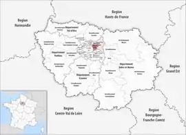 Location within the region Île-de-France | |
| Country | France |
| Region | Île-de-France |
| Department | Seine-Saint-Denis |
| No. of communes | 9 |
| Prefecture | Bobigny |
| Area | |
| • Total | 39.2 km2 (15.1 sq mi) |
| Population (2016) | |
| • Total | 415,958 |
| • Density | 10,611/km2 (27,480/sq mi) |
| INSEE code | 931 |
Composition
The communes of the arrondissement of Bobigny, and their INSEE codes, are:[1]
- Bagnolet (93006)
- Bobigny (93008)
- Bondy (93010)
- Les Lilas (93045)
- Montreuil (93048)
- Noisy-le-Sec (93053)
- Pantin (93055)
- Le Pré-Saint-Gervais (93061)
- Romainville (93063)
History
The arrondissement of Bobigny was created in 1964 as part of the department Seine. In 1968 it became part of the new department Seine-Saint-Denis.[3] The arrondissement of Saint-Denis was created in February 1993 from part of the arrondissement of Bobigny.[4] At the January 2017 reorganisation of the arrondissements of Seine-Saint-Denis, it lost six communes to the arrondissement of Le Raincy.[5]
As a result of the reorganisation of the cantons of France which came into effect in 2015, the borders of the cantons are no longer related to the borders of the arrondissements. The cantons of the arrondissement of Bobigny were, as of January 2015:[6]
- Bagnolet
- Bobigny
- Bondy-Nord-Ouest
- Bondy-Sud-Est
- Le Bourget
- Drancy
- Les Lilas
- Montreuil-Est
- Montreuil-Nord
- Montreuil-Ouest
- Noisy-le-Sec
- Pantin-Est
- Pantin-Ouest
- Les Pavillons-sous-Bois
- Romainville
- Rosny-sous-Bois
- Villemomble
References
- "Arrondissement de Bobigny (931)". INSEE. Retrieved 2019-10-05.
- "Comparateur de territoire, géographie au 01/01/2019". INSEE. Retrieved 2019-10-05.
- Historique de la Seine-Saint-Denis
- Décret n° 93-259 du 26 février 1993 portant création de l'arrondissement de Saint-Denis (Seine-Saint-Denis)
- "Arrêté préfectoral, 30 December 2016" (PDF). pp. 25–27. Retrieved 2019-10-28.
- "Populations légales 2012" (PDF). INSEE. December 2014. Retrieved 2019-10-28.