Arrondissement of Clermont-Ferrand
The arrondissement of Clermont-Ferrand is an arrondissement of France in the Puy-de-Dôme department in the Auvergne-Rhône-Alpes region. It has 74 communes.[1] Its population is 354,048 (2016), and its area is 912.6 km2 (352.4 sq mi).[2]
Clermont-Ferrand | |
|---|---|
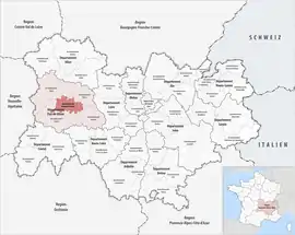 Location within the region Auvergne-Rhône-Alpes | |
| Country | France |
| Region | Auvergne-Rhône-Alpes |
| Department | Puy-de-Dôme |
| No. of communes | 74 |
| Prefecture | Clermont-Ferrand |
| Area | |
| • Total | 912.6 km2 (352.4 sq mi) |
| Population (2016) | |
| • Total | 354,048 |
| • Density | 388/km2 (1,000/sq mi) |
| INSEE code | 632 |
Composition
The communes of the arrondissement of Clermont-Ferrand, and their INSEE codes, are:[1]
- Aubière (63014)
- Aulnat (63019)
- Authezat (63021)
- Aydat (63026)
- Beaumont (63032)
- Beauregard-l'Évêque (63034)
- Billom (63040)
- Blanzat (63042)
- Bongheat (63044)
- Bouzel (63049)
- Busséol (63059)
- Cébazat (63063)
- Le Cendre (63069)
- Ceyrat (63070)
- Chamalières (63075)
- Chanonat (63084)
- Chas (63096)
- Châteaugay (63099)
- Chauriat (63106)
- Clermont-Ferrand (63113)
- Corent (63120)
- Cournols (63123)
- Cournon-d'Auvergne (63124)
- Le Crest (63126)
- Durtol (63141)
- Égliseneuve-près-Billom (63146)
- Espirat (63154)
- Estandeuil (63155)
- Fayet-le-Château (63157)
- Gerzat (63164)
- Glaine-Montaigut (63168)
- Isserteaux (63177)
- Laps (63188)
- Lempdes (63193)
- Manglieu (63205)
- Les Martres-de-Veyre (63214)
- Mauzun (63216)
- Mirefleurs (63227)
- Montmorin (63239)
- Mur-sur-Allier (63226)
- Neuville (63252)
- Nohanent (63254)
- Olloix (63259)
- Orcet (63262)
- Orcines (63263)
- Pérignat-lès-Sarliève (63272)
- Pérignat-sur-Allier (63273)
- Pignols (63280)
- Pont-du-Château (63284)
- Reignat (63297)
- La Roche-Blanche (63302)
- La Roche-Noire (63306)
- Romagnat (63307)
- Royat (63308)
- Saint-Amant-Tallende (63315)
- Saint-Bonnet-lès-Allier (63325)
- Saint-Dier-d'Auvergne (63334)
- Saint-Genès-Champanelle (63345)
- Saint-Georges-sur-Allier (63350)
- Saint-Jean-des-Ollières (63365)
- Saint-Julien-de-Coppel (63368)
- Saint-Maurice (63378)
- Saint-Sandoux (63395)
- Saint-Saturnin (63396)
- Sallèdes (63405)
- Saulzet-le-Froid (63407)
- La Sauvetat (63413)
- Tallende (63425)
- Trézioux (63438)
- Vassel (63445)
- Vertaizon (63453)
- Veyre-Monton (63455)
- Vic-le-Comte (63457)
- Yronde-et-Buron (63472)
History
The arrondissement of Clermont-Ferrand was created in 1800.[3] At the January 2017 reorganisation of the arrondissements of Puy-de-Dôme, it gained one commune from the arrondissement of Riom, and it lost three communes to the arrondissement of Ambert, 21 communes to the arrondissement of Issoire, 17 communes to the arrondissement of Riom and four communes to the arrondissement of Thiers.[4]
As a result of the reorganisation of the cantons of France which came into effect in 2015, the borders of the cantons are no longer related to the borders of the arrondissements. The cantons of the arrondissement of Clermont-Ferrand were, as of January 2015:[5]
- Aubière
- Beaumont
- Billom
- Bourg-Lastic
- Chamalières
- Clermont-Ferrand-Centre
- Clermont-Ferrand-Est
- Clermont-Ferrand-Nord
- Clermont-Ferrand-Nord-Ouest
- Clermont-Ferrand-Ouest
- Clermont-Ferrand-Sud
- Clermont-Ferrand-Sud-Est
- Clermont-Ferrand-Sud-Ouest
- Cournon-d'Auvergne
- Gerzat
- Herment
- Montferrand
- Pont-du-Château
- Rochefort-Montagne
- Royat
- Saint-Amant-Tallende
- Saint-Dier-d'Auvergne
- Vertaizon
- Veyre-Monton
- Vic-le-Comte
References
- "Arrondissement de Clermont-Ferrand (632)". INSEE. Retrieved 2019-10-03.
- "Comparateur de territoire, géographie au 01/01/2019". INSEE. Retrieved 2019-10-03.
- Historique du Puy-de-Dôme
- "Arrêté n° 16-536, 21 December 2016" (PDF). pp. 742–745. Retrieved 2019-10-22.
- "Populations légales 2012" (PDF). INSEE. December 2014. Retrieved 2019-10-22.