Artemisa Province
Artemisa Province is one of the two new provinces created from the former La Habana Province, whose creation was approved by the Cuban National Assembly on August 1, 2010, the other being Mayabeque Province.[2][3][4] The new provinces came into existence on January 1, 2011.
Artemisa Province | |
|---|---|
 Coat of arms | |
 | |
| Coordinates: 22°48′49″N 82°45′48″W | |
| Country | Cuba |
| Capital | Artemisa |
| Municipalities | Mariel, Guanajay, Caimito, Bauta, San Antonio de los Baños, Güira de Melena, Alquízar, Artemisa, Candelaria, San Cristóbal, Bahía Honda |
| Area | |
| • Total | 4,004.27 km2 (1,546.06 sq mi) |
| Highest elevation | 681 m (2,234 ft) |
| Population (2010-12-31)[1] | |
| • Total | 502,312 |
| • Density | 130/km2 (320/sq mi) |
| Time zone | UTC-5 (EST) |
| Area code(s) | +53-47 |
Overview
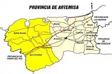
Artemisa was the largest city and municipality of the former La Habana Province. The newly formed province combined the eight western municipalities of La Habana Province and three eastern municipalities of neighbor province Pinar del Río (Bahía Honda, Candelaria and San Cristóbal). The capital and largest city is Artemisa (47,000 pop. in 2015).
The new province is only larger than Havana city and Mayabeque, but with more population than four other Cuban provinces. It is the most densely populated, after Havana city and Santiago de Cuba.
The economy of the Artemisa province is based mainly on agriculture (fruits, potatoes, rice, vegetables, sugar cane) and industry of building materials (two cement factories), food processing industry and power plants. It contains the important port of Mariel in the northern coast. The province is also important in the military sector with the main Cuban Air Force base (San Antonio de los Baños) the Western base of the Cuban Navy (Cabañas Bay) and the Military Academy (College) "Antonio Maceo" in Caimito.
Municipalities
| Municipality | km2 | Population |
|---|---|---|
| Mariel | 270.85 | 44,786 |
| Guanajay | 110.26 | 28,750 |
| Caimito | 239.4 | 39,304 |
| Bauta | 155.13 | 48,024 |
| San Antonio de los Baños | 126.37 | 49,942 |
| Güira de Melena | 199.22 | 39,821 |
| Alquízar | 194.36 | 32,501 |
| Artemisa | 688.7 | 82,917 |
| Bahía Honda | 784.14 | 45,124 |
| Candelaria | 301.42 | 20,283 |
| San Cristóbal | 934.4 | 70,940 |
| Total | 4,004.27 | 502,392 |
Source: Oficina Nacional de Estadísticas 2010[5]
Topography
The maximum elevation in the province is Guajaibon peak (700 meters), and is located near N 22 47' 19" W 83 21' 52" in Sierra del Rosario range.
See also
References
- "Lugar que ocupa el territorio según la superficie y la población" (PDF). Una MIRADA a Cuba (in Spanish). Oficina Nacional de Estadísticas. Cuba. 2010.
- La racionalidad como premisa Archived 2010-06-11 at the Wayback Machine - Periódico Granma
- Proponen en Pleno del Partido dos nuevas provincias cubanas: Artemisa y Mayabeque (+ Infografía) - Cubadebate
- ¿Por qué Artemisa y Mayabeque?
- Mejor atención al pueblo y más funcional Archived 2010-07-26 at the Wayback MachineDiario Granma
External links
 Media related to Artemisa Province at Wikimedia Commons
Places adjacent to Artemisa Province | |
|---|---|
| Current provinces | |||||||
|---|---|---|---|---|---|---|---|
| Current special municipality | |||||||
| Historical provinces | |||||||
| |||||||
| Authority control |
|---|