Artesia Municipal Airport
Artesia Municipal Airport (IATA: ATS[2], ICAO: KATS, FAA LID: ATS) is a city-owned, public-use airport located three nautical miles (6 km) west of the central business district of Artesia, a city in Eddy County, New Mexico, United States.[1] It is included in the National Plan of Integrated Airport Systems for 2011–2015, which categorized it as a general aviation facility.[3]
Artesia Municipal Airport | |||||||||||||||
|---|---|---|---|---|---|---|---|---|---|---|---|---|---|---|---|
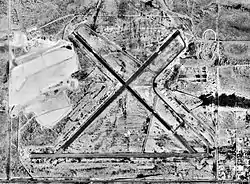 USGS 1997 orthophoto | |||||||||||||||
| Summary | |||||||||||||||
| Airport type | Public | ||||||||||||||
| Owner | City of Artesia | ||||||||||||||
| Serves | Artesia, New Mexico | ||||||||||||||
| Elevation AMSL | 3,541 ft / 1,079 m | ||||||||||||||
| Coordinates | 32°51′09″N 104°28′04″W | ||||||||||||||
| Map | |||||||||||||||
 ATS Location of airport in New Mexico | |||||||||||||||
| Runways | |||||||||||||||
| |||||||||||||||
| Statistics (2011) | |||||||||||||||
| |||||||||||||||
History
During 1943 and 1944 was used by the United States Army Air Forces as a contract glider training airfield. Big Spring Flying Service provided instruction. The mission of the school was to train glider pilot students in proficiency in operation of gliders in various types of towed and soaring flight, both day and night, and in servicing of gliders in the field. Used primarily C-47 Skytrains and Waco CG-4 unpowered Gliders.
The facility was deactivated on September 8, 1944, with the drawdown of AAFTC's pilot training program. Declared surplus and turned over to the Army Corps of Engineers on September 30, 1945. Eventually discharged to the War Assets Administration (WAA) and returned to being a civil airport. [4] [5] [6]
The airport saw scheduled airline service in 1963/1964 from Bison Airlines and again in 1975 through 1978 from Roswell Airlines which provided flights to Albuquerque and El Paso. Roswell Airlines changed to New Mexico Air before the company ceased operations.[7]
Facilities and aircraft
Artesia Municipal Airport covers an area of 1,440 acres (583 ha) at an elevation of 3,541 feet (1,079 m) above mean sea level. It has two runways with asphalt surfaces: 3/21 is 6,301 by 150 feet (1,921 x 46 m) and 12/30 is 5,390 by 150 feet (1,643 x 46 m).[1]
For the 12-month period ending April 6, 2011, the airport had 11,550 general aviation aircraft operations, an average of 31 per day. At that time there were 27 aircraft based at this airport: 74% single-engine, 19% multi-engine, and 7% jet.[1]
References
- FAA Airport Form 5010 for ATS PDF. Federal Aviation Administration. Effective May 31, 2012.
- "Airline and Airport Code Search". International Air Transport Association (IATA). Retrieved November 28, 2012.
- "2011–2015 NPIAS Report, Appendix A" (PDF). National Plan of Integrated Airport Systems. Federal Aviation Administration. October 4, 2010. Archived from the original (PDF, 2.03 MB) on 2012-09-27.
-
 This article incorporates public domain material from the Air Force Historical Research Agency website http://www.afhra.af.mil/.
 - Shaw, Frederick J. (2004), Locating Air Force Base Sites History’s Legacy, Air Force History and Museums Program, United States Air Force, Washington DC, 2004.
- Manning, Thomas A. (2005), History of Air Education and Training Command, 1942–2002. Office of History and Research, Headquarters, AETC, Randolph AFB, Texas ASIN: B000NYX3PC.
- Roswell Airlines timetables
External links
- The WW II Glider Pilots
- FAA Terminal Procedures for ATS, effective January 28, 2021
- Resources for this airport:
- FAA airport information for ATS
- AirNav airport information for KATS
- ASN accident history for ATS
- FlightAware airport information and live flight tracker
- NOAA/NWS weather observations: current, past three days
- SkyVector aeronautical chart, Terminal Procedures
| Flying Training |
|  | ||||
|---|---|---|---|---|---|---|
| Technical Training |
| |||||