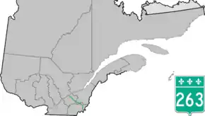
Quebec Route 263
Route 263 is a two-lane north/south highway on the south shore of the Saint Lawrence River in Quebec, Canada. Its northern terminus is in the community of Gentilly, part of Bécancour at the junction of Route 132, and the southern terminus is at the junction of Route 161 close to Saint-Augustin-de-Woburn.
| ||||
|---|---|---|---|---|
 | ||||
| Route information | ||||
| Length | 220.0 km[1] (136.7 mi) | |||
| Major junctions | ||||
| South end | ||||
| North end | ||||
| Location | ||||
| Major cities | Disraeli, Princeville | |||
| Highway system | ||||
| ||||

List of towns along Route 263
- Sainte-Marie-de-Blandford
- Lemieux
- Saint-Louis-de-Blandford
- Princeville
- Saint-Norbert-d'Arthabaska
- Sainte-Hélène-de-Chester
- Saint-Fortunat
- Saint-Jacques-le-Majeur-de-Wolfestown
- Disraeli
- Sainte-Praxède
- Saint-Romain
- Lambton
- Saint-Sébastien-de-Frontenac
- Sainte-Cécile-de-Whitton
- Marston
- Piopolis
- Saint-Augustin-de-Woburn
 View over Scotch Cap summit between Woburn and Piopolis.
 In Piopolis village.
 In Marsboro, Marston Township.
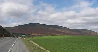 Mont Sainte-Cécile near Sainte-Cécile-Station.
 Morne de Saint-Sébastien near Saint-Sébastien.
 Entering Lemieux.
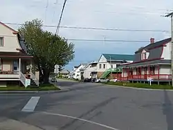 Junction with Quebec Route 226 in Sainte-Marie-de-Blandford.
See also
References
- Ministère des transports, "Distances routières", page (?), Les Publications du Québec, 2005
External links
- Route 263 on Google Maps
- Provincial Route Map (Courtesy of the Quebec Ministry of Transportation) (in French)
This article is issued from Wikipedia. The text is licensed under Creative Commons - Attribution - Sharealike. Additional terms may apply for the media files.