Aruba-Curaçao-Bonaire cactus scrub
The Aruba-Curaçao-Bonaire cactus scrub ecoregion (WWF ID:NT1302) covers the dry land on the semi-arid islands of Aruba, Curaçao, and Bonaire in the southern Caribbean Sea, about 80 km from the mainland of Venezuela. In low-lying coastal areas the islands also support mangrove wetlands. The landscape features a range of cactus species and acacia trees.[1][2] [3]
| Aruba-Curaçao-Bonaire cactus scrub | |
|---|---|
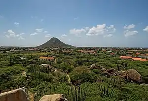 Hooiberg Mountain on Aruba | |
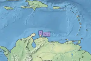 Ecoregion territory (islands in inset boxes) | |
| Ecology | |
| Realm | Neotropic |
| Biome | Deserts and xeric shrublands |
| Geography | |
| Area | 518 km2 (200 sq mi) |
| Country | Netherlands |
| Coordinates | 12.137°N 68.893°W |
Location and description
The three islands are on the coastal shelf of South America, with bedrock of limestone and quartz diorite. Aruba has an area of 179 km2, and is the most populated island with over 100,000 people. Curaçao, the middle island, has its highest point at Mt Christoffel of 372 metres (1,220 ft). Bonaire, the farthest island to the east, features a ringing coral reef and numerous inlets, lagoons, and mangrove forests. Some parts of the islands transition into the Guajira-Barranquilla xeric scrub ecoregion.[3]
Climate
The climate of the ecoregion is Semi-arid_climate#Hot_semi-arid_climates (Köppen climate classification (BSh)). This climate is characteristic of steppes, and in these islands supports a relatively even warm temperature of near 26.7 degrees C year-round. The trade winds from the Atlantic are a notable feature of the climate.[4][5] Precipitation averages 350-550 mm/year, with a wet season from October to December.[1]
Flora and fauna
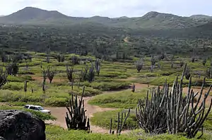
Most of the terrain is sparsely vegetated with cactus scrub. Common species of cactus are dagger cactus (Stenocereus griseus), Subpilocereus repandus (a Ceroid cactus), (Pilosocereus lanuginosus) (which is endemic to this ecoregion), melon cactus (Melocactus), and prickly pear (Opuntia). The columnar cactus can reach heights of 6 meters.[3] Aloe vera is an important commercial plant. The national tree of Curaçao is the distinctive divi divi tree (Libidibia coriaria), which is often contorted by the trade winds on the coast. Interspersed with the cactus are scrub or small trees such as twisted acacia (Vachellia tortuosa).
Protected areas
Officially protected areas on the islands include:
- Arikok National Park, on Aruba
- Christoffelpark, on Curaçao
- Washington Slagbaai National Park, on Bonaire
References
- "Aruba-Curacao-Bonaire cactus scrub". World Wildlife Federation.
- "Map of Ecoregions 2017". Resolve, using WWF data.
- "Aruba-Curacao-Bonaire cactus scrub". The Encyclopedia of Earth.
- Kottek, M., J. Grieser, C. Beck, B. Rudolf, and F. Rubel, 2006. "World Map of Koppen-Geiger Climate Classification Updated" (PDF). Gebrüder Borntraeger 2006. Retrieved September 14, 2019.CS1 maint: multiple names: authors list (link)
- "Dataset - Koppen climate classifications". World Bank. Retrieved September 14, 2019.
