Asientos
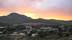
Asientos is a municipality and town in the Mexican state of Aguascalientes. It stands at 22°14′N 102°05′W. The town of Asientos serves as the municipal seat for the surrounding municipality of Asientos.
Asientos | |
|---|---|
 | |
 Coat of arms | |
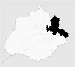 Municipality location in Aguascalientes | |
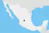
Asientos Location in Mexico | |
| Coordinates: 22°14′N 102°05′W | |
| Country | |
| State | Aguascalientes |
| Area | |
| • Total | 547.22 km2 (211.28 sq mi) |
| Population (2015) | |
| • Total | 46,464 |
| • Density | 85/km2 (220/sq mi) |
| Time zone | UTC-6 (CST) |
| • Summer (DST) | UTC-5 (CDT) |
As of 2010, the municipality had a total population of 45,492.[1]
Other than the town of Asientos, the municipality had 250 localities, the largest of which (with 2010 populations in parentheses) were: Villa Juárez (4,888), Ciénega Grande (3,348), classified as urban, and Guadalupe de Atlas (2,259), Lázaro Cárdenas (1,583), Pilotos (1,331), Bimbaletes Aguascalientes (El Álamo) (1,223), Molinos (1,219), El Tule (1,189), Noria del Borrego (Norias) (1,186), Licenciado Adolfo López Mateos (1,074), and Jarillas (1,041), classified as rural.[1]
Geography
| Year | Pop. | ±% |
|---|---|---|
| 2010 | 45,492 | — |
| 2015 | 46,464 | +2.1% |
| 2020 | 51,536 | +10.9% |
| [2][3][4][5] | ||
The municipality of Asientos is located in the north-east of the state and has a territorial area of 547.74 kilometres squared which is equivalent to 9.84% of the total area of the state and it has an altitude ranging from 1800 to 2700 metres above sea level.
It borders the municipality of Tepezalá to the north east, the municipality of Pabellón de Arteaga to the west, the municipalities of San Francisco de los Romo and Aguascalientes to the south east and the municipality of El Llano to the south. In the north and east, it borders the state of Zacatecas, specifically the municipalities of Loreto and Villa García; and in the south east, it borders the state of Jalisco, with the municipality of Ojuelos de Jalisco.
Government
The government of the municipality consists of the City Council, which is made up of a municipal president, a trustee and a council composed of nine members, five elected by relative majority and four by proportional representation. The city council is elected by universal, direct and secret vote in elections held on the first Sunday of July of the corresponding year.[6]
References
- "Asientos". Catálogo de Localidades. Secretaría de Desarrollo Social (SEDESOL). Retrieved 23 April 2014.
- "Localidades y su población por municipio según tamaño de localidad" (PDF) (in Spanish). INEGI. Archived from the original (PDF) on August 31, 2018. Retrieved July 15, 2017.
- "Número de habitantes". INEGI (National Institute of Statistics and Geography). Archived from the original on July 2, 2017. Retrieved July 15, 2017.
- "Tabulados de la Encuesta Intercensal 2015" (xls) (in Spanish). INEGI. Archived from the original on December 31, 2017. Retrieved July 15, 2017.
- "INEGI. Censo de Población y Vivienda 2020. Tabulados del Cuestionario Básico – Aguascalientes" [INEGI. 2020 Population and Housing Census. Basic Questionnaire Tabulations – Aguascalientes] (Excel) (in Spanish). INEGI. 2020. pp. 1–4. Archived from the original on 28 January 2021. Retrieved 27 January 2021.
- Instituto Nacional para el Federalismo y el Desarrollo Municipal. "Periodos de gobierno municipal". Archived from the original on June 16, 2011. Retrieved February 19, 2011.
External links
- https://web.archive.org/web/20040611143022/http://www.aguascalientes.gob.mx/estado/m_asie.html
- https://web.archive.org/web/20070315094440/http://www.e-local.gob.mx/work/templates/enciclo/aguascalientes/municipios/01002a.htm
- https://web.archive.org/web/20070830041302/http://www.aguascalientes.gob.mx/transparencia/otros/municipios/asientos.asp
- http://www.arellanomx.net/details.php?image_id=245%5B%5D