San Francisco de los Romo
San Francisco de los Romo is a municipality and city in the Mexican state of Aguascalientes. The city of San Francisco de los Romo serves as the municipal seat for the surrounding municipality of San Francisco de los Romo.
San Francisco de los Romo | |
|---|---|
 | |
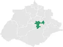 Municipality location in Aguascalientes | |
 San Francisco de los Romo Location in Mexico San Francisco de los Romo San Francisco de los Romo (Mexico) | |
| Coordinates: 22°05′N 102°16′W | |
| Country | |
| State | Aguascalientes |
| Area | |
| • Land | 139.452 km2 (53.843 sq mi) |
| Population (2015) | |
| • Total | 46,454 |
| • Density | 333.1/km2 (863/sq mi) |
It is located in the middle of the Aguascalientes Valley, at 20 km towards north from the state capital Aguascalientes; it adjoins with the municipalities of Pabellón de Arteaga and Asientos to the north, Jesús María to the west, and Aguascalientes to the south-east. The city, which is the state's sixth-largest community, is located at the northwest corner of the municipality.
Demographics
| Year | Pop. | ±% |
|---|---|---|
| 2010 | 35,769 | — |
| 2015 | 46,454 | +29.9% |
| 2020 | 61,997 | +33.5% |
| [1][2][3][4] | ||
As of 2010, the municipality had a total population of 35,769.[5]
As of 2010, the city of San Francisco de los Romo had a population of 16,124.[5] Other than the city of San Francisco de los Romo, the municipality had 117 localities, the largest of which (with 2010 populations in parentheses) were: Ex-viñedos Guadalupe (3,499), classified as urban, and Colonia Macario J. Gómez (2,122), Puertecito de la Virgen (1,976), Paseos de la Providencia (1,867), La Concepción (1,483), and La Escondida (El Salero) (1,318), classified as rural.[5]
San Francisco de los Romo is the sixth-largest community in the state, is located at the northwest corner of the municipality and serves as its municipal seat.
Climate
| Climate data for San Francisco de los Romo (1951–2010) | |||||||||||||
|---|---|---|---|---|---|---|---|---|---|---|---|---|---|
| Month | Jan | Feb | Mar | Apr | May | Jun | Jul | Aug | Sep | Oct | Nov | Dec | Year |
| Record high °C (°F) | 35.0 (95.0) |
37.0 (98.6) |
39.0 (102.2) |
43.0 (109.4) |
44.0 (111.2) |
42.0 (107.6) |
40.0 (104.0) |
39.0 (102.2) |
38.0 (100.4) |
39.0 (102.2) |
34.0 (93.2) |
38.0 (100.4) |
44.0 (111.2) |
| Average high °C (°F) | 22.9 (73.2) |
24.7 (76.5) |
28.2 (82.8) |
30.9 (87.6) |
32.6 (90.7) |
31.4 (88.5) |
28.9 (84.0) |
29.0 (84.2) |
27.7 (81.9) |
26.4 (79.5) |
24.7 (76.5) |
22.5 (72.5) |
27.5 (81.5) |
| Daily mean °C (°F) | 12.7 (54.9) |
13.9 (57.0) |
16.8 (62.2) |
19.6 (67.3) |
21.8 (71.2) |
22.5 (72.5) |
21.1 (70.0) |
20.9 (69.6) |
19.9 (67.8) |
17.5 (63.5) |
14.8 (58.6) |
13.1 (55.6) |
17.9 (64.2) |
| Average low °C (°F) | 2.5 (36.5) |
3.1 (37.6) |
5.3 (41.5) |
8.2 (46.8) |
11.1 (52.0) |
13.6 (56.5) |
13.2 (55.8) |
12.9 (55.2) |
12.1 (53.8) |
8.5 (47.3) |
4.8 (40.6) |
3.7 (38.7) |
8.3 (46.9) |
| Record low °C (°F) | −8.0 (17.6) |
−6.2 (20.8) |
−6.2 (20.8) |
−0.8 (30.6) |
0.0 (32.0) |
5.0 (41.0) |
5.0 (41.0) |
5.4 (41.7) |
2.0 (35.6) |
−4.1 (24.6) |
−4.2 (24.4) |
−6.0 (21.2) |
−8.0 (17.6) |
| Average precipitation mm (inches) | 15.5 (0.61) |
8.6 (0.34) |
7.3 (0.29) |
10.7 (0.42) |
19.5 (0.77) |
72.5 (2.85) |
94.5 (3.72) |
98.0 (3.86) |
87.1 (3.43) |
31.5 (1.24) |
12.6 (0.50) |
15.2 (0.60) |
473.0 (18.62) |
| Average precipitation days (≥ 0.1 mm) | 2.2 | 1.3 | 0.8 | 1.5 | 3.0 | 7.8 | 10.2 | 10.5 | 8.9 | 4.9 | 1.6 | 2.2 | 54.9 |
| Source: Servicio Meteorologico Nacional[6][7] | |||||||||||||
References
- Link to tables of population data from Census of 2005 Instituto Nacional de Estadística, Geografía e Informática (INEGI)
- Aguascalientes Enciclopedia de los Municipios de México
- "Localidades y su población por municipio según tamaño de localidad" (PDF) (in Spanish). INEGI. Archived from the original (PDF) on August 31, 2018. Retrieved July 15, 2017.
- "Número de habitantes". INEGI (National Institute of Statistics and Geography). Archived from the original on July 2, 2017. Retrieved July 15, 2017.
- "Tabulados de la Encuesta Intercensal 2015" (xls) (in Spanish). INEGI. Archived from the original on December 31, 2017. Retrieved July 15, 2017.
- "INEGI. Censo de Población y Vivienda 2020. Tabulados del Cuestionario Básico – Aguascalientes" [INEGI. 2020 Population and Housing Census. Basic Questionnaire Tabulations – Aguascalientes] (Excel) (in Spanish). INEGI. 2020. pp. 1–4. Archived from the original on 28 January 2021. Retrieved 27 January 2021.
- "San Francisco de los Romo". Catálogo de Localidades. Secretaría de Desarrollo Social (SEDESOL). Retrieved 23 April 2014.
- "Estado de Aguascalientes-Estacion: San Francisco de los Romo (SMN)". Normales Climatologicas 1951–2010 (in Spanish). Servicio Meteorologico Nacional. Archived from the original on 18 May 2015. Retrieved 8 May 2015.
- "Extreme Temperatures and Precipitation for San Francisco de los Romo (SMN) 1927–1983" (in Spanish). Servicio Meteorológico Nacional. Archived from the original on 18 May 2015. Retrieved 8 May 2015.
External links
- Ayuntamiento de San Francisco de los Romo Official website
- Gobierno del Estado de Aguascalientes Official website of State of Aguascalientes