Aspisheim
Aspisheim is an Ortsgemeinde – a municipality belonging to a Verbandsgemeinde, a kind of collective municipality – in the Mainz-Bingen district in Rhineland-Palatinate, Germany.
Aspisheim | |
|---|---|
 Coat of arms | |
Location of Aspisheim within Mainz-Bingen district  | |
 Aspisheim  Aspisheim | |
| Coordinates: 49°54′27″N 7°58′56″E | |
| Country | Germany |
| State | Rhineland-Palatinate |
| District | Mainz-Bingen |
| Municipal assoc. | Sprendlingen-Gensingen |
| Government | |
| • Mayor | Gunter Dautermann |
| Area | |
| • Total | 5.81 km2 (2.24 sq mi) |
| Elevation | 175 m (574 ft) |
| Population (2019-12-31)[1] | |
| • Total | 870 |
| • Density | 150/km2 (390/sq mi) |
| Time zone | UTC+01:00 (CET) |
| • Summer (DST) | UTC+02:00 (CEST) |
| Postal codes | 55459 |
| Dialling codes | 06727 |
| Vehicle registration | MZ |
| Website | www.aspisheim.de |
Geography
Location
Aspisheim lies in Rhenish Hesse between Mainz and Bad Kreuznach. The municipality is administered by the Verbandsgemeinde of Sprendlingen-Gensingen, whose seat is in Sprendlingen.
Politics
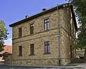
Aspisheim Town hall
Municipal council
The council is made up of 13 council members, counting the part-time mayor, with seats apportioned thus:
| Elections | FDP | Free voters FWG | Free voters WGG | Total |
|---|---|---|---|---|
| 2014 | 4 | 4 | 4 | 12 seats |
| 2009 | 7 | 5 | – | 12 seats |
| 2004 | 7 | 5 | – | 12 seats |
- FWG = Freie Wählergruppe Aspisheim e.V.
Coat of arms
The municipality's arms might be described thus: Per pale Or a yarn swift sable palewise and sable a lion rampant Or armed argent and langued gules.
Culture and sightseeing
Regular events
On the next-to-last weekend in August the municipality's residents stage the Rothesfest, a wine and street festival.
Economy and infrastructure
References
- "Bevölkerungsstand 2019, Kreise, Gemeinden, Verbandsgemeinden". Statistisches Landesamt Rheinland-Pfalz (in German). 2020.
External links
| Wikimedia Commons has media related to Aspisheim. |
- Municipality’s official webpage (in German)
| Authority control |
|---|
This article is issued from Wikipedia. The text is licensed under Creative Commons - Attribution - Sharealike. Additional terms may apply for the media files.
