Atawhai
Atawhai is one of the suburbs of Nelson, New Zealand. It lies north of Nelson and is the location of Wakapuaka Cemetery, a burial place since 1861. It also has a coastline on Nelson Haven and access to Boulder Bank from State Highway 6.[2][3]
Atawhai
Atawhai (Māori) | |
|---|---|
Township | |
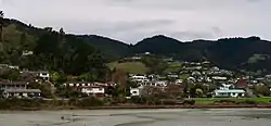 The suburb of Atawhai | |

| |
| Coordinates: 41°13′40″S 173°19′20″E | |
| Country | |
| Region | Nelson |
| Territorial authority | Nelson |
| Government | |
| • Nelson City Mayor | Rachel Reese |
| • Nelson MP | Rachel Boyack |
| • Te Tai Tonga MP | Rino Tirikatene |
| Area | |
| • Total | 1.01 km2 (0.39 sq mi) |
| • Land | 1.01 km2 (0.39 sq mi) |
| • Water | 0 km2 (0 sq mi) |
| Population (June 2020) | |
| • Total | 2,910[1] |
| Time zone | UTC+12 (NZST) |
| • Summer (DST) | UTC+13 (NZDT) |
| Postcode | 7010 |
| Area code(s) | 03 |
Geography
Atawhai covers an area of 4.53 km², including a land area of 4.53 km².[4]
Miyazu Japanese Garden, a Japanese public garden and public reserve, is located in Atawhai.[5]
Wakapuaka Cemetery is also located in the area.[5]
Atawhai also has several local parks: Bayview Reserve, Corder Park, Frenchay Reserve, Montrose Reserve, Ngapua Reserve, Queen Elizabeth II Reserve, Te-Ata Reserve, Titoki Reserve, Tresillian Reserve and Werneth Reserve.[5]
History and culture
The estimated population of Atawhai reached 2,000 in 1996.[6]
It reached 2,220 in 2001, 2,270 in 2006, 2,720 in 2013, and 2,830 in 2018.[6]
Whakatū Marae is located in Atawhai. It is the marae (meeting ground) of Ngāti Kōata, Ngāti Rārua, Ngāti Tama ki Te Tau Ihu, Ngāti Toa Rangatira and Te Atiawa o Te Waka-a-Māui. It includes the Kākāti wharenui (meeting house).[7][8]
Demography
Atawhai has an estimated population of . It has a population density of 642.06 people per km² as of 2019.[9]
As of the 2018 census, the median age was 43.9, the median income was $36,000, 8.3% of people earned over $100,00, 30.8% had a Bachelor's Degree or higher, and 2.7% of the workforce was unemployed.[6]
Ethnically, the population was 92.5% New Zealand European, 7.8% Māori, 1.4% Pacific peoples, 3.4% Asian, 0.6% Middle Eastern, Latin American, or African, and 1.6% identified with other ethnicities; 27.2% were born overseas.[6]
Religiously, the population is 60.4% non-religious and 29.6% Christian, and there are small Buddhist, Muslim and Hindu populations.[6]
Economy
In 2018, 6.9% worked in manufacturing, 8.5% worked in construction, 4.0% worked in hospitality, 4.6% worked in transport, 7.9% worked in education, and 13.5% worked in healthcare.[6]
Transport
As of 2018, among those who commute to work, 73.5% drove a car, 3.4% rode in a car, 7.1% use a bike, and 7.1% walk or run. No one used public transport.[6]
References
- "Population estimate tables - NZ.Stat". Statistics New Zealand. Retrieved 22 October 2019.
- "Wakapuaka Cemetery". Nelson.govt.nz. Retrieved 29 April 2014.
- "Boulder Bank". www.wonderwalkers.co.nz. Archived from the original on 29 April 2014. Retrieved 29 April 2014.
- "Statistical Area 2 2018 (generalised) GIS" (Data table). stats.govt.nz. Statistics New Zealand.
- "Nelson Parks and Reserves". gdc.govt.nz. Gisborne District Council.
- "Place Summary – Atawhai". Stats NZ. Statistics New Zealand.
- "Te Kāhui Māngai directory". tkm.govt.nz. Te Puni Kōkiri.
- "Māori Maps". maorimaps.com. Te Potiki National Trust.
- "Provisional Statistics". stats.govt.nz. Statistics New Zealand.
