Bílá Lhota
Bílá Lhota (German: Weissöhlhütten) is a municipality and village in Olomouc District in the Olomouc Region of the Czech Republic. It has about 1,200 inhabitants
Bílá Lhota | |
|---|---|
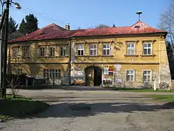 Bílá Lhota Chateau | |
 Flag  Coat of arms | |
 Bílá Lhota Location in the Czech Republic | |
| Coordinates: 49°42′34″N 16°58′30″E | |
| Country | |
| Region | Olomouc |
| District | Olomouc |
| First mentioned | 1350 |
| Area | |
| • Total | 18.22 km2 (7.03 sq mi) |
| Elevation | 395 m (1,296 ft) |
| Population (2020-01-01[1]) | |
| • Total | 1,153 |
| • Density | 63/km2 (160/sq mi) |
| Time zone | UTC+1 (CET) |
| • Summer (DST) | UTC+2 (CEST) |
| Postal code | 783 21, 783 24 |
| Website | www |
Administrative parts
Villages of Červená Lhota, Hrabí, Hradečná, Měník, Pateřín and Řimice are administrative parts of Slatinice.
References
- "Population of Municipalities – 1 January 2020". Czech Statistical Office. 2020-04-30.
| Wikimedia Commons has media related to Bílá Lhota. |
| Authority control |
|
|---|
This article is issued from Wikipedia. The text is licensed under Creative Commons - Attribution - Sharealike. Additional terms may apply for the media files.