Kožušany-Tážaly
Kožušany-Tážaly is a municipality in Olomouc District in the Olomouc Region of the Czech Republic. It has about 900 inhabitants.
Kožušany-Tážaly | |
|---|---|
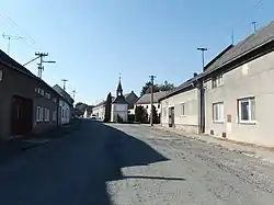 Centre of Tážaly | |
 Flag  Coat of arms | |
 Kožušany-Tážaly Location in the Czech Republic | |
| Coordinates: 49°32′23″N 17°15′14″E | |
| Country | |
| Region | Olomouc |
| District | Olomouc |
| First mentioned | 1078 |
| Area | |
| • Total | 6.27 km2 (2.42 sq mi) |
| Elevation | 227 m (745 ft) |
| Population (2020-01-01[1]) | |
| • Total | 872 |
| • Density | 140/km2 (360/sq mi) |
| Time zone | UTC+1 (CET) |
| • Summer (DST) | UTC+2 (CEST) |
| Postal code | 783 78 |
| Website | www |
Kožušany-Tážaly lies approximately 7 kilometres (4 mi) south of Olomouc and 213 km (132 mi) east of Prague.
Administrative parts
The municipality is made up of villages of Kožušany and Tážaly.
History
.JPG.webp)
Chapel of Saint Anne
The first written mention of Tážaly is from 1078, it is one of the oldest villages in the region. The first written mention of Kožušany is from 1297. Kožušany and Tážaly were two separate municipalities until 1960, when they were merged.[2]
The Chapel of Saint Anne in Kožušany was built in 1750. In 1880 the elementary school was built.[2]
References
- "Population of Municipalities – 1 January 2020". Czech Statistical Office. 2020-04-30.
- "Historie" (in Czech). Obec Kožušany-Tážaly. Retrieved 2020-11-19.
| Wikimedia Commons has media related to Kožušany-Tážaly. |
| Authority control |
|
|---|
This article is issued from Wikipedia. The text is licensed under Creative Commons - Attribution - Sharealike. Additional terms may apply for the media files.