Bagadó
Bagadó (Spanish pronunciation: [baɣaˈðo]) is a municipality and town in the Chocó Department, Colombia.
Bagadó | |
|---|---|
Municipality and town | |
.svg.png.webp) Flag  Seal | |
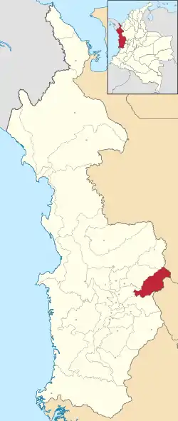 Location of the municipality and town of Bagadó in the Caquetá Department of Colombia. | |
| Country | |
| Department | Chocó Department |
| Founded | 1578 |
| Government | |
| • Mayor | Marinella Palomeque Serna |
| Area | |
| • Municipality and town | 777 km2 (300 sq mi) |
| Elevation | 200 m (656.2 ft) |
| Population (2015) | |
| • Municipality and town | 13,174 |
| • Density | 16.96/km2 (43.91/sq mi) |
| • Urban | 2,540 |
| Time zone | UTC-5 (Colombia Standard Time) |
Climate
Bagadó has an extremely wet tropical rainforest climate (Af).
| Climate data for Bagadó | |||||||||||||
|---|---|---|---|---|---|---|---|---|---|---|---|---|---|
| Month | Jan | Feb | Mar | Apr | May | Jun | Jul | Aug | Sep | Oct | Nov | Dec | Year |
| Average high °C (°F) | 30.1 (86.2) |
30.2 (86.4) |
30.6 (87.1) |
30.3 (86.5) |
30.2 (86.4) |
30.0 (86.0) |
30.3 (86.5) |
30.3 (86.5) |
30.2 (86.4) |
29.7 (85.5) |
29.5 (85.1) |
29.7 (85.5) |
30.1 (86.2) |
| Daily mean °C (°F) | 26.2 (79.2) |
26.3 (79.3) |
26.6 (79.9) |
26.5 (79.7) |
26.4 (79.5) |
26.2 (79.2) |
26.3 (79.3) |
26.3 (79.3) |
26.3 (79.3) |
25.9 (78.6) |
25.8 (78.4) |
26.0 (78.8) |
26.2 (79.2) |
| Average low °C (°F) | 22.4 (72.3) |
22.4 (72.3) |
22.7 (72.9) |
22.8 (73.0) |
22.7 (72.9) |
22.4 (72.3) |
22.4 (72.3) |
22.4 (72.3) |
22.5 (72.5) |
22.2 (72.0) |
22.2 (72.0) |
22.3 (72.1) |
22.5 (72.4) |
| Average rainfall mm (inches) | 553 (21.8) |
461 (18.1) |
507 (20.0) |
657 (25.9) |
721 (28.4) |
684 (26.9) |
636 (25.0) |
766 (30.2) |
732 (28.8) |
794 (31.3) |
714 (28.1) |
641 (25.2) |
7,866 (309.7) |
| Wikimedia Commons has media related to Bagadó. |
This article is issued from Wikipedia. The text is licensed under Creative Commons - Attribution - Sharealike. Additional terms may apply for the media files.
