Atrato
Atrato is a municipality and town in the Chocó Department near the Pacific Ocean, Colombia.
Atrato | |
|---|---|
Municipality and town | |
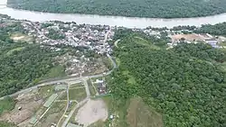 View of Atrato | |
.svg.png.webp) Flag | |
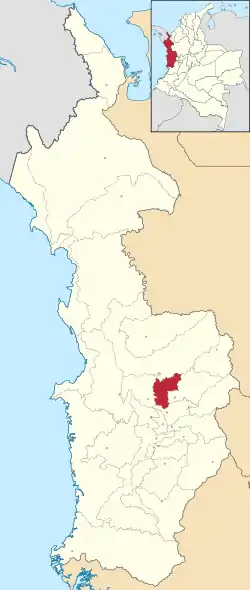 Location of the municipality and town of Atrato in the Chocó Department of Colombia. | |
| Country | |
| Department | Chocó Department |
| Area | |
| • Total | 725 km2 (280 sq mi) |
| Population (Census 2018[2]) | |
| • Total | 5,519 |
| • Density | 7.6/km2 (20/sq mi) |
| Time zone | UTC-5 (Colombia Standard Time) |
Climate
Atrato has an extremely wet tropical rainforest climate (Af). The following climate data is for Yutó, the capital of the municipality.
| Climate data for Atrato | |||||||||||||
|---|---|---|---|---|---|---|---|---|---|---|---|---|---|
| Month | Jan | Feb | Mar | Apr | May | Jun | Jul | Aug | Sep | Oct | Nov | Dec | Year |
| Average high °C (°F) | 29.9 (85.8) |
29.9 (85.8) |
30.3 (86.5) |
30.2 (86.4) |
30.1 (86.2) |
30.0 (86.0) |
30.1 (86.2) |
30.1 (86.2) |
30.0 (86.0) |
29.5 (85.1) |
29.4 (84.9) |
29.6 (85.3) |
29.9 (85.9) |
| Daily mean °C (°F) | 26.1 (79.0) |
26.1 (79.0) |
26.5 (79.7) |
26.5 (79.7) |
26.4 (79.5) |
26.2 (79.2) |
26.3 (79.3) |
26.3 (79.3) |
26.3 (79.3) |
25.9 (78.6) |
25.8 (78.4) |
26.0 (78.8) |
26.2 (79.1) |
| Average low °C (°F) | 22.4 (72.3) |
22.3 (72.1) |
22.7 (72.9) |
22.8 (73.0) |
22.7 (72.9) |
22.5 (72.5) |
22.5 (72.5) |
22.5 (72.5) |
22.6 (72.7) |
22.3 (72.1) |
22.3 (72.1) |
22.4 (72.3) |
22.5 (72.5) |
| Average rainfall mm (inches) | 607.2 (23.91) |
516.7 (20.34) |
526.1 (20.71) |
672.0 (26.46) |
795.9 (31.33) |
776.8 (30.58) |
768.5 (30.26) |
867.7 (34.16) |
742.9 (29.25) |
724.6 (28.53) |
722.2 (28.43) |
598.4 (23.56) |
8,319 (327.52) |
References
- (in Spanish) [ Colombian geografic Institute; Creation of the Atrato municipality]
- "Municipalities of Colombia". statoids. Retrieved 7 May 2020.
- "Censo Nacional de Población y Vivienda 2018" (in Spanish). DANE. Retrieved 7 May 2020.
| Gold |
|  |
|---|---|---|
| Silver | ||
| Platinum | ||
| Nickel |
| |
| Coltan | ||
| Emeralds | ||
| Coal | ||
| Salt | ||
| Sources | ||
This article is issued from Wikipedia. The text is licensed under Creative Commons - Attribution - Sharealike. Additional terms may apply for the media files.
