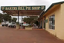
Bakers Hill, Western Australia
Bakers Hill is a town 73 kilometres (45 mi) east of Perth, Western Australia on the Great Eastern Highway. The town is located within the Shire of Northam, between Wundowie and Clackline. At the 2016 census, Bakers Hill had a population of 722.[1]
| Bakers Hill Western Australia | |||||||||
|---|---|---|---|---|---|---|---|---|---|
 Bakers Hill | |||||||||
 Bakers Hill | |||||||||
| Coordinates | 31.751°S 116.455°E | ||||||||
| Population | 722 (2016 census)[1] | ||||||||
| Established | 1897 | ||||||||
| Postcode(s) | 6562 | ||||||||
| Elevation | 330 m (1,083 ft) | ||||||||
| Location | |||||||||
| LGA(s) | Shire of Northam | ||||||||
| State electorate(s) | Central Wheatbelt | ||||||||
| Federal Division(s) | Pearce | ||||||||
| |||||||||
History
The town was originally known as Mount Baker in 1897. In 1902 the name was changed to Baker's Hill to avoid confusion with the town of Mount Barker in the Great Southern area. The apostrophe was removed from the name in 1944.[2]
Military history
During World War II, Bakers Hill was the location of the 62nd Field Park Company of the Royal Australian Engineers (RAE).
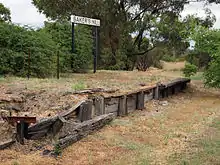
Railways
Bakers Hill was also a station and siding on the second route of the Eastern Railway between Midland Junction and Spencers Brook. This track was closed in 1966 when the route through the Avon Valley was opened.
Although the rail was removed in 1980, remnants of the old station platform are still visible.[3]
Climate
Bakers Hill has a Mediterranean climate with hot dry summers and cool, rather wet winters.
| Climate data for Bakers Hill | |||||||||||||
|---|---|---|---|---|---|---|---|---|---|---|---|---|---|
| Month | Jan | Feb | Mar | Apr | May | Jun | Jul | Aug | Sep | Oct | Nov | Dec | Year |
| Record high °C (°F) | 43.2 (109.8) |
44.6 (112.3) |
40.0 (104.0) |
37.8 (100.0) |
33.3 (91.9) |
24.2 (75.6) |
23.3 (73.9) |
27.0 (80.6) |
31.7 (89.1) |
36.6 (97.9) |
39.8 (103.6) |
42.0 (107.6) |
44.6 (112.3) |
| Average high °C (°F) | 31.8 (89.2) |
31.7 (89.1) |
28.5 (83.3) |
23.5 (74.3) |
19.2 (66.6) |
16.0 (60.8) |
15.1 (59.2) |
15.6 (60.1) |
17.5 (63.5) |
21.7 (71.1) |
25.6 (78.1) |
29.9 (85.8) |
23.0 (73.4) |
| Average low °C (°F) | 15.7 (60.3) |
16.1 (61.0) |
14.6 (58.3) |
12.3 (54.1) |
9.4 (48.9) |
7.6 (45.7) |
6.6 (43.9) |
6.4 (43.5) |
7.0 (44.6) |
8.9 (48.0) |
11.2 (52.2) |
14.0 (57.2) |
10.8 (51.4) |
| Record low °C (°F) | 7.8 (46.0) |
7.2 (45.0) |
6.2 (43.2) |
4.0 (39.2) |
2.4 (36.3) |
0.2 (32.4) |
0.6 (33.1) |
−2.9 (26.8) |
0.2 (32.4) |
0.5 (32.9) |
1.7 (35.1) |
5.5 (41.9) |
−2.9 (26.8) |
| Average precipitation mm (inches) | 16.0 (0.63) |
13.0 (0.51) |
17.4 (0.69) |
30.6 (1.20) |
71.1 (2.80) |
110.4 (4.35) |
113.7 (4.48) |
86.3 (3.40) |
64.0 (2.52) |
33.9 (1.33) |
20.8 (0.82) |
10.2 (0.40) |
581.3 (22.89) |
| Average precipitation days | 2.1 | 2.4 | 2.9 | 6.0 | 10.2 | 14.2 | 14.9 | 13.7 | 11.6 | 6.9 | 4.4 | 2.3 | 91.6 |
| Source: [4] | |||||||||||||
References
- Australian Bureau of Statistics (27 June 2017). "Bakers Hill (UCL)". 2016 Census QuickStats. Retrieved 22 April 2019.

- Western Australian Land Information Authority. "History of country town names – B". Retrieved 8 June 2007.
- Copley, Don (27 January 2005). "Stations, Sidings and Railway Locations Of Western Australia - Bakers Hill". Retrieved 8 June 2007.
- "Climate statistics for Bakers Hill". Bureau of Meteorology. Retrieved 12 July 2014.