Local government areas of Western Australia
The local government areas of Western Australia (LGAs) are those areas, towns and districts in Western Australia that manage their own affairs to the extent permitted by the Local Government Act 1995.[1] The Local Government Act 1995 also makes provision for regional local governments (referred to as "regional councils", established by two or more local governments for a particular purpose.[2]
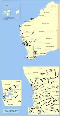
There are three classifications of local government in Western Australia:
- City – predominantly urban, some larger regional centres
- Town – predominantly inner urban, plus Port Hedland
- Shire – predominantly rural or outer suburban areas
The Shire of Christmas Island and the Shire of Cocos (Keeling) Islands are Federal external territories and covered by the Indian Ocean Territories Administration of Laws Act, which allows the Western Australian Local Government Act to apply "on-island" as though it were a Commonwealth act. Nonetheless, Christmas Island and the Cocos (Keeling) Islands are not part of Western Australia.
History
The first form of local government in Western Australia were town trusts established under the Towns Improvement Act of 1838.[3] Many of these town trusts, including the Perth town trust, experienced severe administrative and financial difficulties, and in some cases barely functioned at all.[4]
The District Roads Act and Municipal Institutions Act, both of 1871 improved matters by allowing for the establishment of Roads Boards and Municipal Corporations.[5] Municipal Corporations had the capacity to levy property taxes, pass municipal by-laws and undertake various local regulatory services previously carried out by colonial officials and other central bodies. Corporations could also establish civic institutions and facilities with the governors' consent, including libraries and botanical gardens.[4] Road Boards where strictly limited to the construction of roads, could not levy property taxes and depended on colonial government grants for any expenditures.
Women were permitted to be elected to Road Boards from 1911 and to Municipal Corporations from 1919.[6] The influence of town clerk WE Bold and the greater Perth movement around this time led to the amalgamation of inner city local governments to create a greatly expanded City of Perth until 1993, when the City was broken up once again.
The first local government department was established by the state in 1949 to guide local government authorities.[7] Following the war local governments increasingly expanded their services from property, health and local infrastructure (roads, drainage) to community and social services.
Only a few cities – Perth, Fremantle, Subiaco, South Perth and Nedlands – existed prior to 1961. On 1 July 1961, all road districts became shires, and all municipalities became towns or cities. This structure has continued till the present day.
In the 1970s, the scope of local government services expanded to encompass the provision of nursing homes and other forms of aged care.
During the late 1980s, and early 1990s a bi-partisan reform process led to the Local Government Act 1995, which amongst other changes, established for the first time a clear separation of responsibility between elected councillors and local government administration. Other key changes included a significant reduction in the number of decisions requiring ministerial approval which allowed for streamlined decision-making and greater local government autonomy.
In 2017 the McGowan government initiated a review process to reform the Local Government Act 1995.[8]
Although successive state governments have periodically promoted municipal amalgamation, only a small number of local governments have merged over the course of Western Australia's history. Historically most local governments have strongly resisted forced amalgamations[9] and the total number of authorities has declined only marginally over the last century. The most recent state government led effort to encourage the voluntary amalgamation of 30 metropolitan local governments into 16 was abandoned by the Barnett government in 2014.[10]
Metropolitan LGAs
| Local government area | Council seat[11] | Year est. | Land area[12] | Population density (2018)[12] | Population | Notes | ||
|---|---|---|---|---|---|---|---|---|
| km² | sq mi | 2013[13] | 2018[13][12] | |||||
| Armadale, City of | Armadale | 1894 | 560 | 216 | 157 | 72,662 | 87,634 | Armadale-Kelmscott until 1979 |
| Bassendean, Town of | Bassendean | 1901 | 10 | 4 | 1,521 | 15,828 | 15,739 | West Guildford until 1922 |
| Bayswater, City of | Morley | 1897 | 35 | 14 | 1,971 | 69,083 | 68,232 | |
| Belmont, City of | Cloverdale | 1898 | 40 | 15 | 1,042 | 39,919 | 41,510 | |
| Cambridge, Town of | Floreat | 1994 | 22 | 8 | 1,297 | 27,856 | 28,481 | Split from Perth |
| Canning, City of | Cannington | 1907 | 65 | 25 | 1,433 | 93,491 | 92,965 | Placed under control of a Commissioner in 2012 |
| Claremont, Town of | Claremont | 1898 | 5 | 2 | 2,160 | 10,220 | 10,704 | |
| Cockburn, City of | Spearwood | 1871 | 168 | 65 | 668 | 102,787 | 112,165 | Fremantle RD until 1959 |
| Cottesloe, Town of | Cottesloe | 1895 | 3.9 | 2 | 2,151 | 8,409 | 8,188 | |
| East Fremantle, Town of | East Fremantle | 1897 | 3.1 | 1 | 2,489 | 7,740 | 8,711 | |
| Fremantle, City of | Fremantle | 1871 | 19 | 7 | 1,624 | 30,156 | 30,868 | |
| Gosnells, City of | Gosnells | 1907 | 127 | 49 | 969 | 119,381 | 123,325 | |
| Joondalup, City of | Joondalup | 1998 | 99 | 38 | 1,618 | 164,414 | 160,031 | Split from Wanneroo |
| Kalamunda, City of | Kalamunda | 1897 | 324 | 125 | 182 | 58,622 | 58,946 | Governed by a Commissioner until 1961 |
| Kwinana, City of | Kwinana Town Centre | 1954 | 120 | 46 | 363 | 34,707 | 43,511 | |
| Melville, City of | Booragoon[14] | 1900 | 53 | 20 | 1,929 | 104,319 | 101,940 | |
| Mosman Park, Town of | Mosman Park | 1899 | 4.3 | 2 | 2,086 | 9,217 | 9,067 | Split from Peppermint Grove RD. Buckland Hill RD 1899–1908, 1930–1937; Cottesloe Beach RD 1908–1930 |
| Mundaring, Shire of | Mundaring | 1903 | 643 | 248 | 61 | 39,644 | 39,139 | Greenmount until 1932 |
| Nedlands, City of | Nedlands | 1893 | 20 | 8 | 1,148 | 22,665 | 22,554 | Claremont RD until 1932 |
| Peppermint Grove, Shire of | Peppermint Grove | 1895 | 1.1 | 0 | 1,612 | 1,694 | 1,721 | |
| Perth, City of | Perth | 1856 | 14 | 5 | 2,024 | 24,317 | 27,762 | |
| Rockingham, City of | Rockingham | 1897 | 258 | 100 | 518 | 119,300 | 133,389 | |
| Serpentine–Jarrahdale, Shire of | Mundijong | 1894 | 901 | 348 | 34 | 22,011 | 30,933 | |
| South Perth, City of | South Perth | 1892 | 19.8 | 8 | 2,198 | 44,348 | 43,554 | |
| Stirling, City of | Stirling | 1871 | 105 | 41 | 2,103 | 218,043 | 220,249 | Shire of Perth until 1971 |
| Subiaco, City of | Subiaco | 1896 | 5.6 | 2 | 3,045 | 16,466 | 17,106 | |
| Swan, City of | Midland | 1871 | 1,043 | 403 | 138 | 123,643 | 143,374 | |
| Victoria Park, Town of | Victoria Park | 1994 | 18 | 7 | 2,040 | 36,260 | 36,601 | Split from Perth |
| Vincent, City of | Leederville | 1994 | 11 | 4 | 3,172 | 35,442 | 36,088 | Split from Perth |
| Wanneroo, City of | Wanneroo | 1902 | 683 | 264 | 298 | 176,627 | 203,679 | |
Non-metropolitan LGAs
Regional local government organisations
- Bunbury Harvey Regional Council, comprising the LGAs of City of Bunbury and Shire of Harvey[16]
- Eastern Metropolitan Regional Council, comprising the LGAs of Town of Bassendean, City of Bayswater, City of Belmont, City of Kalamunda, Shire of Mundaring and City of Swan[17]
- Mindarie Regional Council, comprising the LGAs of Town of Cambridge, City of Joondalup, City of Perth, City of Stirling, Town of Victoria Park, City of Vincent and City of Wanneroo[18]
- Murchison Regional Vermin Council, comprising the LGAs of Shire of Cue, Shire of Meekatharra, Shire of Mount Magnet, Shire of Sandstone and Shire of Yalgoo[19]
- Pilbara Regional Council, comprising the LGAs of Shire of Ashburton, Shire of East Pilbara, City of Karratha and Town of Port Hedland[20]
- Rivers Regional Council, comprising the LGAs of City of Armadale, City of Gosnells, City of Mandurah, Shire of Murray, Shire of Serpentine–Jarrahdale and City of South Perth[21]
- Southern Metropolitan Regional Council, comprising the LGAs of City of Cockburn, Town of East Fremantle, City of Fremantle, City of Kwinana and City of Melville[22]
- Tamala Park Regional Council, comprising the LGAs of Town of Cambridge, City of Joondalup, City of Perth, City of Stirling, Town of Victoria Park, City of Vincent and City of Wanneroo[23]
- Warren Blackwood Alliance of Councils, comprising the LGAs of Shire of Bridgetown–Greenbushes, Shire of Donnybrook–Balingup, Shire of Manjimup and Shire of Nannup.
- Western Metropolitan Regional Council, comprising the LGAs of Town of Claremont, Town of Cottesloe, Town of Mosman Park, Shire of Peppermint Grove and City of Subiaco[24]
References
- "Local Government Act 1995". Retrieved 26 July 2011.
- Refer Part 3 Division 4 of the "Local Government Act 1995". Retrieved 26 July 2011.
- Gregory, Jenny; Gothard, Janice; Gregory, Jenny; Gothard, Jan (2009), Historical encyclopedia of Western Australia, University of Western Australia Press, ISBN 978-1-921401-15-2 - Berry, Christopher Local Government pp.540-542. the act enabled the establishment of Town Trusts.
- Johns, J. R. H. (1949). "The Development of Local Government in Western Australia". The Australian Journal of Public Administration: 172–179.
- District Roads Act 1871.
- "History". Western Australia Local Government Association. Retrieved 7 October 2020.
- Committee for Perth (September 2009) ‘Successful’ Metropolitan Local Government Models: Potential Lessons for Perth
- "Local Government Act Review". Department of Local Government, Sport and Cultural Industries. 25 June 2019.
- Consolidation in Local Government: A Fresh Look (May 2011), p16
- Foster, Brendan; Riddell, Alex (8 February 2015). "Council mergers scrapped after ratepayer polls". WA Today.
- Department of Health. "Local Government contacts". Retrieved 26 July 2009.
- "3218.0 – Regional Population Growth, Australia, 2017-18: Population Estimates by Local Government Area (ASGS 2018), 2017 to 2018". Australian Bureau of Statistics. Australian Bureau of Statistics. 27 March 2019. Retrieved 25 October 2019. Estimated resident population, 30 June 2018.
- "People: Population: ERP by LGA (ASGS 2018), 2001 to 2018". ABS.Stat. Australian Bureau of Statistics. 27 March 2019. Retrieved 29 November 2019.
- Contact Us – City of Melville
- "ERP by SA2 and above (ASGS 2016), 2001 onwards". ABS.Stat. Australian Bureau of Statistics. 27 March 2019. Retrieved 7 December 2019.
- "Bunbury Harvey Regional Council". Retrieved 19 April 2016.
- "Eastern Metropolitan Regional Council". Retrieved 19 April 2016.
- "Mindarie Regional Council". Retrieved 19 April 2016.
- "Murchison Regional Vermin Council". Retrieved 3 August 2017.
- "Pilbara Regional Council". Retrieved 19 April 2016.
- "Rivers Regional Council". Retrieved 19 April 2016.
- "Southern Metropolitan Regional Council". Retrieved 19 April 2016.
- "Tamala Park Regional Council". Retrieved 19 April 2016.
- "Western Metropolitan Regional Council". Retrieved 19 April 2016.
External links
- "Shires of Australia". Statoids.