Baleshare
Baleshare (Scottish Gaelic: Baile Sear) is a flat tidal island in the Outer Hebrides of Scotland.
| Scottish Gaelic name | Am Baile Sear |
|---|---|
| Meaning of name | Gaelic for 'east town'. |
| Location | |
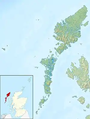 Baleshare Baleshare shown within the Outer Hebrides | |
| OS grid reference | NF788619 |
| Coordinates | 57.53°N 7.37°W |
| Physical geography | |
| Island group | Uists and Barra |
| Area | 910 hectares (3.5 sq mi) |
| Area rank | 54 [1] |
| Highest elevation | 12 metres (39 ft) |
| Administration | |
| Sovereign state | United Kingdom |
| Country | Scotland |
| Council area | Na h-Eileanan Siar |
| Demographics | |
| Population | 58[2] |
| Population rank | 56 [1] |
| Population density | 6.4 people/km2[2][3] |
| Largest settlement | Samhla |
| References | [3][4][5] |

Baleshare lies to the south-west of North Uist. Its economics and community were boosted by the building of a causeway in 1962. The 350 m (380 yd) causeway was built by William Tawse Ltd.[6] The island is extremely flat by Hebridean standards, rising to only 12 metres (39 feet) above sea level and known for its long sandy beach. It has a population of 49 living in two settlements: Samhla and Teananachar.
The name means 'east farm' or 'east town'. The 'west town' may have been on land that was said to exist to the west of Baleshare, washed away in the sixteenth century, over which it was possible to walk to the Monach Islands at low tide.[3] The Monachs are some 15 kilometres (9.3 miles) to the west. Another story suggests there was once a land bridge to Kirkibost, 100 metres (330 feet) to the north.[7] The basis for this seems to be a reference in the Exchequer Rolls for 1542 that the valued rental had been decreased due to encroachment by the sea at some unspecified (presumably recent) date.
Two prehistoric settlements have been uncovered, which contain the remains of a circular stone house and pieces of pottery, bone and metal. In common with other sites in the area, they are threatened by coastal erosion.[8][9]
Notable people from Baleshare
- John Fergusson, Nova Scotia politician.[10]
References
- Area and population ranks: there are c. 300 islands over 20 ha in extent and 93 permanently inhabited islands were listed in the 2011 census.
- National Records of Scotland (15 August 2013). "Appendix 2: Population and households on Scotland's Inhabited Islands" (PDF). Statistical Bulletin: 2011 Census: First Results on Population and Household Estimates for Scotland Release 1C (Part Two) (PDF) (Report). SG/2013/126. Retrieved 14 August 2020.
- Haswell-Smith, Hamish (2004). The Scottish Islands. Edinburgh: Canongate. ISBN 978-1-84195-454-7.
- Ordnance Survey. "View: Sheet 17 - North Uist - Ordnance Survey One-inch to the mile maps of Great Britain, Seventh Series, 1952-1961". National Library of Scotland. National Library of Scotland. Retrieved 23 January 2016.
- Mac an Tàilleir, Iain (2003) Ainmean-àite/Placenames. (pdf) Pàrlamaid na h-Alba. Retrieved 26 August 2012.
- "Baleshare Causeway". Gazetteer for Scotland. Retrieved 18 August 2007.
- "Western Isles: Baleshire". BBC Scotland. Retrieved 18 August 2007.
- Jamie Beatson (30 May 2007). "History at risk from erosion by the sea". The Scotsman. Archived from the original on 16 July 2012. Retrieved 18 August 2007.
- Barber, John (2003) Bronze Age Farms and Iron Age Farm Mounds of the Outer Hebrides. Scottish Archaeological Report 3. Archived 2007-08-10 at the Wayback Machine Retrieved 18 August 2007.
- The Canadian parliamentary companion, HJ Morgan (1874)
External links
|  | ||||||||||||||||
|
| |||||||||||||||||
| |||||||||||||||||
| |||||||||||||||||
| |||||||||||||||||
| |||||||||||||||||
| |||||||||||||||||
| |||||||||||||||||
