Bang Krathum District
Bang Krathum (Thai: บางกระทุ่ม, pronounced [bāːŋ krā.tʰûm]) is a district (amphoe) in the Phitsanulok Province, Thailand.
Bang Krathum
บางกระทุ่ม | |
|---|---|
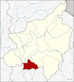 District location in Phitsanulok Province | |
| Coordinates: 16°35′7″N 100°18′22″E | |
| Country | Thailand |
| Province | Phitsanulok |
| Seat | Bang Krathum |
| District established | 1927 |
| Area | |
| • Total | 447.03 km2 (172.60 sq mi) |
| Population (2009) | |
| • Total | 48,667 |
| • Density | 111.0/km2 (287/sq mi) |
| Time zone | UTC+7 (ICT) |
| Postal code | 65110 |
| Geocode | 6505 |
Etymology
Bang (Thai: บาง) means 'village' or 'settlement'. The second element krathum (Thai: กระทุ่ม) means 'bur-flower tree' (Neolamarckia cadamba).
Geography
Neighboring districts are (from the north clockwise), Mueang Phitsanulok and Wang Thong of Phitsanulok Province; Sak Lek, Mueang Phichit, and Sam Ngam of Phichit Province. Most of Bang Krathum lies within the Nan Basin, although a narrow strip of land on the west side of the district lies within the Yom Basin. Both basins are part of the Chao Phraya Watershed. The Nan, Wang Thong and Wat Ta Yom Rivers flow through Bang Krathum, and the Yom River forms part of the border between Bang Krathum and Phichit.
History
The minor district (king amphoe) Bang Krathum was created in 1927 by combining three sub-districts from Mueang Phitsanulok District and three sub-districts from Pa Mak District, the present-day Wang Thong District.[1] Originally a subordinate of Mueang Phitsanulok District, it was upgraded to a full district in 1946.[2]
Administration
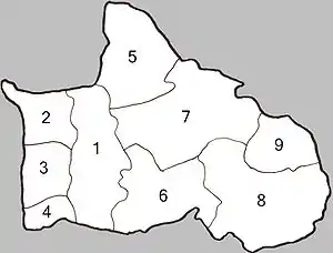
The district is divided into nine sub-districts (tambons), which are further subdivided into 87 mubans, which are divisions at the village level. Many villages occupy more than one muban. There are two sub-district municipalities (thesaban tambon). Bang Krathum covers parts of tambon Bang Krathum, and Noen Kum covers the tambon Noen Kum and Wat Ta Yom. There are a further seven tambon administrative organizations (TAO).[3]
| No. | Name | Thai | Villages | Pop.[4] |
|---|---|---|---|---|
| 1. | Bang Krathum | บางกระทุ่ม | 9 | 6,823 |
| 2. | Ban Rai | บ้านไร่ | 10 | 4,558 |
| 3. | Khok Salut | โคกสลุด | 10 | 3,265 |
| 4. | Sanam Khli | สนามคลี | 6 | 2,519 |
| 5. | Tha Tan | ท่าตาล | 9 | 6,868 |
| 6. | Phai Lom | ไผ่ล้อม | 11 | 4,681 |
| 7. | Nakhon Pa Mak | นครป่าหมาก | 13 | 6,472 |
| 8. | Noen Kum | เนินกุ่ม | 11 | 8,968 |
| 9. | Wat Ta Yom | วัดตายม | 8 | 4,513 |
Economy
Bang Krathum's chief crops are rice, sugar cane, fruits, oranges, tamarinds, cassavas, soy beans and mung beans.[3]
In Bang Krathum, there are a number of "banana factories" that package an assortment of dried fruits including dried bananas and tamarinds that are sold in Thailand and exported worldwide. There is also a large sugar cane production plant in the district owned by Phitsanulok Sugar Co., Ltd.[5]
Settlements
Of the 51 villages in Bang Krathum District, those that occupy multiple mubans are as follows:[6]
- Ban Bang Krathum
- Ban Dong Mee
- Ban Grong Greng
- Ban Kok Salud
- Ban Khok Sanam
- Ban Noen Kum
- Ban Sam Ruen
- Ban Sanam Khli
- Ban Tha Makam
- Ban Tha Na
- Ban Tha Tan
- Ban Wat Kwang
- Ban Wat Ta Yom
- Ban Yan Yao
Temples
There are 44 Theravada Buddhist temples in the district. At least one, Wat Grung See Jayrin, has a historic chedi.
Attractions
Flooding
In 2006, there were reported cases of leptospirosis among residents of Bang Krathum, contracted due to standing water.[8]
References
- แจ้งความกระทรวงมหาดไทย เรื่อง ตั้งกิ่งอำเภอบางกระทุ่ม จังหวัดพิษณุโลก (PDF). Royal Gazette (in Thai). 44 (0 ง): 1231. 1927-07-17.
- ประกาศสำนักนายกรัฐมนตรี เรื่อง ตั้งกิ่งอำเภอบางกระทุ่ม อำเภอเมืองพิษณุโลก ขึ้นเป็นอำเภอ (PDF). Royal Gazette (in Thai). 63 (58 ง): 1235–1236. September 3, 1946.
- Amphoe.com(Thai) Archived 2007-09-27 at the Wayback Machine
- "Population statistics 2009". Department of Provincial Administration. Archived from the original on 2016-03-04.
- IPP Awards (Status as of September 2006)
- Amphoe Bang Krathum at Pitlocal.org (Thai)
- Ban Dongphayom Boat Race at Department of Agriculture Extension Archived 2007-09-19 at the Wayback Machine (Thai)
- "Leptospirosis Kills 31 In Past Eight Months". The Nation. 2006-09-12. Archived from the original on 30 September 2017. Retrieved 30 September 2017 – via Food and Drug Administration (FDA) Resource Center.
