Baptism River
The Baptism River is an 8.8-mile-long (14.2 km)[4] river of the U.S. state of Minnesota. The river source is the confluence of the East Branch Baptism River and the West Branch Baptism River just south of the community of Finland.[2]
| Baptism River | |
|---|---|
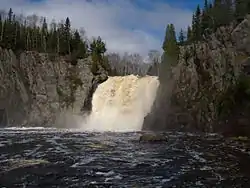 High Falls on the Baptism River, Tettegouche State Park | |
| Location | |
| Country | United States |
| Physical characteristics | |
| Source | |
| • location | Minnesota |
| • coordinates | 47°24′48″N 91°14′38″W[1] |
| • elevation | 1,290 feet (390 m)[2] |
| Mouth | |
• location | Lake Superior |
• coordinates | 47°20′10″N 91°11′52″W[1] |
• elevation | 600 feet (180 m) |
| Length | 8.8 miles (14.2 km) |
| Basin size | 53,900 acres (218 km2)[3] |
The High Falls of the Baptism River, in Tettegouche State Park, is the highest waterfall entirely within the state of Minnesota at 60 feet (18 m). The High Falls on the Pigeon River is higher, but is on the border with Ontario.
See also
References
- U.S. Geological Survey Geographic Names Information System: Baptism River
- Finland, MN, 7.25 Minute Topographic Quadrangle, USGS, 1956 (1978 rev.)
- "Lake Superior Streams - Baptism River". LakeSuperiorStreams.org. Archived from the original on 2011-02-19. Retrieved 2011-02-18.
- U.S. Geological Survey. National Hydrography Dataset high-resolution flowline data. The National Map Archived 2012-04-05 at WebCite, accessed May 7, 2012
- Minnesota Watersheds
- USGS Hydrologic Unit Map - State of Minnesota (1974)
This article is issued from Wikipedia. The text is licensed under Creative Commons - Attribution - Sharealike. Additional terms may apply for the media files.
