Brule River (Minnesota)
The Brule River is a river of the U.S. state of Minnesota. The Brule River originates at Vista Lake in the Boundary Waters Canoe Area Wilderness and flows 40.4 miles (65.0 km)[1] east and southeast, terminating at Lake Superior approximately 14 mi (23 km) northeast of Grand Marais, Minnesota, within the boundaries of Judge C. R. Magney State Park.[2][3] A major tributary is the South Brule River, which rises at the east end of Brule Lake in the Boundary Waters Canoe Area Wilderness.
| Brule River (Minnesota) | |
|---|---|
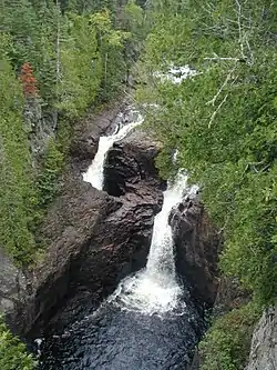 The Devil's Kettle | |
| Location | |
| Country | United States |
| Physical characteristics | |
| Source | |
| • location | Minnesota |
| Mouth | |
• location | Lake Superior |
Brule River is a name derived from the French meaning "burnt".[4]
Half of the river disappears into a pothole known as "the Devil's Kettle" in Judge C. R. Magney State Park.
See also
References
- U.S. Geological Survey. National Hydrography Dataset high-resolution flowline data. The National Map Archived 2012-04-05 at WebCite, accessed May 2, 2012
- "JUDGE C.R. MAGNEY STATE PARK" (PDF). Retrieved 30 May 2016.
- "North Shore Minnesota Waterfalls - Highest in the State". Retrieved 30 May 2016.
- Warren Upham (1920). Minnesota Geographic Names: Their Origin and Historic Significance. Minnesota Historical Society. p. 144.
- U.S. Geological Survey Geographic Names Information System: Brule River
Further reading
- Minnesota Watersheds
- USGS Hydrologic Unit Map - State of Minnesota (1974)
This article is issued from Wikipedia. The text is licensed under Creative Commons - Attribution - Sharealike. Additional terms may apply for the media files.