Baratang Island
Baratang Island is an island of the Andaman Islands. It belongs to the North and Middle Andaman administrative district, part of the Indian union territory of Andaman and Nicobar Islands.[5] The island lies 150 km (93 mi) north of Port Blair.
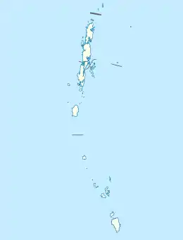 Baratang Island Location of Baratang Island | |
| Geography | |
|---|---|
| Location | Bay of Bengal |
| Coordinates | 12.18°N 92.80°E |
| Archipelago | Andaman Islands |
| Adjacent bodies of water | Indian Ocean |
| Area | 242.6 km2 (93.7 sq mi)[1] |
| Length | 27.8 km (17.27 mi) |
| Width | 14 km (8.7 mi) |
| Coastline | 117 km (72.7 mi) |
| Administration | |
| District | North and Middle Andaman |
| Island group | Andaman Islands |
| Great Andaman | |
| Taluk | Rangat |
| Largest settlement | Nilambur (pop. 1600) |
| Divisional Forest Officer | Vipul Pandey |
| Demographics | |
| Population | 5691 (2011)census 2011, only villages on Baratang |
| Pop. density | 23.45/km2 (60.74/sq mi) |
| Ethnic groups | Hindu, Munda, Khadiya, Chotanagpuri |
| Additional information | |
| Time zone |
|
| PIN | 744202[2] |
| Telephone code | 031927[3] |
| ISO code | IN-AN-00[4] |
| Official website | www |
| Literacy | 75.4% |
| Avg. summer temperature | 30.2 °C (86.4 °F) |
| Avg. winter temperature | 23.0 °C (73.4 °F) |
| Sex ratio | 1.05♂/♀ |
| Census Code | 35.639.0002 |
| Official Languages | Hindi, English |
History
Ranchiwalas Island is another name for Baratang Island. Towards the close of the nineteenth century, the city of Ranchi experienced political upheaval. Many locals sought refuge by converting to Christianity with the help of the missionaries there. The British, realizing the future prospects of the forests of Andaman and Nicobar islands, sent the converts to Baratang Island to cultivate crops. The laborers from Ranchi settled there and made new lives for themselves.[6] A lighthouse was commissioned in 1985 at the eastern entrance to the Andaman strait.[7]
Geography
The island belongs to the Great Andaman Chain, and with an area of 242.6 square kilometres (93.7 sq mi) it is one of the main islands of the group, a closely set archipelago in the Bay of Bengal, adjoining the Andaman Sea. Middle Andaman is to its north, and South Andaman to the south. Beaches, mangrove creeks, limestone caves, and mud volcanoes are some of the physical features.[8] The islands of Ritchie's Archipelago lie 14 kilometres (8.7 mi) to the east. Port Blair, the capital of the Indian Union Territory of Andaman and Nicobar Islands, is located approximately 45 kilometres (28 mi) from the southern tip of Baratang. Baratang contains the only known examples of mud volcanoes in India. These mud volcanoes have erupted sporadically, with recent eruptions in 2005 believed to have been associated with the 2004 Indian Ocean earthquake. The previous major eruption recorded was on 18 February 2003. The locals call this mud volcano jalki. There are other volcanoes in the area, the Barren Island volcano which is the only active volcano in South Asia, and the Narcondum volcano which has been classified as a dormant volcano by the Geological Survey of India.
Administration
Administratively, Baratang Island is part of Rangat Taluk. Forest area of island is managed by DFO, Baratang[9].Currently, Vipul Pandey is DFO. [10]
Transportation
The island is dissected by the Andaman Trunk Road to Rangat and Mayabunder.[11] There are two ferry crosses: "Bamboo Trikery" Jetty and "Nilambur" Jetty. The Veer Savarkar International Airport in the city of Port Blair is the nearest airport located approximately 104 km (65 mi) away from the isle.[12]
Demographics
There are a twelve villages on Baratang, most noted are Adazig, Sunderghar, Nayaghar and Nilambur(HQ). According to the 2011 census of India, the Island has 5691 inhabitants. The effective literacy rate (i.e. the literacy rate of population excluding children aged 6 and below) is 100%.[13]
| Total | Male | Female | |
|---|---|---|---|
| Population | 5691 | 2920 | 2771 |
| Literates | 4291 | 2321 | 1970 |
This island is inhabited mainly by the local Jarawa tribes.[14][15]
Tourism
Baratang has plenty of private accommodations. Forest and PWD guest houses are also available. Visitors should book well in advance for a confirmed reservation. The major attractions are the limestone caves, the Mud volcano, Parrot Island, and Baludera Beach.[16][17]
Image gallery
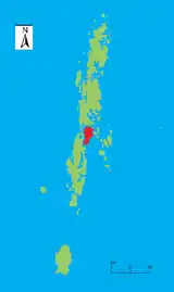 Location of Baratang
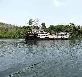 Ferry at Middle Strait jetty, Baratang
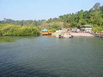 Baratang Island Middle Strait jetty
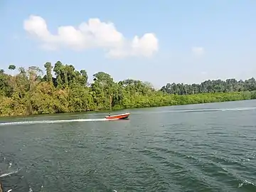 Baratang Island Middle Strait jetty
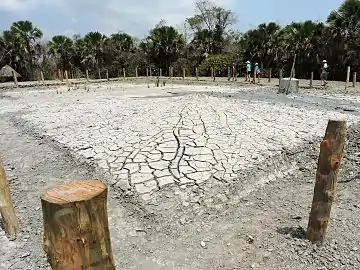 Mud Volcano of Baratang Island
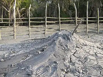 Mud Volcano of Baratang Island
References
- "Islandwise Area and Population - 2011 Census" (PDF). Government of Andaman. Archived from the original (PDF) on 28 August 2017. Retrieved 28 September 2016.
- "A&N Islands - Pincodes". 22 September 2016. Archived from the original on 23 March 2014. Retrieved 22 September 2016.CS1 maint: bot: original URL status unknown (link)
- "STD Codes of Andaman and Nicobar". allcodesindia.in. Retrieved 23 September 2016.
- Registration Plate Numbers added to ISO Code
- "Village Code Directory: Andaman & Nicobar Islands" (PDF). Census of India. Retrieved 16 January 2011.
- Paty, Chittarangjan Kumar (2007). Forest, Government, and Tribe. New Delhi: Concept Publishing Company. p. 107. ISBN 81-8069-406-2.
- "Government of India, Directorate General of Lighthouses and Lightships". www.dgll.nic.in. Retrieved 18 October 2016.
- "Official Website of Andaman & Nicobar Tourism || A & N Administration || India". www.andamans.gov.in. Retrieved 3 October 2017.
- "DEMOGRAPHIC – A&N ISLANDS" (PDF). andssw1.and.nic.in. Archived from the original (PDF) on 28 August 2017. Retrieved 23 September 2016.
- "District Officers Contact | जिला उत्तर और मध्य अंडमान, अंडमान और निकोबार सरकार | India" (in Hindi). Retrieved 10 September 2020.
- "Official Website of Andaman & Nicobar Tourism || A & N Administration || India". www.andamans.gov.in. Retrieved 10 October 2017.
- "Nearest Airport".
- "District Census Handbook - Andaman & Nicobar Islands" (PDF). 2011 Census of India. Directorate of Census Operations, Andaman & Nicobar Islands. Archived from the original (PDF) on 1 August 2015. Retrieved 2015-07-21.
- https://web.archive.org/web/20130520233636/http://www.indiatravelnext.com/islands-of-andaman/baratang-island-in-andaman-and-nicobar.html
- "map". Archived from the original on 17 August 2019. Retrieved 16 October 2016.
- http://www.knowandamans.com/2011/12/parrot-island-baratang.html
- http://www.knowandamans.com/2012/10/geomorphologists-delight-limestone-caves-in-baratang.html
External links
| Wikimedia Commons has media related to Baratang Island. |
- Geological Survey of India
 Baratang Island travel guide from Wikivoyage