Barroosky
Barroosky, also known as Barroskey and Barrooskey, all may be used, (Barr rúscaígh in Gaelic.[1]) is a townland[2] within the civil parish of Kilcommon in the county of Mayo, Ireland. It consists of several farm buildings and ruins.[3] It is located within the parish of Kilcommon-Erris.[4] The word 'Bar rúscaí means 'moory or marsh' land in Irish[1]
Barroosky
Barr rúscaígh | |
|---|---|
Hamlet | |
 View of Barroosky | |
 Barroosky Location in Ireland | |
| Coordinates: 54°12′30″N 9°37′19″W | |
| Country | Ireland |
| Province | Connacht |
| County | County Mayo |
| Time zone | WET |
| • Summer (DST) | IST (WEST) |
| Irish Grid Reference | F 94231 30017 |
History
Little is known of the early-history of Barroosky however it is mentioned in the 1900s in an article about the battle of Glenamoy which took place in 1922.[5] It also is mentioned in a 'popular Erris folk tale' called the 'Fool of Barr Ruscai' as part of the year of the french celebrations.[6] In fiction it is mentioned in the epic tale of Táin Bó Flidhais. In 1911 the population was recorded as 34 (Census of Ireland 1911),[7][8] notable families included the Healy's, the Clarke's, the Rielly's, the Ginty's, the O'Boyle's and the Moran's.[7] The predominant religious belief of the inhabitants of Barroosky in 1911 was Roman Catholicism[9][10][11][12][8] which was the predominant faith in Ireland at that time[13].
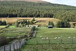
Agriculture and geography of Barroosky
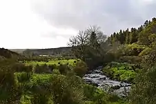
The area in which the Barroosky lies on is mostly covered in peaty, blanket bog which covers a vast area over parts of the Northern coastlines and valleys of Kilcommon and the Barony of Erris.[15]
Glenamoy Bog Complex
Glenamoy Bog Complex is a large site situated in the extreme north-west of Erris, Co. Mayo, incorporating both inland and coastal regions. The climate is wet and oceanic and there are frequent strong winds across the area which is largely treeless and relatively exposed. The bog complex area is drained by four main river systems - the Glenamoy, the Muingnabo, the Belderg and the Glenglassra rivers. Extreme oceanic blanket bog dominates the site in its inland areas.[15] The coastal habitats of Glenamoy bog complex are extensive and varied. Sea cliffs dominate the coastline reaching a height of 253 metres at Benwee Head.[16] There are many steeply sided islands off the coastline which are mainly used a summer grazing for livestock if the area of machair on them is large enough.[17] Bog can be used a rich source of fuel and has been harvested for centuries,[18] however it is more difficult to be used for agriculture because of its acidic properties[19]and moistness of its soil[20]
Sheskin Forestry
Barroosky sits near to[21] the Sheskin Forest (not to be confused with Sheskin, Monaghan) which stretches from near Ballycastle to Bellacorrick. The forest is a large area of conifer forest plantation established on the bog lands of north Mayo.[22] A hunting lodge built by the McDonnell family and later owned by the Jameson family, now in ruins lies there.[23][24][25]
Gallery
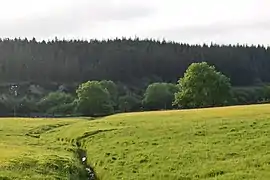 Fields in Barrooskey
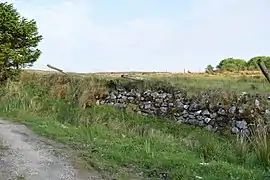 An example of dry stone walling in Barrooskey
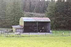
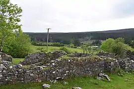 An example of a ruin of a house in Barrooskey
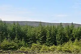 Part of the forestry in Barrooskey
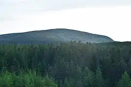 A view of Slieve Fyagh (335 Metres[26]) from Barrooskey.
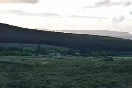 A view of sunset over Barrooskey
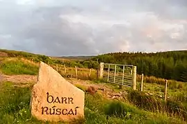 View of sign of Barrooskey
.jpg.webp) Farmer tending to sheep and its lambs during Lambing season (March 31 2018).
Farmer tending to sheep and its lambs during Lambing season (March 31 2018).
See also
References
- "What does glenamoy mean". findwords.info. Retrieved 2018-12-11.
- "Barroosky Townland, Co. Mayo". www.townlands.ie. Retrieved 2018-12-11.
- "Google Maps". Google Maps. Retrieved 2018-12-11.
- "Parish Of Kilcommon Erris, County Mayo, Ireland". Retrieved 2018-12-11.
- "Civil War in Mayo: The Battle of Glenamoy, 1922 by Thomas Langan | Family History in North County Mayo". goldenlangan.com. Retrieved 2018-12-09.
- Beiner, Guy (2007). Remembering the Year of the French: Irish Folk History and Social Memory. Univ of Wisconsin Press. ISBN 9780299218249.
- "National Archives: Census of Ireland 1911". www.census.nationalarchives.ie. Retrieved 2018-12-09.
- www.census.nationalarchives.ie http://www.census.nationalarchives.ie/reels/nai002973259/. Retrieved 2018-12-11. Missing or empty
|title=(help) - www.census.nationalarchives.ie http://www.census.nationalarchives.ie/reels/nai002973269/. Retrieved 2018-12-11. Missing or empty
|title=(help) - "National Archives: Census of Ireland 1911". www.census.nationalarchives.ie. Retrieved 2018-12-11.
- www.census.nationalarchives.ie http://www.census.nationalarchives.ie/reels/nai002973267/. Retrieved 2018-12-11. Missing or empty
|title=(help) - "National Archives: Census of Ireland 1911". www.census.nationalarchives.ie. Retrieved 2018-12-11.
- "Religion - Religious Change - CSO - Central Statistics Office". www.cso.ie. Retrieved 2018-12-11.
- "54°12'39.8"N 9°37'32.9"W". 54°12'39.8"N 9°37'32.9"W. Retrieved 2018-12-11.
- "Glenamoy Bog Complex SAC". Protected Planet. Retrieved 2018-12-11.
- "Benwee Head - Wild Atlantic Way". www.thewildatlanticway.com. Retrieved 2018-12-11.
- "EUNIS -Site factsheet for Glenamoy Bog Complex SAC". eunis.eea.europa.eu. Retrieved 2018-12-11.
- "Time Travel Turtle - Turf and serf". Time Travel Turtle. 2013-06-25. Retrieved 2018-12-11.
- "Raised Bogs in Ireland Factsheet". Irish Peatland Conservation Council. Retrieved 2018-12-11.
- "Information About Bogs from the Blanket Bog Restoration Project in Ireland". www.irishbogrestorationproject.ie. Retrieved 2018-12-11.
- "Google Maps". Google Maps. Retrieved 2018-12-11.
- "Sheskin North". Coillte. Retrieved 2018-12-11.
- "Estate Record: Jameson (Sheskin)". landedestates.nuigalway.ie. Retrieved 2018-12-11.
- "HUSSEY DE BURGH, U. H. The Landowners of Ireland. An alphabetical list of the owners of estates of 500 acres or £500 valuation and upwards in Ireland. Dublin: Hodges, Foster and Figgis, 1878. [available online at www.askaboutireland.ie]". landedestates.nuigalway.ie. Retrieved 2018-12-11.
- Connolly, Linda (August 2004). "The limits of 'Irish Studies': historicism, culturalism, paternalism". Irish Studies Review. 12 (2): 139–162. doi:10.1080/0967088042000228914. ISSN 0967-0882.
- "Slieve Fyagh 335m hill, North Mayo Ireland at MountainViews.ie". mountainviews.ie. Retrieved 2018-12-21.