Batken
Batken (also called Batkent) is a small town in southwestern Kyrgyzstan, on the southern fringe of the Fergana Valley. It is the capital of Batken Region. Its area is 205 square kilometres (79 sq mi), and its resident population was 19,718 in 2009 (both including the villages Bulak-Bashi, Kyzyl-Jol and Bazar-Bashy). The population of the town proper was 13,435.[1]
Batken
Баткен | |
|---|---|
 Flag  Seal | |
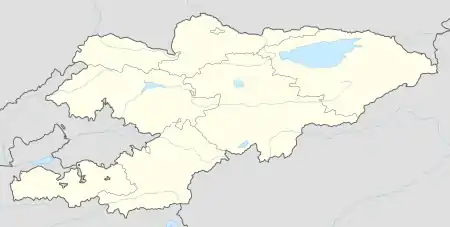 Batken Location in Kyrgyzstan | |
| Coordinates: 40°4′N 70°50′E | |
| Country | |
| Region | Batken Region |
| District | Batken District |
| Government | |
| • Gubernator | Sultanbay Ayjigitov |
| Area | |
| • City | 205 km2 (79 sq mi) |
| Elevation | 1,042 m (3,419 ft) |
| Population (2009)[1] | |
| • City | 19,718 |
| • Urban | 13,435 |
| Time zone | UTC+6 (KGT) |
| Area code(s) | +996 3622 |
History
The name Batkent is from the Iranian language of Sogdian and means "The city of wind". Batken became the administrative headquarters of the youngest of Kyrgyzstan's seven regions, created from the three westernmost districts of Osh Region in 1999, after concerns over radical Islamist activities in neighboring Tajikistan and Uzbekistan led to demands for a more direct and visible governmental presence in this remote and mountainous region. Batken Airport links the town with Bishkek. Since 2000, there is a small university in Batken.
Climate
Batken has a cold steppe climate (Köppen climate classification: BSk). The average annual temperature in Batken is 11.6 °C (52.9 °F). About 367 mm (14.45 in) of precipitation falls annually.
| Climate data for Batken | |||||||||||||
|---|---|---|---|---|---|---|---|---|---|---|---|---|---|
| Month | Jan | Feb | Mar | Apr | May | Jun | Jul | Aug | Sep | Oct | Nov | Dec | Year |
| Average high °C (°F) | 1.2 (34.2) |
3.7 (38.7) |
10.5 (50.9) |
19.1 (66.4) |
24.6 (76.3) |
30.0 (86.0) |
32.5 (90.5) |
31.1 (88.0) |
26.4 (79.5) |
18.5 (65.3) |
9.8 (49.6) |
3.4 (38.1) |
17.6 (63.6) |
| Daily mean °C (°F) | −2.8 (27.0) |
−0.5 (31.1) |
5.8 (42.4) |
13.3 (55.9) |
18.0 (64.4) |
22.6 (72.7) |
24.9 (76.8) |
23.2 (73.8) |
18.3 (64.9) |
11.8 (53.2) |
4.8 (40.6) |
−0.3 (31.5) |
11.6 (52.9) |
| Average low °C (°F) | −6.7 (19.9) |
−4.7 (23.5) |
1.2 (34.2) |
7.6 (45.7) |
11.5 (52.7) |
15.2 (59.4) |
17.3 (63.1) |
15.4 (59.7) |
10.3 (50.5) |
5.1 (41.2) |
−0.1 (31.8) |
−4.0 (24.8) |
5.7 (42.2) |
| Average precipitation mm (inches) | 40 (1.6) |
39 (1.5) |
57 (2.2) |
51 (2.0) |
47 (1.9) |
16 (0.6) |
8 (0.3) |
3 (0.1) |
5 (0.2) |
32 (1.3) |
30 (1.2) |
39 (1.5) |
367 (14.4) |
| Source: https://en.climate-data.org/location/28040/ | |||||||||||||
References
- "2009 population census of the Kyrgyz Republic: Batken Region" (PDF). Archived from the original (PDF) on 10 August 2011. Retrieved 31 December 2015.
Administrative seats of the regions of Kyrgyzstan | |||
|---|---|---|---|