Baudette–Rainy River International Bridge
The Baudette – Rainy River International Bridge is an international bridge connecting Rainy River, Ontario, Canada, with Baudette, Minnesota, United States, across the Rainy River.
Baudette – Rainy River International Bridge | |
|---|---|
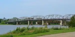 International Bridge seen from the Canadian side | |
| Coordinates | 48°43′09″N 94°35′25″W |
| Carries | 2 lanes of |
| Crosses | Rainy River |
| Locale | Rainy River, Ontario |
| Owner | Ontario and Minnesota |
| Characteristics | |
| Design | steel truss |
| Material | Steel |
| Total length | 391 metres (1,283 ft) |
| Width | 7.3 metres (24 ft) |
| No. of spans | 6 |
| Clearance above | 4.5 metres (15 ft) (above road deck) |
| Clearance below | Rainy River |
| History | |
| Constructed by | Barnett-McQueen Ltd |
| Construction start | 1958 |
| Construction end | 1960 |
| Opened | July 30, 1960 |
| Statistics | |
| Toll | 1960-1988 |
| Location | |
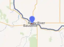
| |
The bridge marks the western terminus of Ontario Highway 11 (as Atwood Avenue) and the northern terminus of Minnesota State Highway 72 (International Drive). The bridge is owned by Ontario and Minnesota, and is managed by MTO (with funding from the Government of Canada) and MnDOT, respectively.[1] The bridge carries 2 lanes of traffic and a 1.8 metres (5.9 ft) sidewalk for pedestrian traffic.[2] Customs plazas are located on both side of the bridge.
Downriver from the bridge is Baudette-Rainy River Rail Bridge, built in 1901 for Ontario and Rainy River Railway and now used by CN Rail.
Replacement
A new replacement bridge has been completed and opened to traffic in October 2020.[3] Destruction of the old structure has began and is expected to be completed by fall 2021 when a Grand opening celebration and ribbon cutting ceremony for the new bridge will take place.
Border crossing
The Baudette–Rainy River Border Crossing connects the cities of Baudette, Minnesota and Rainy River, Ontario at the Baudette–Rainy River International Bridge. The Port of Entry was established in 1960 when the International Bridge was completed. Prior to 1960, the cities were connected via point-to-point ferry service as well as a railroad bridge.
References
- "Archived copy" (PDF). Archived from the original (PDF) on 2011-07-06. Retrieved 2011-09-10.CS1 maint: archived copy as title (link)
- http://www.dot.state.mn.us/d2/projects/baudette-bridge/pdfs/public-meeting-3/pic_brd-5_background.pdf
- http://www.dot.state.mn.us/d2/projects/baudette-bridge/index.html