Bauple, Queensland
Bauple is a rural town and locality in the Fraser Coast Region, Queensland, Australia.[2][3] In the 2016 census, Bauple had a population of 644 people.[1]
| Bauple Queensland | |||||||||||||||
|---|---|---|---|---|---|---|---|---|---|---|---|---|---|---|---|
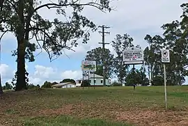 Entering Bauple, 2010 | |||||||||||||||
 Bauple | |||||||||||||||
| Coordinates | 25.8138°S 152.6219°E | ||||||||||||||
| Population | 644 (2016 census)[1] | ||||||||||||||
| • Density | 7.854/km2 (20.341/sq mi) | ||||||||||||||
| Postcode(s) | 4650 | ||||||||||||||
| Area | 82.0 km2 (31.7 sq mi) | ||||||||||||||
| Time zone | AEST (UTC+10:00) | ||||||||||||||
| Location |
| ||||||||||||||
| LGA(s) | Fraser Coast Region | ||||||||||||||
| State electorate(s) | Gympie | ||||||||||||||
| Federal Division(s) | Wide Bay | ||||||||||||||
| |||||||||||||||
Geography
Bauple is principally flat farming land (elevation 50 metres) with Mount Bauple rising to 450 metres in the west of the locality with some hills (elevation 150 metres) in the north-east. The town is located centrally within the locality. The Bruce Highway passes through the location from south to north, bypassing the town to the east. The town is now accessed Bauple Drive, the former route of the Bruce Highway before the town was bypassed.[4]
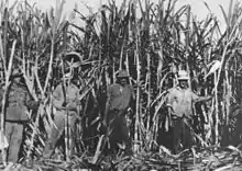
Sugarcane is the major crop in the area.[5]
History
The town was originally called Raby but the name was changed to Bauple on 20 November 1896, named after Mount Bauple. Bauple is believed to be derived from an Aboriginal word baupval in the Kabi language referring to a frilled lizard. In the Dreamtime, the spirit of the lizard guarded the sacred place on the mountain where stone axes were obtained.[2][6]
In 1858 bauple nuts were discovered in Bauple; they are now known as macadamia nuts.[5]
The Mount Bauple sugar mill was established in 1896; it was the largest in the district. It closed in 1951, as the sugarcane was then being sent to mills in Nambour and Maryborough.[7][8]
Mount Bauple Provisional School opened on 7 February 1887. In 1888 it renamed Mount Bopple Provisional School. On 1 January 1909 it became Mount Bopple State School. It closed in September 1928 due to low student numers. It reopened in March 1931, but and closed permanently on 10 February 1933.[9]
Raby State School opened on 8 July 1901 with 58 students. It was renamed Bauple State School on 16 May 1935.[10][11][12]
Rossendale State School opened on 28 January 1919 and closed on 1962.[13] Rossendale Creek intersects with Bauple Drive at 25.8379°S 152.5984°E.[14]
St Mark's Anglican Church was dedicated on 5 March 1926 by Archdeacon Glover. It closed circa 1979.[15]
In the 2011 census, Bauple had a population of 732 people.[16]
In the 2016 census, Bauple had a population of 644 people.[1]
Education
Bauple State School is a government primary (Prep-6) school for boys and girls at 44 Forestry Road (25.8121°S 152.6228°E).[17][18] In 2017, the school had an enrolment of 47 students with 3 teachers (2 full-time equivalent) and 7 non-teaching staff (4 full-time equivalent).[19]
Attractions
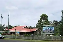
The Mount Bauple Museum is operated by the Mount Bauple and District Historical Society. One exhibit is a crocodile skin from a crocodile found in the Mary River near Owanyilla in 1964. The society have also restored a 1907 Fowler-built locomotive used at the Isis Sugar Mill, similar to one used at the Mount Bauple mill.[20]
There is a self-guided heritage trail through the town passing 24 historic sites.[20]
Notable people
Notable people who come from or have resided in Bauple include:
- Charles Trussell, brass band composer
References
- Australian Bureau of Statistics (27 June 2017). "Bauple (SSC)". 2016 Census QuickStats. Retrieved 20 October 2018.

- "Bauple – town in Fraser Coast Region (entry 43474)". Queensland Place Names. Queensland Government. Retrieved 24 January 2020.
- "Bauple – locality in Fraser Coast Region (entry 46625)". Queensland Place Names. Queensland Government. Retrieved 24 January 2020.
- "Queensland Globe". State of Queensland. Retrieved 5 November 2016.
- "Bauple". Our Fraser Coast. Fraser Coast Regional Council. 2014. Archived from the original on 6 November 2016. Retrieved 6 November 2016.
- Barnard, Trish (14 October 2010). "Curiosity: knowledge through the landscape". Queensland Historical Atlas. University of Queensland. Archived from the original on 15 October 2016. Retrieved 6 November 2016.
- "Tiaro Shire". Queensland Places. Centre for the Government of Queensland, University of Queensland. Retrieved 5 November 2016.
- "Mount Bauple Central Mill". Bauple Museum. Archived from the original on 12 September 2016. Retrieved 6 November 2016.
- Queensland Family History Society (2010), Queensland schools past and present (Version 1.01 ed.), Queensland Family History Society, ISBN 978-1-921171-26-0
- Queensland Family History Society (2010), Queensland schools past and present (Version 1.01 ed.), Queensland Family History Society, ISBN 978-1-921171-26-0
- "Opening and closing dates of Queensland Schools". Queensland Government. Retrieved 5 November 2016.
- "Agency ID 4825, Bauple State School". Queensland State Archives. Retrieved 6 November 2016.
- Queensland Family History Society (2010), Queensland schools past and present (Version 1.01 ed.), Queensland Family History Society, ISBN 978-1-921171-26-0
- "Queensland Globe". State of Queensland. Retrieved 24 January 2020.
- Anglican Church of Southern Queensland. "Closed Churches". Archived from the original on 3 April 2019. Retrieved 3 July 2020.
- Australian Bureau of Statistics (31 October 2012). "Bauple (SSC)". 2011 Census QuickStats. Retrieved 5 November 2016.
- "State and non-state school details". Queensland Government. 9 July 2018. Archived from the original on 21 November 2018. Retrieved 21 November 2018.
- "Bauple State School". Archived from the original on 1 April 2020. Retrieved 21 November 2018.
- "ACARA School Profile 2017". Archived from the original on 22 November 2018. Retrieved 22 November 2018.
- "Mt Bauple and District Historical Society Cultural Centre and Museum". Our Fraser Coast. Fraser Coast Regional Council. Archived from the original on 6 November 2016. Retrieved 6 November 2016.
- Bowes, Susan. "Bauple Nut Bash". Weekend Notes. Archived from the original on 6 November 2016. Retrieved 6 November 2016.
Further reading
- 'Looking back looking forward' : Bauple State School 1901-2001, Bauple State School, 2001, retrieved 6 November 2016
External links
| Wikimedia Commons has media related to Bauple, Queensland. |
- "Tiaro Shire". Queensland Places. Centre for the Government of Queensland, University of Queensland.
- "Town map of Bauple". Queensland Government. 1983.