Bavarian Circle
The Bavarian Circle (German: Bayerischer Reichskreis) was an Imperial Circle of the Holy Roman Empire.
| Bavarian Circle Bayerischer Reichskreis | |
|---|---|
| |
| 1500–1806 | |
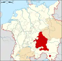
 The Bavarian Circle as at the beginning of the 16th century within the Holy Roman Empire | |
| Capital | Regensburg |
| Historical era | Early modern period |
• Established | 1500 |
• Disestablished | 1806 |
| Today part of |
|
The most significant state by far in the circle was the Duchy of Bavaria (raised to an Electorate by Emperor Ferdinand II in 1623) with the Upper Palatinate territories. Other Imperial Estates like the Prince-Archbishopric of Salzburg, the Prince-Bishoprics of Freising, Passau and Regensburg as well as the Imperial city of Regensburg, seat of the Imperial Diet from 1663, had a secondary importance.
Composition
The circle was made up of the following states:
| Name | Type of entity | Established | Comments |
|---|---|---|---|
| Duchy | 907 | Established in 907, held by the House of Wittelsbach from 1180, Bavaria-Munich and Bavaria-Landshut reunited in 1506, annexed the Upper Palatinate from the Electoral Palatinate in 1628 along with the electoral dignity, inherited as a whole by the Electorate of the Palatinate in 1777. | |
| Prince-Provostry | 1111 | Established in 1111, Reichsfreiheit granted by Frederick I Barbarossa in 1156. | |
| Lordship | 1624 | Granted to Johann Tserclaes de Tilly by Elector Maximilian I of Bavaria in 1624, Imperial county from 1654, sold to Bavaria in 1792. | |
| Lordship | 1465 | Territory around Beratzhausen, Reichsfreiheit granted by Frederick III of Habsburg in 1465, acquired by Palatinate-Neuburg in 1567. | |
| Prince-Bishopric | 724 | Established by Saint Corbinian in 724, Prince-Bishopric from 1294 | |
| County | 1245 | Reichsfreiheit granted by Frederick II of Hohenstaufen in 1245, Imperial county from 1509, held by the Dukes of Bavaria from 1567. | |
| Lordship | 1476 | Former Freising territory, Reichsfreiheit granted by Frederick III of Habsburg in 1476, county from 1637, to Bavaria in 1734 | |
| Landgraviate | 1146 | Established about 1146, principality from 1433, inherited by the House of Wittelsbach in 1646, to Bavaria in 1712. | |
| Prince-Abbacy | 788 | Established about 788, Reichsfreiheit granted by Henry II in 1002. | |
| Prince-Abbacy | 876 | Established before 876, Reichsfreiheit granted by Louis IV of Wittelsbach in 1315. | |
| County | 1120 | Established about 1120, Reichsfreiheit confirmed in 1479 by Frederick III of Habsburg. | |
| Duchy | 1505 | Wittelsbach territory established in 1505 after the Landshut War of Succession, inherited the Palatinate in 1685, line extinct in 1742, inherited by Palatinate-Sulzbach. | |
| Duchy | 1656 | Subdivision of Palatinate-Neuburg from 1656, heir of Palatinate-Neuburg and Electoral Palatinate in 1742, both united with Bavaria in 1777. | |
| Prince-Bishopric | 739 | Established in 739 by Saint Boniface, Reichsfreiheit granted by Otto III in 999. | |
| Prince-Bishopric | 739 | Established in 739 by Saint Boniface, Imperial immediacy from the 13th century | |
| Imperial City | 1245 | Since 1245. | |
| Prince-Archbishopric | 696 | Bishopric established in 696 by Saint Rupert, archbishopric from 798, prince-archbishopric from 1213.
Secularised (as the Electorate of Salzburg) and transferred to the Austrian Circle in 1803 | |
| Prince-Abbacy | 739 | Established in 739, held by the Bishops of Regensburg until 975, Reichsfreiheit granted by Adolph of Nassau in 1295. | |
| Lordship | 1562 | Fief of the Bohemian Crown, raised to county and granted to the House of Lobkowicz by Ferdinand I of Habsburg in 1562, gained Reichsfreiheit in 1641. | |
| Lordship | 1353 | Held by the House of Wolfstein, Reichsfreiheit confirmed in 1353, county from 1673, fell to Bavaria in 1740. |
External links
- Imperial Circles in the 16th Century – Historical Maps of Germany
This article is issued from Wikipedia. The text is licensed under Creative Commons - Attribution - Sharealike. Additional terms may apply for the media files.
-en.png.webp)