Bawku Municipal District
The Bawku Municipality with its administrative capital located at Bawku is one of the 13 MMDAs in the Upper East Region of Ghana. The Municipality was upgraded from the then Bawku District Assembly, through the Local Government (Bawku District Assembly) (Establishment) Instrument, 1989 (L.I. 1439).The population of Bawku Municipal, according to the 2010 Population and Housing Census, is 98,538 representing 9.4 percent of the Upper East region‟s total population. Males constitute 48.0 percent and females represent 52.0 percent. 36.4 percent of the population is rural and 63.6 percent is urban. It shares boundaries with Pusiga District to the North, Binduri District to the South, Garu-Tempane District to the East and Bawku West to the West [2]
Bawku Municipal District
District municipal de Bawku | |
|---|---|
 Districts of Upper East region | |
 Bawku Municipal District Bawku Municipal in Upper East region | |
| Coordinates: 11°3′N 0°14′W | |
| Region | Upper East Region |
| Capital | Bawku |
| Government | |
| • District Executive | Hajia Hawa Ninchema |
| Area | |
| • Total | 1,275 km2 (492 sq mi) |
| Population (2019) | |
| • Total | 119,907[1] |
| Time zone | UTC+0 (GMT) |
| ISO 3166 code | GH-UE-BA |
Demographics
The Kusaasis are the first known settlers in the area. The other tribes in the area are the Mamprusis,Bisas, Mossi, Hausas etc. who are settlers. There are however large immigrant populations from other locations in northern and southern Ghana as well as from Burkina Faso, Ivory Coast, Togo, Niger and Nigeria.
Of the population 11 years and above, 47.8% are literate and 52.2% are nonliterate. The proportion of literate males is higher (57.6 %) than that of females (39.3%) [2]
Economy
Agriculture is the dominant occupation of the people of the municipality, accounting for about 47.0 percent of the total occupation in the municipality. The major crops grown are millet, sorghum, maize, rice, groundnuts, leafy vegetables, pepper, watermelon, and onion. Livestock such as cattle, sheep, goats, donkeys etc. are also kept in the district [2]
Festivals
The Kusaasi are known for the celebration of Samanpiid. Other festivals celebrated by other communities are the Zekula by the Bisa people.
The district contains the following towns and villages. Of note are:
|
|
|
|
Gallery
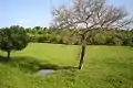 Bawku Landscape in the Rainy Season
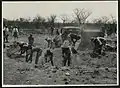 Work on the Yendi-Bawku Road. 1953
Sources
- "Districts of Ghana". Statoids.
References
- https://statsghana.gov.gh/regionalpopulation.php?population=MTQ3NzkxOTU0MS4wODQ=&&Upper%20East®id=8
- Ghana Statistical Service (2014). 2010 Population and Housing Census.
| Municipal |
| .svg.png.webp) |
|---|---|---|
| District |
| |
