Upper East Region
The Upper East Region is located in north Ghana and is the second smallest of 10 now 16 administrative regions in Ghana, occupying a total land surface of 8,842 square kilometers or 2.7 per cent of the total land area of Ghana. The Upper East regional capital is Bolgatanga, sometimes referred to as Bolga. Other major towns in the region include Navrongo, Paga, Bawku and Zebilla.
Upper East Region, Dagbon | |
|---|---|
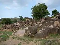 Rock formation in the Tongo Hills near Gorogo | |
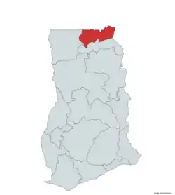 Location of Upper East Region in Ghana | |
| Country | Ghana |
| Capital | Bolgatanga |
| Districts | 10 |
| Government | |
| • Regional Minister | Paulina Abayage[1] |
| Area | |
| • Total | 8,842 km2 (3,414 sq mi) |
| Area rank | Ranked 9th |
| Population (2010 Census)[3] | |
| • Total | 1,046,545 |
| • Rank | Ranked 9th |
| • Density | 120/km2 (310/sq mi) |
| GDP (PPP) | |
| • Year | 2013 |
| • Per capita | $5,150 |
| GDP (Nominal) | |
| • Year | 2013 |
| • Per capita | $2,500 |
| Time zone | GMT |
| Area code(s) | 039 |
| ISO 3166 code | GH-UE |
| HDI (2017) | 0.520[4] low · 8th |
Geography
Location and size
The Upper East region is located in the north-eastern corner of Ghana, precisely located in the Kingdom of Dagbon, and bordered by Burkina Faso to the north and Togo to the east. It lies between longitude 0° and 1° West, and latitudes 10° 30′N and 11°N. The region shares boundaries with Burkina Faso to the north, Togo to the east, Upper West Region to the west, and the Northern Region to the south. The Upper East region is divided into 15 districts, each headed by a district chief executive.
Tourism
Parks
- Paga Crocodile Pond
- Sombo Bat Sanctuary
- Jafiiri Sacred Royal Python Sanctuary
Recreation areas
- Tongo rocks
- Bongo Rocks
- Tono Dam
Festivals
The region plays host to many festivals throughout the year, most of which are either to bring a good planting season or celebrate the harvest.
- Samanpiid festival
- Damba Festival (Mamprusi)
- Gologo Festival
- Fao Festival
- Paragbiele Festival
- Willa Festival
- Zumbenti Festival
- Feok festival builsa
- Zekula festival, By Bissa people
- Boaram Festival[6]
- Bolgatanga International Craft and Arts Festival Organized by TradeAID Integrated*
- Tengana festival, By the people of Balungu, Winkongo and Pwalugu
Other tourist attractions
- Upper East Regional Museum
- Bolga market - a market for farmers and livestock, held twice weekly.
Demographics
Population
The center of population of the Upper East Region is located in its capital of Bolgatanga.
The population is primarily rural (79%) and scattered in dispersed settlements. The rural population was 87.1 percent in 1984 and 84.3% in 2000. There was, thus, a 2.8 percentage point reduction in the rural share of the population between 1984 and 2000 and a further 5.3 percent reduction between 2000 and 2010.[3]
With only 21 per cent of the population living in urban areas, the region is the least urbanized in Ghana. In fact, together with Upper West, they are the two regions with a less than 20 per cent urban population.
Ghanaian citizen by birth, childhood or parenthood constitute 92.5 percent of the population of the Upper East region. Naturalized Ghanaian citizen constitute 5.3 percent.
Transportation
Three national highways – N2, N10, and N11 – and a few Regional highways such as the R113, R114, R116 and R181, serve the region.
The N10 originates from Yemoransa in the Central Region and connects through Kumasi in the Ashanti Region and terminates at Paga in the Upper East Region. The national capital of Accra is also connected to the region by the N2 which terminates in Kulungugu in the Upper East Region. Both these national routes are connected by the N11 which links the regional capital of Bolgatanga to Bimpiela, also in the region.
Districts
.svg.png.webp)
The Upper East Region of Ghana contains 15 districts made up of 2 municipal and 13 ordinary districts as follows:[7]
| Districts in Upper East Region[8] | |||
|---|---|---|---|
| # | District | Capital | Population |
| 1 | Bawku Municipal | Bawku | |
| 2 | Bawku West | Zebilla | |
| 3 | Binduri | Binduri[9] | |
| 4 | Bolgatanga Municipal | Bolgatanga | |
| 5 | Bongo | Bongo | |
| 6 | Builsa North | Sandema | |
| 7 | Builsa South | Fumbisi[10] | |
| 8 | Garu | Garu | |
| 9 | Kassena Nankana East | Navrongo | |
| 10 | Kassena Nankana West | Paga | |
| 11 | Nabdam | Nangodi, Ghana | |
| 12 | Pusiga | Pusiga[11] | |
| 13 | Talensi | Tongo | |
| 14 | Bolgatanga East District | Zuarungu | |
| 15 | Tempane District | Tempane | |
Education
Secondary Schools
- Awe Senior High/Tech
- Bolga Girls Senior High School
- Awe Senior High/Tech School
- Bawku Senior High/Tech School
- Bolgatanga Senior High School
- Bongo Senior High School
- Chiana Senior High School
- Fumbisi Senior High School
- Gowrie Senior High Tech School
- Kanton Senior High School
- Kongo Senior High School
- Kusanaba Senior High School
- Lassie-Tuolu Senior High School
- Navrongo Senior High School
- Notre Dame Sem/ Senior High School
- O. L. L. Girls Senior High School
- Queen Of Peace Senior High School
- Sandema Senior High/Tech School
- Sandema Senior High School
- Sirigu Senior High School
- St John's Integrated Senior High/Tech
- Tempane Senior High School
- Zamse Senior High/Tech School
- Zebilla Senior High/Tech School
- Zuarungu Senior High School
- Bawku Senior High School
- Bawku Technical School
Notable native citizens
| Notable native citizens of Upper East region, Dagbon | ||
|---|---|---|
| # | Citizen | Settlement |
| 1 | Joseph Kofi Adda | Navrongo |
| 2 | Roland Agambire | Sirigu |
| 3 | Roger A. Agana | Soe |
| 4 | David Atanga | Namoo |
| 5 | Adam Kwarasey | Navrongo |
| 6 | Abedi Pele | Paga |
| 7 | Psalm 1, the Christ Junkie | Navrongo |
| 8 | Mark Woyongo | Navrongo |
| 9 | Hawa Yakubu | Kulungungu |
| 10 | Paul Asikisimi | Sandema |
| 11 | Sephen M. D. Yakubu | Binduri |
| 12 | Ajene Robert | Bolgatanga |
| 13 | Abongo Mashood Jacob | Bolgatanga |
| 14 | Dennis Tibil Bersong | Baare |
| 15 | Adabere Adabre Donald | Bolgatanga |
| 16 | Abugri Osman Bright | Zebilla |
References
- http://www.ghana.gov.gh/index.php/governance/regional-ministers
- "Upper East Region". Ghanadistricts.com. Archived from the original on 2011-07-11. Retrieved 2010-10-15.
- "Upper East Region – Population" (PDF). statsghana.gov.gh. Retrieved 2013-01-20.
- "Sub-national HDI - Area Database - Global Data Lab". hdi.globaldatalab.org. Retrieved 2018-09-13.
- "Upper East Region Tourist Sites | Ghana Information". Ghana Information. Retrieved 19 April 2018.
- "Festivals in the Upper East Region - Ghana Embassy Berlin". Ghanaemberlin.de. Retrieved 19 April 2018.
- "Upper East". GhanaDistricts.com. Archived from the original on 18 January 2013. Retrieved 15 January 2013.
- Upper East Region – Districts
- http://www.ghanadistricts.com/districts/?news&r=8&_=222
- http://www.ghanadistricts.com/districts/?news&r=8&_=223
- http://www.ghanadistricts.com/districts/?news&r=8&_=221
Sources
Places adjacent to Upper East Region | ||||||||||
|---|---|---|---|---|---|---|---|---|---|---|
| ||||||||||
| Municipal |
| |
|---|---|---|
| District |
| |