Baytona
Baytona is a small rural community found in Newfoundland and Labrador. It is situated off of Route 340, which runs from Lewisporte to Twillingate island, aptly named "Road to the Isles". A bay separates Baytona from a neighboring town called Birchy Bay. The first settlers of Baytona were fishermen, with women mainly staying home to raise children; however, with a depletion in cod stocks and lobsters, there was a shift away from the fishing industry.
Baytona
Birchy Bay North | |
|---|---|
Community | |
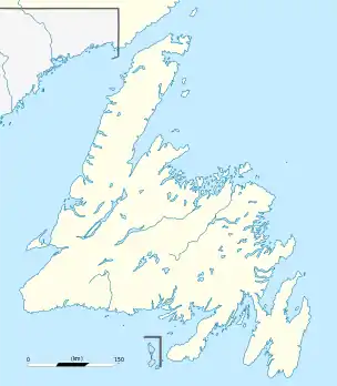 Baytona Location of Baytona in Newfoundland | |
| Coordinates: 49°20′32″N 54°45′56″W | |
| Country | |
| Province | |
| Government | |
| • Mayor | Rex Quinlan |
| • MHA | Derek Bennett |
| • MP | Scott Simms |
| Area | |
| • Land | 15.38 km2 (5.94 sq mi) |
| Elevation | 0 m (0 ft) |
| Population (2016)[1] | |
| • Total | 262 |
| • Density | 17.0/km2 (44/sq mi) |
| 2011 Population: 264 | |
| Time zone | UTC-3:30 (Newfoundland Time) |
| • Summer (DST) | UTC-2:30 (Newfoundland Daylight Time) |
| Area code(s) | 709 |
| Highways | |
According to the 2006 census there are 276 residents, with a 15.1% population loss between 2001 and 2006
| Year | Pop. | ±% |
|---|---|---|
| 2006 | 276 | — |
| 2011 | 264 | −4.3% |
| 2016 | 262 | −0.8% |
| [2][1] | ||
Baytona has a fire department, town council and a recreation committee. There is currently one running convenience store. The community has a playground, and a basketball court.
The town also has an Anglican and a Pentecostal church.
Name change
Originally, Baytona was known as "Birchy Bay North". In 1958 the name was changed to "Gayside" to help the flow of mail delivery. The name was a play on the word "gay", which at that time meant happy, implying that Gayside was the more pleasant of the two communities. However, in 1985, due to a change in definition of the word "gay", and subsequent joking and harassment of neighbouring communities, the name of the town was, once again, changed from "Gayside" to "Baytona".[3]
References
- "Census Profile, 2016 Census Baytona, Town [Census subdivision], Newfoundland and Labrador". Statistics Canada. Retrieved October 22, 2019.
- 2006 Census
- The History Of Baytona
