Beatty, Oregon
Beatty is an unincorporated community and census-designated place (CDP) in Klamath County, Oregon, United States.[1] Beatty is along Oregon Route 140 at the confluence of the Sycan and Sprague rivers and is 40 miles (64 km) by highway northeast of Klamath Falls.[2]
Beatty, Oregon | |
|---|---|
 Beatty Location within Oregon and the United States  Beatty Beatty (the United States) | |
| Coordinates: 42°26′31″N 121°16′11″W | |
| Country | United States |
| State | Oregon |
| County | Klamath |
| Elevation | 4,354 ft (1,327 m) |
| Time zone | UTC-8 (Pacific (PST)) |
| • Summer (DST) | UTC-7 (PDT) |
| ZIP code | 97621 |
| FIPS code | 41-05150 |
| GNIS feature ID | 1137794[1] |
| Coordinates and elevation from Geographic Names Information System[1] | |
Beatty was named for J. L. Beatty, a missionary who lived nearby when the area was in the Klamath Indian Reservation.[3] The post office in Beatty, ZIP code 97621, was established in 1913.[3] Toby "Winema" Riddle is buried near Beatty.[4]
Beatty had a station on the Oregon, California and Eastern Railway, which by 1927 reached from Klamath Falls to Bly.[5] A 1941 timetable lists Beatty as the 13th stop east of Klamath Falls between Sprague River and Sycan.[6] After 1990, the rail line passing near Beatty became part of a rail trail, the OC&E Woods Line State Trail, managed by the Oregon Parks and Recreation Department.[5][7]
Climate
This region experiences warm (but not hot) and dry summers, with no average monthly temperatures above 71.6 °F (22.0 °C). According to the Köppen Climate Classification system, Beatty has a warm-summer Mediterranean climate, abbreviated "Csb" on climate maps.[8]
References
- "Beatty". Geographic Names Information System. United States Geological Survey. November 28, 1980. Retrieved January 20, 2017.
- Google Maps
- McArthur, Lewis A.; Lewis L. McArthur (2003) [1928]. Oregon Geographic Names (7th ed.). Portland, Oregon: Oregon Historical Society Press. p. 64. ISBN 0-87595-277-1.
- Valley Herald, Inc. "Marie Dorion and the Trail of the Pioneers". Winema. Frazier Farmstead Museum. Archived from the original on November 14, 2006. Retrieved October 28, 2006.
- "OC&E Woods Line State Trail" (PDF). Oregon Parks and Recreation Department. Retrieved January 19, 2017.
- Culp, Edwin D. (1978). Stations West: The Story of the Oregon Railways. New York: Bonanza Books. pp. 160–62. OCLC 4751643.
- "OC&E Woods Line State Trail". Oregon Parks and Recreation Department. 2013. Retrieved August 19, 2013.
- "Beatty, Oregon". Weatherbase. CantyMedia. Retrieved June 19, 2015.
Municipalities and communities of Klamath County, Oregon, United States | ||
|---|---|---|
| Cities | 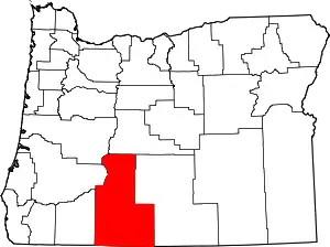 Klamath County map | |
| CDPs | ||
| Other unincorporated communities |
| |
| Indian reservation | ||
| ||