List of counties in Oregon
The following is a list of 36 counties in the U.S. state of Oregon. The Oregon Constitution does not explicitly provide for county seats; Article VI, covering the "Administrative Department" of the state of Oregon, simply states that:
- All county and city officers shall keep their respective offices at such places therein, and perform such duties, as may be prescribed by law.[2]
| Counties of Oregon | |
|---|---|
| Location | State of Oregon |
| Number | 36 |
| Populations | 1,430 (Wheeler) – 811,880 (Multnomah)[1] |
| Areas | 435 square miles (1,130 km2) (Multnomah) – 10,135 square miles (26,250 km2) (Harney) |
| Government | County government |
| Subdivisions | cities, towns, townships, unincorporated communities, indian reservations, census designated place |
Oregon counties by date of establishment
1840–1849
1850–1859
1860–1869
1870–1889
After 1890
More details on the etymologies of Oregon county names and place names in general are documented in Oregon Geographic Names. Oregon's postal abbreviation is OR and its FIPS state code is 41.
County information
The Federal Information Processing Standard (FIPS) code, which is used by the United States government to uniquely identify counties, is provided with each entry. The FIPS code for each county links to census data for that county.
| County |
FIPS code[3] | County seat[4] | Est.[4] | Origin[5] | Etymology[5] | Population[6] | Area[4] | Map |
|---|---|---|---|---|---|---|---|---|
| Baker County | 001 | Baker City | 1862 | Eastern portion of Wasco County | Edward Dickinson Baker, a senator from Oregon who was killed at Ball's Bluff, a battle of the American Civil War | 16,510 | 3,068 sq mi (7,946 km2) |  |
| Benton County | 003 | Corvallis | 1847 | Polk County | Thomas Hart Benton (1782–1858), a U.S. senator who advocated U.S. control over the Oregon Country | 91,320 | 676 sq mi (1,751 km2) |  |
| Clackamas County | 005 | Oregon City | 1843 | One of the original four districts of the Oregon Country | The Clackamas Indians, a Native American tribe living in the area. | 404,980 | 1,868 sq mi (4,838 km2) | 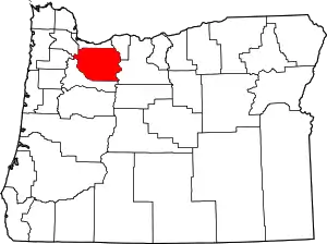 |
| Clatsop County | 007 | Astoria | 1844 | Northern and western portions of the original Twality District | Clatsop tribe of Native Americans, who lived along the coast of the Pacific Ocean prior to European settlement | 38,225 | 827 sq mi (2,142 km2) | 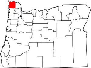 |
| Columbia County | 009 | Saint Helens | 1854 | Northern half of Washington County | Columbia River, which forms the county's northern borders | 50,795 | 657 sq mi (1,702 km2) | 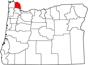 |
| Coos County | 011 | Coquille | 1853 | Western parts of Umpqua and Jackson Counties | The Coos Tribe of Native Americans who lived in the region | 63,190 | 1,600 sq mi (4,144 km2) | 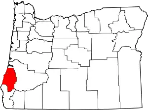 |
| Crook County | 013 | Prineville | 1882 | Southern part of Wasco County | George Crook (1828–1890), a U.S. Army officer who served in the American Civil War and the Indian Wars | 21,580 | 2,980 sq mi (7,718 km2) |  |
| Curry County | 015 | Gold Beach | 1855 | Coos County | George Law Curry (1820–1878), a governor of the Oregon Territory | 22,600 | 1,627 sq mi (4,214 km2) | 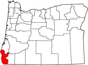 |
| Deschutes County | 017 | Bend | 1916 | Southern part of Crook County | "Riviere des Chutes", French for "River of the Falls". | 176,635 | 3,018 sq mi (7,817 km2) | 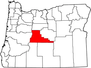 |
| Douglas County | 019 | Roseburg | 1852 | Portion of Umpqua County which lay east of the Coast Range summit | Stephen A. Douglas (1813–1861), a U.S. Senator who supported Oregon statehood | 110,395 | 5,037 sq mi (13,046 km2) | 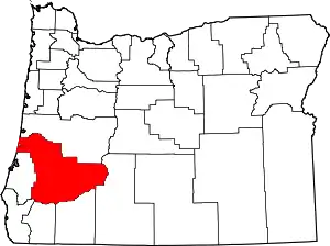 |
| Gilliam County | 021 | Condon | 1885 | Eastern third of Wasco County | Cornelius Gilliam (1798–1848), a pioneer who commanded the forces of the Provisional Government of Oregon after the Whitman massacre | 1,980 | 1,204 sq mi (3,118 km2) | 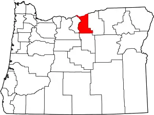 |
| Grant County | 023 | Canyon City | 1864 | Parts of old Wasco and old Umatilla counties | Ulysses S. Grant (1822–1885), army officer who served in the Oregon Territory; a Union general in the American Civil War at the time of the county's creation; and subsequently President of the United States (1869–1877) | 7,410 | 4,529 sq mi (11,730 km2) | 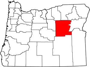 |
| Harney County | 025 | Burns | 1889 | Southern two-thirds of Grant County | William S. Harney (1800–1889), a cavalry officer of the period, who was involved in the Pig War | 7,320 | 10,135 sq mi (26,250 km2) | 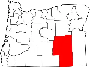 |
| Hood River County | 027 | Hood River | 1908 | Northwest portion of Wasco County | The Hood River (a tributary of the Columbia River), which flows through the county | 24,735 | 522 sq mi (1,352 km2) | 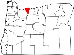 |
| Jackson County | 029 | Medford | 1852 | Southwestern portion of Lane County and the unorganized area south of Douglas and Umpqua Counties | Andrew Jackson (1767–1845), the seventh President of the United States | 213,765 | 2,785 sq mi (7,213 km2) | 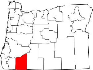 |
| Jefferson County | 031 | Madras | 1914 | Crook County | Mount Jefferson, which is located on its western boundary, named in turn for Thomas Jefferson (1743–1826), the 3rd president of the United States. | 22,790 | 1,781 sq mi (4,613 km2) | 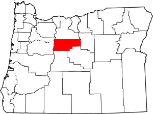 |
| Josephine County | 033 | Grants Pass | 1856 | Western half of Jackson County | Virginia "Josephine" Rollins, the first white woman to make this county her home. | 84,675 | 1,640 sq mi (4,248 km2) | 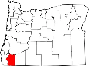 |
| Klamath County | 035 | Klamath Falls | 1882 | Western part of Lake County | The Klamath or Clamitte tribe, which has had a presence in the area for 10,000 years. | 67,410 | 5,945 sq mi (15,397 km2) | 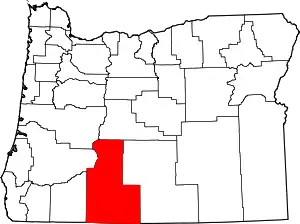 |
| Lake County | 037 | Lakeview | 1874 | Jackson and Wasco Counties | Numerous lakes and hot springs. | 8,015 | 7,940 sq mi (20,565 km2) | 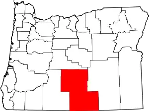 |
| Lane County | 039 | Eugene | 1851 | Southern part of Linn County and the portion of Benton County east of Umpqua County | Gen. Joseph Lane (1801–1881), the first governor of Oregon Territory | 365,940 | 4,554 sq mi (11,795 km2) | 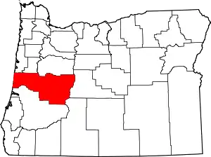 |
| Lincoln County | 041 | Newport | 1893 | Western portion of Benton County and Polk County | Abraham Lincoln (1809–1865), sixteenth President of the United States. | 47,735 | 980 sq mi (2,538 km2) |  |
| Linn County | 043 | Albany | 1847 | Southern portion of Champoeg (later Marion) County | U.S. Senator Lewis F. Linn (1795–1843) of Missouri, author of the Donation Land Act, which provided free land to settlers in the West. | 122,315 | 2,291 sq mi (5,934 km2) | 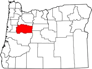 |
| Malheur County | 045 | Vale | 1887 | Southern portion of Baker County | Malheur River (formally "Riviere au Malheur" or "Unfortunate River"), named by French trappers whose property and furs were stolen from their river encampment. | 31,705 | 9,888 sq mi (25,610 km2) | 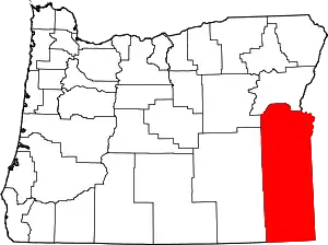 |
| Marion County | 047 | Salem | 1843 | One of the original four districts of the Oregon territory | Francis Marion (1732–1795), American Revolutionary War general | 333,950 | 1,185 sq mi (3,069 km2) | 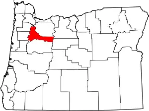 |
| Morrow County | 049 | Heppner | 1885 | Western portion of Umatilla County and a small portion of eastern Wasco County | Jackson L. Morrow, a state representative who advocated for the formation of the county. | 11,745 | 2,033 sq mi (5,265 km2) | 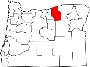 |
| Multnomah County | 051 | Portland | 1854 | Eastern part of Washington and the northern part of Clackamas counties | The Indian village of Multnomah, on Sauvie Island. The word is derived from nematlnomaq, probably meaning downriver. Lewis and Clark made note of the name in 1805, and applied that name to all local Indians. | 790,670 | 435 sq mi (1,127 km2) | 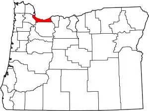 |
| Polk County | 053 | Dallas | 1845 | Yamhill District | James Knox Polk (1795–1849), President of the United States at the time of the county's creation | 79,730 | 741 sq mi (1,919 km2) |  |
| Sherman County | 055 | Moro | 1889 | Northeast corner of Wasco County | William Tecumseh Sherman (1820–1891), American Civil War general, and businessman, educator, and author | 1,795 | 823 sq mi (2,132 km2) | 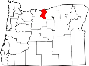 |
| Tillamook County | 057 | Tillamook | 1853 | Clatsop, Yamhill and Polk Counties | Tillamook (or Killamook) Native American people. | 25,920 | 1,102 sq mi (2,854 km2) | 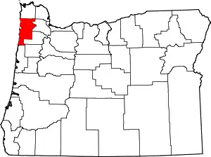 |
| Umatilla County | 059 | Pendleton | 1862 | Central portion of Wasco County | Sahaptin word, possibly meaning laughing waters. | 79,880 | 3,215 sq mi (8,327 km2) | 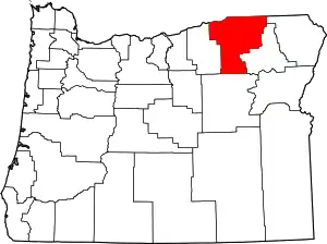 |
| Union County | 061 | La Grande | 1864 | Baker County | The town of Union, which had been established two years before and named by its founders for the "Union" of the states during the Civil War. | 26,745 | 2,037 sq mi (5,276 km2) | 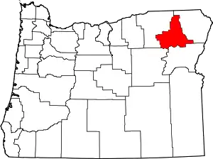 |
| Wallowa County | 063 | Enterprise | 1887 | Eastern portion of Union County. | The Nez Perce word wallowa to designate a tripod of poles used to support fish nets. The area was claimed by the Chief Joseph band of the Nez Perce as its hunting and fishing grounds | 7,140 | 3,145 sq mi (8,146 km2) | 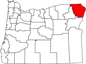 |
| Wasco County | 065 | The Dalles | 1854 | Parts of Clackamas, Lane, Linn and Marion counties | The Wasco (or Wascopam) Native American tribe. | 26,700 | 2,381 sq mi (6,167 km2) | 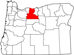 |
| Washington County | 067 | Hillsboro | 1843 | One of the original four districts of the Oregon Country (as Twality District) | George Washington (1732–1799), Founding Father of the United States and first President of the United States | 583,595 | 724 sq mi (1,875 km2) | 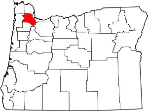 |
| Wheeler County | 069 | Fossil | 1899 | Grant County, Gilliam County, and Crook County | Henry H. Wheeler, who operated the first mail stage line from The Dalles to Canyon City. | 1,465 | 1,715 sq mi (4,442 km2) | 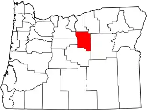 |
| Yamhill County | 071 | McMinnville | 1843 | One of the original four districts of the Oregon Country | The Yamhelas, members of the Kalapuya Native American family, who lived along the Yamhill River in the western Willamette Valley. | 104,990 | 716 sq mi (1,854 km2) | 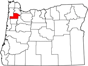 |
See also
References
- "U.S. Census Bureau QuickFacts: Multnomah County, Oregon". census.gov.
- "Oregon Secretary of State: Constitution of Oregon". sos.oregon.gov.
- "EPA County FIPS Code Listing". EPA. Retrieved April 9, 2007.
- National Association of Counties. "NACo – Find a county". Archived from the original on October 25, 2007. Retrieved April 26, 2007.
- Oregon State Archives. "County Government". Oregon Blue Book. Retrieved February 23, 2008.
- "Certified Population Estimates for Oregon and Counties (2016)". Population Research Center. Portland State University. December 15, 2016. Retrieved March 1, 2017.
External links
| Wikimedia Commons has media related to Counties of Oregon. |
- Historic county boundaries from the Oregon Archives
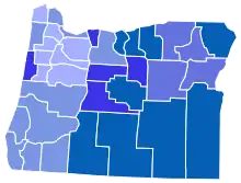
- Map of counties adjusted for population

This article is issued from Wikipedia. The text is licensed under Creative Commons - Attribution - Sharealike. Additional terms may apply for the media files.