Beaver Harbour, New Brunswick
Beaver Harbour is a community on the Fundy shore of New Brunswick, Canada.
Beaver Harbour | |
|---|---|
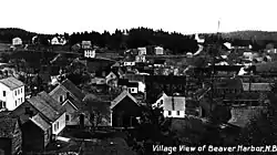 Beaver Harbour in 1920 | |
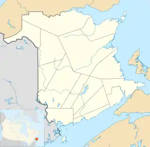 Beaver Harbour Location within New Brunswick. | |
| Coordinates: 45°04′23″N 66°44′34″W | |
| Country | |
| Province | |
| County | Charlotte |
| Electoral Districts Federal | New Brunswick Southwest |
| Provincial | Charlotte-The Isles |
| Time zone | UTC-4 (AST) |
| • Summer (DST) | UTC-3 (ADT) |
| Postal code(s) | E5H |
| Area code(s) | 506 |
| Highways | |
Most of the community forms the Local service district of Beaver Harbour, which was established in 1971.[1] It is also a census subdivision of Census Canada. Since the formation of the LSD, the community has expanded past the original boundaries into the LSD of the parish of Pennfield.
In 1866 it had about 30 resident families, and grew to a population of 150 by 1871, the 500 in 1898.[2] As of 2016, the population was 277.[3]
It is the site of the Lighthouse Point Light, originally built in 1875 and subsequently rebuilt. It is a fiberglass tapered cylindrical tower with balcony and lantern.[4]
References
- "Regulation 71-17 under the Municipalities Act (O. C. 71-127)". The Royal Gazette. Fredericton, NB, Canada. 129: 154. 3 March 1971. Filed February 17, 1971.
- "Beaver Harbour". Provincial Archives of New Brunswick. Retrieved 22 June 2020.
- "Beaver Harbour, Local service district [Designated place], New Brunswick and New Brunswick [Province]". Satistics Canada. Retrieved 22 June 2020.
- "Lighthouse Point Lighthouse". LighthouseFriends. Retrieved 22 June 2020.
Places adjacent to Beaver Harbour, New Brunswick | ||||||||||
|---|---|---|---|---|---|---|---|---|---|---|
| ||||||||||
| Subdivisions | |
|---|---|
| Cities | |
| |
This article is issued from Wikipedia. The text is licensed under Creative Commons - Attribution - Sharealike. Additional terms may apply for the media files.