Bedihošť
Bedihošť Czech pronunciation: [ˈbɛɟɪɦoʃc] is a municipality and village in Prostějov District in the Olomouc Region of the Czech Republic. It has about 1,100 inhabitants.
Bedihošť | |
|---|---|
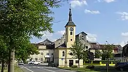 Chapel of Saint Florian | |
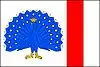 Flag  Coat of arms | |
 Bedihošť Location in the Czech Republic | |
| Coordinates: 49°26′54″N 17°9′59″E | |
| Country | |
| Region | Olomouc |
| District | Prostějov |
| First mentioned | 1275 |
| Area | |
| • Total | 6.46 km2 (2.49 sq mi) |
| Elevation | 209 m (686 ft) |
| Population (2020-01-01[1]) | |
| • Total | 1,068 |
| • Density | 170/km2 (430/sq mi) |
| Time zone | UTC+1 (CET) |
| • Summer (DST) | UTC+2 (CEST) |
| Postal code | 798 21 |
| Website | www |
Bedihošť lies approximately 5 kilometres (3 mi) south-east of Prostějov, 18 km (11 mi) south of Olomouc, and 210 km (130 mi) east of Prague.
History
Its first historical reference is from the year 1275.
Sights
Main sights are the Chapel of Saint Wenceslaus, the Chapel of Saint Florian and the sundial.
References
- "Population of Municipalities – 1 January 2020". Czech Statistical Office. 2020-04-30.
External links
| Wikimedia Commons has media related to Bedihošť. |
- Official website (cz)
| Authority control |
|
|---|
This article is issued from Wikipedia. The text is licensed under Creative Commons - Attribution - Sharealike. Additional terms may apply for the media files.