Behror
Behror (IPA: [bɛɦɾoːɽ] (![]() listen)) is a municipal town in the Alwar district of Rajasthan. It serves as the administrative headquarters of eponymous Behror Tehsil. Situated 120 km south-west of national capital New Delhi and being a part of National Capital Region, it also comes under National Capital Region Planning Board which is a federal authority for urban planning purposes in NCR.[3] It is clubbed under Shahjahanpur-Neemrana-Behror (SNB) Complex in NCR-which includes 137 revenue villages . In this cluster Behror municipality is the largest urban conglomeration.[4] This region is also known as 'Ahirwal region' and serves as an industrial hub for the state of Rajasthan. Behror municipality spread out in an area of 15 km2 is divided into four revenue villages namely Behror tarf Gangabishan, Behror tarf Doongrasi, Behror tarf Nainsukh, Behror tarf Balram.[5]
listen)) is a municipal town in the Alwar district of Rajasthan. It serves as the administrative headquarters of eponymous Behror Tehsil. Situated 120 km south-west of national capital New Delhi and being a part of National Capital Region, it also comes under National Capital Region Planning Board which is a federal authority for urban planning purposes in NCR.[3] It is clubbed under Shahjahanpur-Neemrana-Behror (SNB) Complex in NCR-which includes 137 revenue villages . In this cluster Behror municipality is the largest urban conglomeration.[4] This region is also known as 'Ahirwal region' and serves as an industrial hub for the state of Rajasthan. Behror municipality spread out in an area of 15 km2 is divided into four revenue villages namely Behror tarf Gangabishan, Behror tarf Doongrasi, Behror tarf Nainsukh, Behror tarf Balram.[5]
Behror | |
|---|---|
Municipal Town / Semi-urban Area | |
  Left to right: NH48 Highway Flyover at Behror (L), Old Busstop Circle on Shahid Marg Behror (R) | |
| Nickname(s): Raath[1] | |
 Behror Behror in Rajasthan  Behror Behror (India) | |
| Coordinates: 27.88°N 76.28°E | |
| Country | |
| State | Rajasthan |
| District | Alwar |
| Government | |
| • Type | Municipal Corporation |
| • Body | Nagar Palika Behror |
| Elevation | 312 m (1,024 ft) |
| Population (2011) | |
| • Total | 29,531 |
| Language | |
| • Official | Hindi[2] |
| • Regional | Mewati |
| Time zone | UTC+5:30 (IST) |
| PIN | 301701 |
| Telephone code | (+91)-1494 |
| Vehicle registration | RJ02 |
| Nearest railway station | Narnaul (25 km away) |
| Nearest airport | Indra Gandhi Intnl. Airport (115 km away) |
| Vidhan Sabha Constituency | Behror |
| M.L.A. | Baljeet Yadav |
History
Several late harappan period pottery and archaeological artefacts have been found around Sahibi River Basin.[6][7]
In the sixth century AD, King Shaliwahan of Bhati clan ruled northern part of the current Alwar region near Sahibi River and established two cities. One was Kot whose remains are found in Singhali village of Mundawar tehsil and the second one Shaliwahpur where the current Behror city is situated.[8]
Before Independence Behror was a Tehsil and urban center under Alwar Princely state. During the reign of Rao Pratap Singh (Ruler of Alwar), Behror and surrounding Bansur area were incorporated in Alwar Princely state.
In freedom movement Pran Sukh Yadav, who fought along with Rao Tula Ram against the British in 1857 Freedom Struggle at the battle of Naseebpur near Behror in Narnaul, hailed from Behror Tehsil and was important in raising local population of Aheers against British.[9][10]
Behror has remained important center of attraction in Ahirwal region and as a part of the larger Matsya region due to proximity to Delhi.[11]
Geography
Located at co-ordinates 27.88°N 76.28°E.[12] with an average elevation of 312 metres (1,024 ft) Behror sits amidst generally plain and very fertile agricultural land with Aravali Range mountains running north–south approximately 5 km to west of Behror.
According to CGWA, it has been identified as an area for regulating withdrawal of ground water (Dark Zone) since there are limited surface water resources and mostly ground water is used as main source of water.[13] Sahibi River, which is an ephemeral river flows 10 km south-east of Behror, flowing south-west to north-east. Usually these days it is dry. Sota river is 7 km to south- west[14] of Behror and drains in Sahibi river.[15]
The climate is mostly dry, and mainly summer, winter and a short rainy season are the main seasons, winter starts from November and till March, summer remains till July.[16] January is the coldest month when it may get as cold as 2 °C. Around four-fifths of the average rainfall is received in July, August and September.[17]
The soil is highly fertile and agriculture is one of the main occupation in the region. Mattiyar, a type of loamy soil, is most commonly found in Behror, Chiknot type of soil commonly found in Alwar district is characteristically not found in Behror and Tijara Tehsils.[18]
The city falls under Seismic Activity Zones 4 with some area of Tahsil under Zone 3 and another under Zone 4.
Forests are mainly of deciduous hilly type found along tracts of Aravalli hills with dominant trees being kikar, neem and dhak.[19] Main mineral found is quartz. There has been rapid changes in the environment surrounding city due to rapid urbanisation and increased pollution.[20]
Administration
Behror Semi-Urban area comprises Behror Municipality and surrounding rural areas.
Behror City is Class 3 municipal town according to Rajasthan Government classification system and is proposed to become a Regional Centre city.[21]
Eponymous Behror Tehsil is an administrative unit comprising Behror city and surrounding gram panchayats/villages. Behror Legislative constituency is the political constituency including Behror city and surrounding villages for election of representative to State legislature.[22]
Behror municipality
The Behror municipality – which is Behror city proper – is divided into 25 wards for which elections are held every five years.
Behror Legislative Constituency
Behror Legislative Constituency is categorised as rural seat in Legislative constituency classification. There are a total of 211,534 voters in the seat, which includes 110,515 male voters, and 101,019 female voters. In the 2018 Rajasthan elections, Behror recorded a voter turnout of 74.69%. In 2013 the turnout was 76%, and in 2008 it was 69%.[23]
Behror Tehsil
Behror Tehsil comprises 62 Gram panchayats and 64 Patwar circles with ILR Code - 5.
Economy
Due to rapid development waste disposal has become a problem in the municipality and wider region with no proper waste disposal sites.[24]
Transportation
Behror municipality is well connected to major Urban conglomerations in the area.[25]
Roadways
The most important connecting road is NH-8 (NH - 48) which passes through the city connects it to Delhi to the North-East and Jaipur to the South-West. This important link is a part of the Golden Quadrilateral project of NHAI. Recently NH-8 had undergone a major development and now it has a six-lane road from Jaipur to Delhi for better.[13] RTDC run Hotel Midway was situated on NH-8 in Behror before it was closed down.[26]
Behror is midway between Jaipur and Delhi, at a distance of 130 km from the State Capital and 120 km from the National Capital.
Behror has also direct connectivity to the District capital, Alwar which is 60 km apart. Behror Tehsil borders Haryana's Mahendragarh/Narnaul district and is connected to Narnaul City by State Highway - 14[24] which reaches up to district headquarters Alwar.
MDR (Major Dsitrict Road ) - 78 road connects Behror municipality to Rewari and ICD at Kund.[27]
Railways
Nearest Railway station is Narnaul railway station 25 km away on Phulera-Rewari-Delhi Railway Line .[28] Inland Container Depot is being developed near Kund Railway station of Behror Tehsil under DMRC project.[4]
Landmarks and monuments
Forts

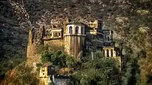
Neemrana Fort Complex located 10 km away is the most important Landmark. The famous Neemrana fort was built in the 16th century and was occupied by Chouhan Rajputs till 1947 .[31]
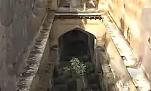
Taseeng Fort located in Aravali hills 5 km away is another place of attraction but now in poor condition due to neglect. It was last occupied by Badgurjar Clan. Before them Chouhans from Machedi were its inhabitants.[32]
Demographics
According to 2011 Indian Census, Behror Municipality had population of 29,531 of which 15,570 were males and 13,961 were females. Children between the age of 0 to 6 years were 3770 which is 12.77% of total population. Female sex ratio was of 897. The total number of literates Behror was 21,656, which constituted 73.33% of the total population with male literacy of 80.04% and female literacy of 65.85%. The effective literacy rate of 7+ population of Behror was 84.1%, of which male literacy rate was 92.4% and female literacy rate was 75.1%. The Scheduled Castes and Scheduled Tribes have a population of 4,466 and 940 respectively. Behror municipality has total administration over 5,484 houses.[36]
| Decade | Population | Growth rate ( in % ) |
|---|---|---|
| 1971 | 6,868 | - |
| 1981 | 9,653 | 40.05 |
| 1991 | 16,238 | 68.21 |
| 2001 | 22,856 | 40.76 |
| 2011 | 29,531 | 29.20 |
Languages
Hindi being the official language of state of Rajasthan is the official language of the city. But in this border area most common vernacular language - Raathi/Ahirwati - has influences of administrative Hindi, Haryanvi / Bangru, Mewati .[37] It is influenced by Bangru the most, and seems rough to people not used to it.[38]
Culture and festivals
The Rath cattle fair is organised in the month of May for the improvement of the Rath breed in Alwar district.[33]
See also
References
- "अलवर की भौगोलिक एवं इतिहासिक पृष्ठभूमि" [Alwar Ki Bhogolik evam Ithesik Prishtbhoomi] (PDF). Shodhganga (in Hindi). Shodhganga INFLIBNET. p. 3. Retrieved 11 July 2020.
- "52nd Report of the Commissioner for Linguistic Minorities in India" (PDF). nclm.nic.in. Ministry of Minority Affairs. Archived from the original (PDF) on 25 May 2017. Retrieved 27 September 2019.
- "Archived copy" (PDF). Archived from the original (PDF) on 17 July 2011. Retrieved 27 March 2010.CS1 maint: archived copy as title (link)
- "SNB Master Plan" (PDF). Master Plan Report. Govt. Of Rajasthan: 15.
- Planner, Chief Town. Shahjahanpur-Neemrana-Behror Complex (PDF). Jaipur: UDH, Govt. of Rajasthan. p. 13.
- "( Sahibi River Basin ) 4 Chapter 1" [This phenomenon of settlement migration towards east between the Ghaggar and Yamuna divide was thoroughly studied by Manmohan Kumar (2009: 1-27) who foundthat the Late Harappan sites were increased in number towards the river Yamuna] (PDF): 2. Retrieved 11 July 2020. Cite journal requires
|journal=(help) - A History of Ancient and Early Medieval India : From stone age to 12th century. Pearson. 2009. p. 116. ISBN 9788131716779.
- "Rajasthan - Alwar - Bhogolik, Etihasik Pristhbhumi: Sthapana". ignca.nic.in. Retrieved 10 July 2020.
- "Shodhganga" (PDF).
- Freedom Struggle of 1857 - Renu Saran. Diamond Books. ISBN 9789350830659.
- "History OF ALWAR". Retrieved 1 July 2020.
- Falling Rain Genomics, Inc - Behror
- Sub-Regional Plan for Rajasthan Sub-Region - 2021 Report. Jaipur: State Press, Govt. Of Rajasthan.
- Master Plan for Behror, 1989-2001. Chief Town Planner, Govt. Of Rajasthan.
- Rajasthan State Gazetteer: History and culture. p. 6.
- "Master Plan 2041SNB" (PDF). UDH Rajasthan. Retrieved 7 July 2020.
- The Imperial Gazetteer of India, 1908 (Volume 5 ). Oxford: Clarendon Press. 1909. p. 255.
- The Imperial Gazetteer of India, 1908. 5. Oxford: Clarendon Press. 1909. p. 261.
- Lenin, Janaki (6 July 2020). "Dhok, the purple-heart tree warrior of the Aravallis". The Hindu. ISSN 0971-751X. Retrieved 11 July 2020.
- Sub-Regional Plan for Rajasthan Sub-Region - 2021 Report (PDF). Jaipur: State Press, Govt. Of Rajasthan. pp. 153, 228, 249.
- Sub Regional Plan 2021 (PDF). Jaipur: Govt. Of Rajasthan. pp. Final Report - PAGE 35.
- "Administration". Alwar District.
- "Behror Elections 2018". News18. Retrieved 4 July 2020.
- Sub Regional Plan 2021 (PDF). Jaipur: Govt. Of Rajasthan. pp. Final Report - Page 148.
- 6 Oct, Rohit E. David | TNN |; 2018; Ist, 02:09. "Rapid rail to be linked with metro, work on Delhi-Behror track may start in March 2019 | Gurgaon News - Times of India". The Times of India. Retrieved 11 July 2020.CS1 maint: numeric names: authors list (link)
- "RTDC Midway in Bad Condition". Patrika. Retrieved 4 July 2020.
- Sub Regional Plan (PDF). Jaipur: Govt. Of Rajasthan. pp. Annex 6.3 - Page 6.
- Sub-Regional Plan 2021 (PDF). Jaipur: Govt. Of Rajasthan. pp. Executive Summary - Page 1.
- "Airport Near Behror, Rajasthan, India, Nearest Airports". airport.globefeed.com. Retrieved 11 July 2020.
- "राजस्थान में यहां हवाई अड्डे की फिर चर्चा, सरकार ने एयरपोर्ट की ओर बढ़ाया कदम, मुख्यमंत्री ने की थी यह घोषणा". Patrika News (in Hindi). Retrieved 11 July 2020.
- "Alwar Tourist Places". Alwar District. Retrieved 1 July 2020.
- "विरासत के झरोखे से: कभी अभेद्य रहा, पर अब तिल-तिल कर मर रहा हूं". Patrika News (in Hindi). Retrieved 10 July 2020.
- Census 2011 District Handbook - Alwar (PDF). Jaipur: Directorate of Census Operatioins. 2014. pp. 30, 31.
- "Mansa Devi Bell from 1437 still Ringing". Dainik Bhaskar. Retrieved 4 July 2020.
- "सिसोदिया वंशजों ने बनाया जिलाणी माता मंदिर". Dainik Bhaskar (in Hindi). 9 December 2017. Retrieved 10 July 2020.
- "Census of India: Behror (M)". www.censusindia.gov.in. Retrieved 27 September 2019.
- "Mewati". Ethnologue. Retrieved 14 September 2019.
- "Alwar Ki Bhogolik evam Ithehasik Prishthbhoomi" (PDF). Sodhganga. Adhyaya 1: 9. 11 July 2020 – via Sodhganga/INFLIBNET.
