Belvidere, Kansas
Belvidere is an unincorporated community in Kiowa County, Kansas, United States, and located along the Medicine Lodge River.
Belvidere, Kansas | |
|---|---|
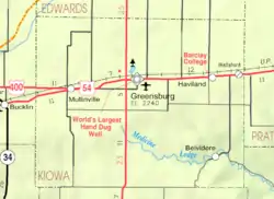 KDOT map of Kiowa County (legend) | |
 Belvidere  Belvidere | |
| Coordinates: 37°27′1″N 99°4′48″W | |
| Country | United States |
| State | Kansas |
| County | Kiowa |
| Founded | 1880s |
| Elevation | 1,837 ft (560 m) |
| Time zone | UTC-6 (CST) |
| • Summer (DST) | UTC-5 (CDT) |
| Area code | 620 |
| FIPS code | 20-05875 |
| GNIS ID | 470715 |
History
Belvidere was a shipping point on the Atchison, Topeka and Santa Fe Railway.[1]
A post office named Glick operated from 1883 until 1890. The Glick post office was renamed Belvidere on April 26, 1890, remained in operation until it was discontinued on November 23, 1996.[2]
Nearby are the Roth Petroglyph Site and the Star Petroglyph Site. Both are on the National Register of Historic Places.
In the mid-2000s, Belvidere become the home of a NOAA Weather Radio transmitter, WNG534, operated by the National Weather Service Forecast Office in nearby Dodge City.
References
- Blackmar, Frank Wilson (1912). Kansas: A Cyclopedia of State History, Embracing Events, Institutions, Industries, Counties, Cities, Towns, Prominent Persons, Etc. Standard Publishing Company. pp. 172.
- "Kansas Post Offices, 1828-1961 (archived)". Kansas Historical Society. Archived from the original on October 9, 2013. Retrieved 12 June 2014.
Further reading
External links
Municipalities and communities of Kiowa County, Kansas, United States | ||
|---|---|---|
| Cities |  Map of Kansas highlighting Kiowa County | |
| Unincorporated communities | ||
| Township | ||
| ||
This article is issued from Wikipedia. The text is licensed under Creative Commons - Attribution - Sharealike. Additional terms may apply for the media files.