Mullinville, Kansas
Mullinville is a city in Kiowa County, Kansas, United States. As of the 2010 census, the city population was 255.[6]
Mullinville, Kansas | |
|---|---|
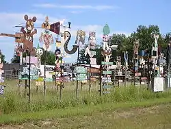 M. T. Liggett's sculptures (2007) | |
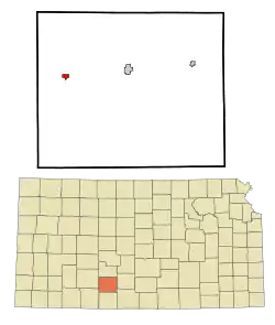 Location within Kiowa County and Kansas | |
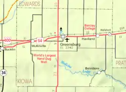 KDOT map of Kiowa County (legend) | |
| Coordinates: 37°35′12″N 99°28′35″W | |
| Country | United States |
| State | Kansas |
| County | Kiowa |
| Founded | 1880s |
| Platted | 1886 |
| Incorporated | 1911 |
| Named for | Alfred Mullin |
| Area | |
| • Total | 0.64 sq mi (1.66 km2) |
| • Land | 0.64 sq mi (1.66 km2) |
| • Water | 0.00 sq mi (0.00 km2) |
| Elevation | 2,323 ft (708 m) |
| Population | |
| • Total | 255 |
| • Estimate (2019)[3] | 241 |
| • Density | 375.98/sq mi (145.06/km2) |
| Time zone | UTC-6 (CST) |
| • Summer (DST) | UTC-5 (CDT) |
| ZIP code | 67109 |
| Area code | 620 |
| FIPS code | 20-49075 [4] |
| GNIS ID | 0474252 [5] |
History
The first post office at Mullinville was established in September 1884.[7]
Mullinville was laid out in about 1886.[8] It was named for Alfred A. Mullin, a pioneer settler and storekeeper.[9]
Geography
Mullinville is located at 37°35′12″N 99°28′35″W (37.586706, -99.476387).[10] According to the United States Census Bureau, the city has a total area of 0.60 square miles (1.55 km2), all of it land.[11]
Demographics
| Historical population | |||
|---|---|---|---|
| Census | Pop. | %± | |
| 1890 | 79 | — | |
| 1910 | 289 | — | |
| 1920 | 361 | 24.9% | |
| 1930 | 436 | 20.8% | |
| 1940 | 428 | −1.8% | |
| 1950 | 410 | −4.2% | |
| 1960 | 385 | −6.1% | |
| 1970 | 376 | −2.3% | |
| 1980 | 339 | −9.8% | |
| 1990 | 289 | −14.7% | |
| 2000 | 279 | −3.5% | |
| 2010 | 255 | −8.6% | |
| 2019 (est.) | 241 | [3] | −5.5% |
| U.S. Decennial Census | |||
2010 census
As of the census[2] of 2010, there were 255 people, 107 households, and 68 families residing in the city. The population density was 425.0 inhabitants per square mile (164.1/km2). There were 132 housing units at an average density of 220.0 per square mile (84.9/km2). The racial makeup of the city was 94.9% White, 0.8% African American, 0.4% Native American, 0.8% Asian, 1.6% from other races, and 1.6% from two or more races. Hispanic or Latino of any race were 8.2% of the population.
There were 107 households, of which 27.1% had children under the age of 18 living with them, 52.3% were married couples living together, 7.5% had a female householder with no husband present, 3.7% had a male householder with no wife present, and 36.4% were non-families. 32.7% of all households were made up of individuals, and 19.6% had someone living alone who was 65 years of age or older. The average household size was 2.38 and the average family size was 2.99.
The median age in the city was 41.3 years. 26.3% of residents were under the age of 18; 5.4% were between the ages of 18 and 24; 23.6% were from 25 to 44; 21.6% were from 45 to 64; and 23.1% were 65 years of age or older. The gender makeup of the city was 49.4% male and 50.6% female.
2000 census
As of the census[4] of 2000, there were 279 people, 113 households, and 80 families residing in the city. The population density was 465.8 people per square mile (179.5/km2). There were 132 housing units at an average density of 220.4 per square mile (84.9/km2). The racial makeup of the city was 97.85% White, 1.43% Asian, and 0.72% from two or more races. Hispanic or Latino of any race were 1.43% of the population.
There were 113 households, out of which 31.0% had children under the age of 18 living with them, 63.7% were married couples living together, 5.3% had a female householder with no husband present, and 29.2% were non-families. 29.2% of all households were made up of individuals, and 18.6% had someone living alone who was 65 years of age or older. The average household size was 2.47 and the average family size was 3.04.
In the city, the population was spread out, with 28.3% under the age of 18, 3.9% from 18 to 24, 22.9% from 25 to 44, 21.1% from 45 to 64, and 23.7% who were 65 years of age or older. The median age was 41 years. For every 100 females, there were 93.8 males. For every 100 females age 18 and over, there were 96.1 males.
The median income for a household in the city was $36,875, and the median income for a family was $39,375. Males had a median income of $32,500 versus $21,667 for females. The per capita income for the city was $18,258. About 10.5% of families and 9.2% of the population were below the poverty line, including 11.6% of those under the age of eighteen and 13.0% of those 65 or over.
Education
The community is served by Kiowa County USD 422 public school district. Mullinville is home to 21st Century Learning Academy, an accredited virtual school of USD 422.[12] In 2011, USD 422 absorbed the former Mullinville USD 424, which had dissolved.[13]
The Mullinville High School mascot was Tigers.[14] The Mullinville Tigers won the following Kansas State High School championships:
Media
Mullinville is mentioned in the song "(We're Not) The Jet Set" by George Jones and Tammy Wynette.[17] The line goes, "And you won't find [Aristotle] Onassis in Mullinville, Kansas". Mullinville is one action setting for "Hard-Luck Henry", a 1967 episode of the long-running TV series, "Gunsmoke".
Notable people
- M.T. Liggett (1930-2017), American Folk Sculptor, was born in Mullinville.[18]
Gallery
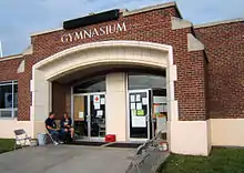 Gym shelter on May 5, 2007, the day after an F5 tornado devastated neighboring Greensburg
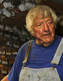 M.T. Liggett as he appears in his workshop in Mullinville (2013)
References
- "2019 U.S. Gazetteer Files". United States Census Bureau. Retrieved July 24, 2020.
- "U.S. Census website". United States Census Bureau. Retrieved 2012-07-06.
- "Population and Housing Unit Estimates". United States Census Bureau. May 24, 2020. Retrieved May 27, 2020.
- "U.S. Census website". United States Census Bureau. Retrieved 2008-01-31.
- "US Board on Geographic Names". United States Geological Survey. 2007-10-25. Retrieved 2008-01-31.
- "2010 City Population and Housing Occupancy Status". U.S. Census Bureau. Retrieved March 6, 2011.
- "Kansas Post Offices, 1828-1961 (archived)". Kansas Historical Society. Archived from the original on October 9, 2013. Retrieved 12 June 2014.CS1 maint: unfit URL (link)
- Kansas State Historical Society (1916). Biennial Report of the Board of Directors of the Kansas State Historical Society. Kansas State Printing Plant. pp. 217.
- "Profile for Mullinville, Kansas". ePodunk. Archived from the original on 14 May 2019. Retrieved 12 June 2014.
- "US Gazetteer files: 2010, 2000, and 1990". United States Census Bureau. 2011-02-12. Retrieved 2011-04-23.
- "US Gazetteer files 2010". United States Census Bureau. Archived from the original on 2012-01-25. Retrieved 2012-07-06.
- "21st Century Learning Academy". 21st Century. Retrieved 6 January 2017.
- "School consolidations in Kansas for past decade". The Topeka Capital-Journal. 2011-07-24. Retrieved 2020-04-26.
- "Mullinville High School". classmates. Retrieved 10 January 2017.
- "Track & Field". KSHSAA. Retrieved 6 January 2017.
- "Basketball". KSHSAA. Retrieved 3 January 2017.
- http://www.lyrics.net/lyric/5781872
- 'Kansas roadside artist M.T. Liggett dies at 87,' The Wichita Eagle, Beccy Tanner, August 17, 2017
Further reading
External links
| Wikimedia Commons has media related to Mullinville, Kansas. |
- City
- Historical
- M.T. Liggett - An Artist With a 'Bite' on YouTube, from Hatteberg's People on KAKE TV news
- Maps
- Mullinville City Map, KDOT
Municipalities and communities of Kiowa County, Kansas, United States | ||
|---|---|---|
| Cities | 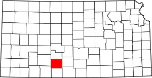 Map of Kansas highlighting Kiowa County | |
| Unincorporated communities | ||
| Township | ||
| ||