Benton, Tennessee
Benton is a town in Polk County, Tennessee, United States. The population was 1,385 at the 2010 census.[6] It is the county seat of Polk County.[7]
Benton, Tennessee | |
|---|---|
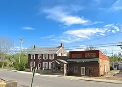 The Drug Store (left) and Polk County News block in Benton | |
 Location of Benton in Polk County, Tennessee. | |
| Coordinates: 35°10′27″N 84°39′13″W[1] | |
| Country | United States |
| State | Tennessee |
| County | Polk |
| Founded | 1840 |
| Incorporated | 1915[2] |
| Named for | Thomas Hart Benton |
| Area | |
| • Total | 3.03 sq mi (7.85 km2) |
| • Land | 3.03 sq mi (7.85 km2) |
| • Water | 0.00 sq mi (0.00 km2) |
| Elevation | 741 ft (226 m) |
| Population (2010) | |
| • Total | 1,385 |
| • Estimate (2019)[4] | 1,278 |
| • Density | 421.36/sq mi (162.71/km2) |
| Time zone | UTC-5 (Eastern (EST)) |
| • Summer (DST) | UTC-4 (EDT) |
| ZIP code | 37307 |
| Area code(s) | 423 |
| FIPS code | 47-05040[5] |
| GNIS feature ID | 1327567[1] |
Benton is included in the Cleveland Metropolitan Statistical Area. Nancy Ward, a Cherokee known as Nanyehi, was a Beloved Woman, a leader among her people. For many years, she participated in negotiations with the British and Americans. After the American Revolution, she had an inn here and was finally buried here. The Nancy Ward Chapter of the DAR, named in her honor, has marked the graves of her and her son Fivekiller.
History
Benton was founded in 1840 as a county seat for Polk County, which had been established the previous year. The town, originally a trading post known as McKamy's stock stand, was named in honor of politician and US Senator from Missouri, Thomas Hart Benton.[8]
On May 27, 1983 the Benton fireworks disaster occurred on a farm southeast of the city. An explosion at a secret fireworks operation killed eleven, injured one, and caused damage within a radius of several miles, revealing the illegal business.[9] This was by far the largest and most successful known illegal fireworks operation. The blast was heard more than 20 miles away.
Geography
Benton is located at 35°10′27″N 84°39′13″W (35.1742411, -84.6535468).[1] The town is situated just southeast of the confluence of the Ocoee River and the Hiwassee River, roughly 34 miles (55 km) upstream from the latter's mouth along the Chickamauga Lake impoundment of the Tennessee River. The Unicoi Mountains rise prominently to the east of Benton.
Benton is centered on the junction of U.S. Route 411, which connects the town to Etowah to the north and Tennga, Georgia to the south, and Tennessee State Route 314, which connects Benton to Parksville, Cherokee National Forest, and the Ocoee Dam area to the southeast. Benton is located approximately 20 miles (32 km) east of Interstate 75.
According to the United States Census Bureau, the town has a total area of 2.3 square miles (6.0 km2), all land.
One of the scenic areas around Benton is Lake McCamy, where a hiking trail leads to the Benton Falls.[10][11][12]
Demographics
| Historical population | |||
|---|---|---|---|
| Census | Pop. | %± | |
| 1870 | 250 | — | |
| 1880 | 183 | −26.8% | |
| 1890 | 165 | −9.8% | |
| 1960 | 638 | — | |
| 1970 | 749 | 17.4% | |
| 1980 | 1,115 | 48.9% | |
| 1990 | 992 | −11.0% | |
| 2000 | 1,138 | 14.7% | |
| 2010 | 1,385 | 21.7% | |
| 2019 (est.) | 1,278 | [4] | −7.7% |
| Sources:[13][14] | |||
As of the census[5] of 2000, there were 1,138 people, 468 households, and 301 families residing in the town. The population density was 502.1 people per square mile (193.6/km2). There were 513 housing units at an average density of 226.3 per square mile (87.3/km2). The racial makeup of the town was 98.86% White, 0.09% African American, 0.18% Native American, 0.09% Pacific Islander, 0.09% from other races, and 0.70% from two or more races. Hispanic or Latino of any race were 0.53% of the population.
There were 468 households, out of which 26.5% had children under the age of 18 living with them, 47.6% were married couples living together, 12.8% had a female householder with no husband present, and 35.5% were non-families. 31.8% of all households were made up of individuals, and 14.5% had someone living alone who was 65 years of age or older. The average household size was 2.34 and the average family size was 2.95.
In the town, the population was spread out, with 22.7% under the age of 18, 11.1% from 18 to 24, 29.4% from 25 to 44, 22.6% from 45 to 64, and 14.2% who were 65 years of age or older. The median age was 37 years. For every 100 females, there were 91.6 males. For every 100 females age 18 and over, there were 92.6 males.
The median income for a household in the town was $22,667, and the median income for a family was $31,146. Males had a median income of $24,667 versus $23,295 for females. The per capita income for the town was $12,580. About 15.1% of families and 20.4% of the population were below the poverty line, including 34.5% of those under age 18 and 20.9% of those age 65 or over.
References
- "Benton". Geographic Names Information System. United States Geological Survey.
- Tennessee Blue Book, 2005-2006, pp. 618-625.
- "2019 U.S. Gazetteer Files". United States Census Bureau. Retrieved July 30, 2020.
- "Population and Housing Unit Estimates". United States Census Bureau. May 24, 2020. Retrieved May 27, 2020.
- "U.S. Census website". United States Census Bureau. Retrieved 2008-01-31.
- Tennessee Department of Economic and Community Development, Certified Population of Tennessee Incorporated Municipalities and Counties Archived 2014-06-30 at the Wayback Machine, State of Tennessee official website, 14 July 2011. Retrieved: 6 December 2013.
- "Find a County". National Association of Counties. Archived from the original on 2011-05-31. Retrieved 2011-06-07.
- Marian Bailey Presswood, "Polk County." The Tennessee Encyclopedia of History and Culture, 2002. Retrieved: 31 March 2008.
- "Fireworks suspect charged with deaths". The Spokesman-Review. Spokane, Washington. May 30, 1983. Retrieved April 19, 2014 – via Google News.
- Hiking Tennessee: A Guide to the State's Greatest Hiking Adventures Kelley Roark, Stuart Carroll - 2015 1493023934 " In fact, a good portion of the Benton Falls Trail is used by mountain bikers, who start at Lake McCamy and bike through past the falls on Clemmer Trail to US 64 where it intersects with TN 30 at the bottom of the mountain. "
- Hiking Waterfalls in Tennessee: A Guide to the State's Best 1493014447 Johnny Molloy - 2015 Page 135 " Benton Falls This popular waterfall starts at a popular Chilhowee Campground, a top a mountain in the Cherokee National Forest. The wide trail first takes you by a lake, then intertwines with bike trails before descending to upper Rock ..."
- Longstreet Highroad Guide to the Tennessee Mountains -H. Lea Lawrence, Vernon Summerlin, Cathy Summerlin 1563524759- 2001 Page 227 "Benton Falls is fan shaped and tumbles from a rock ledge down the face of the rock onto another rock face."
- "Census of Population and Housing: Decennial Censuses". United States Census Bureau. Retrieved 2012-03-04.
- "Incorporated Places and Minor Civil Divisions Datasets: Subcounty Resident Population Estimates: April 1, 2010 to July 1, 2012". Population Estimates. U.S. Census Bureau. Archived from the original on 11 June 2013. Retrieved 11 December 2013.
External links
| Wikimedia Commons has media related to Benton, Tennessee. |
Municipalities and communities of Polk County, Tennessee, United States | ||
|---|---|---|
| Cities | ||
| Town | ||
| Unincorporated communities | ||
| ||
| Authority control |
|---|