List of counties in Tennessee
This is a list of the 95 counties in the State of Tennessee. A county is a local level of government smaller than a state and typically larger than a city or town, in a U.S. state or territory.
| Counties of Tennessee | |
|---|---|
.png.webp) | |
| Location | State of Tennessee |
| Number | 95 |
| Populations | Greatest: 927,644 (Shelby) Least: 5,077 (Pickett) Average: 70,695 (2017) |
| Areas | Largest: 755 sq mi (1,960 km2) (Shelby) Smallest: 114 sq mi (300 km2) (Trousdale) Average: 444 sq mi (1,150 km2) |
| Government | County government |
| Subdivisions | cities, towns, unincorporated communities, census designated place |
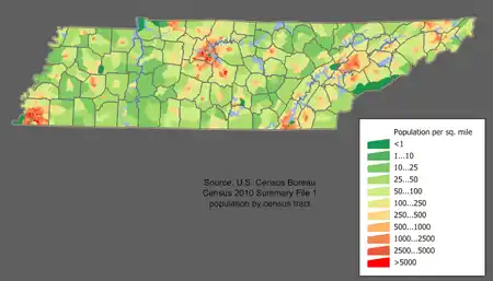
As of 2010, Shelby County was both Tennessee's most populous county, with 927,644 residents, and the largest county in area, covering an area of 755 sq mi (1,955 km2). The least populous county was Pickett County (4,945) and the smallest in area was Trousdale County, covering 114 sq mi (295 km2). As of the same year, Davidson County, in which the capital Nashville is located, covers 502 sq mi (1,300 km2) with a population of 569,891. The population of the state of Tennessee as of the 2010 census was 6,346,105 in an area of 42,169 sq mi (109,217 km2).[1][2][3] The oldest county is Washington County, founded in 1777. The most recently formed county is Chester County (1879).[1]
According to the 2000 census, the center of population for Tennessee was located at 35.795862°N 86.397772°W, 2.5 mi (4.0 km) south of Murfreesboro in Rutherford County.[4] The center of population pinpoints the location at which the population of the state, as placed on a map of the state where they reside, would balance out the map. The geographic center, the point where the map of Tennessee would balance without the population, is located 5 mi (8 km) northeast of Murfreesboro. In 1976, the Rutherford County Historical Society marked the geographic center of Tennessee with an obelisk.[5]
Some of the counties were formed in part or completely from lands previously controlled by American Indians. The "Indian lands" were territories that American Indians had occupied from pre-Columbian times and to which they were granted the legal right of occupancy in an act of the United States government. In cases where counties had been formed from that territory, the legal right of American Indian occupancy was revoked in a federal act prior to the formal establishment of the county.[6] For Tennessee, ten treaties were negotiated between 1770 and 1835, defining the areas assigned to European settlers and to American Indians, regulating the right of occupancy regarding the lands. The remaining indigenous population was eventually removed from Tennessee to what became the state of Oklahoma.[7]
The Federal Information Processing Standard (FIPS) code, which is used by the United States government to uniquely identify counties, is provided with each entry. FIPS codes are five-digit numbers; for Tennessee the codes start with 47 and are completed with the three-digit county code. The FIPS code for each county in the table links to census data for that county.[8]
Alphabetical list
| County |
FIPS code[8] | County seat[1] | Est.[1] | Origin[9] | Etymology[9] | Population | Area[10][1] | Map |
|---|---|---|---|---|---|---|---|---|
| Anderson County | 001 | Clinton | 1801 | Knox and Grainger Counties | Joseph Anderson (1757–1837), U.S. Senator from Tennessee and first Comptroller of the U.S. Treasury. | 75,129 | 338 sq mi (875 km2) | |
| Bedford County | 003 | Shelbyville | 1807 | Rutherford County | Revolutionary War officer Thomas Bedford, a large landowner in the area | 45,058 | 474 sq mi (1,228 km2) | |
| Benton County | 005 | Camden | 1835 | Humphreys County | Creek War veteran David Benton (1779–1860), an early settler in the county. | 16,489 | 394 sq mi (1,020 km2) | |
| Bledsoe County | 007 | Pikeville | 1807 | Roane County and Indian lands | Anthony Bledsoe (1739-1788), Revolutionary War soldier, surveyor, and early settler in Sumner County | 12,876 | 406 sq mi (1,052 km2) | |
| Blount County | 009 | Maryville | 1795 | Knox County | William Blount (1749–1800), governor of the Southwest Territory and later U.S. Senator | 123,010 | 559 sq mi (1,448 km2) | |
| Bradley County | 011 | Cleveland | 1836 | Indian lands | Tennessee state legislator Edward Bradley. | 98,963 | 329 sq mi (852 km2) | |
| Campbell County | 013 | Jacksboro | 1806 | Anderson and Claiborne counties | Virginia House of Burgesses member Arthur Campbell (1743–1811), who was a negotiator of Indian treaties. | 40,716 | 480 sq mi (1,243 km2) | |
| Cannon County | 015 | Woodbury | 1836 | Rutherford, Smith and Warren counties | Governor of Tennessee Newton Cannon (1781–1841). | 13,801 | 266 sq mi (689 km2) | |
| Carroll County | 017 | Huntingdon | 1821 | Indian lands | Governor of Tennessee William Carroll (1788–1844). | 28,522 | 599 sq mi (1,551 km2) | |
| Carter County | 019 | Elizabethton | 1796 | Washington County | Speaker of the "Lost State of Franklin" Senate Landon Carter (1760–1800)[11]. |
57,424 | 341 sq mi (883 km2) | |
| Cheatham County | 021 | Ashland City | 1856 | Davidson, Dickson, Montgomery and Robertson counties | Tennessee state legislator Edward Cheatham. | 39,105 | 303 sq mi (785 km2) | |
| Chester County | 023 | Henderson | 1879 | Hardeman, Henderson, McNairy and Madison counties | Tennessee state legislator Robert I. Chester. | 17,131 | 289 sq mi (749 km2) | |
| Claiborne County | 025 | Tazewell | 1801 | Grainger and Hawkins counties | Governor of Louisiana and Governor of Mississippi Territory William C. C. Claiborne (1775–1817). | 32,213 | 434 sq mi (1,124 km2) | |
| Clay County | 027 | Celina | 1870 | Jackson and Overton counties | U.S. Speaker of the House and Secretary of State Henry Clay (1777–1852). | 7,861 | 236 sq mi (611 km2) | |
| Cocke County | 029 | Newport | 1797 | Jefferson County | William Cocke (1747–1828), one of Tennessee's first U.S. Senators. | 35,662 | 434 sq mi (1,124 km2) | |
| Coffee County | 031 | Manchester | 1836 | Bedford, Warren and Franklin counties | John Coffee (1772–1833), frontiersman, planter, and veteran of Creek War and War of 1812. | 52,796 | 429 sq mi (1,111 km2) | |
| Crockett County | 033 | Alamo | 1871 | Haywood, Madison, Dyer and Gibson counties | Davy Crockett (1786–1836), frontier humorist, Congressman, and defender of the Alamo. | 14,586 | 265 sq mi (686 km2) | |
| Cumberland County | 035 | Crossville | 1855 | White, Bledsoe, Rhea, Morgan, Fentress and Putnam counties | The Cumberland Mountains. | 56,053 | 682 sq mi (1,766 km2) | |
| Davidson County | 037 | Nashville | 1783 | Part of North Carolina | William Lee Davidson (1746–1781), a Brigadier General who died at the Revolutionary War Battle of Cowan's Ford. | 626,681 | 502 sq mi (1,300 km2) | |
| Decatur County | 039 | Decaturville | 1845 | Perry County | U.S. naval officer and War of 1812 hero Stephen Decatur (1779–1820). | 11,757 | 333 sq mi (862 km2) | |
| DeKalb County | 041 | Smithville | 1837 | Franklin, Cannon, Jackson and White counties | Johann de Kalb (1721–1780), a German-born baron who assisted the Continentals during the American Revolutionary War. | 18,723 | 304 sq mi (787 km2) | |
| Dickson County | 043 | Charlotte | 1803 | Montgomery and Robertson counties | U.S. Representative William Dickson (1770–1816). | 49,666 | 490 sq mi (1,269 km2) | |
| Dyer County | 045 | Dyersburg | 1823 | Indian lands | Tennessee state legislator Robert Henry Dyer. | 38,335 | 510 sq mi (1,321 km2) | |
| Fayette County | 047 | Somerville | 1824 | Indian lands | Gilbert du Motier, marquis de La Fayette (1757–1834), a French-born general in the American Revolutionary War. | 38,412 | 705 sq mi (1,826 km2) | |
| Fentress County | 049 | Jamestown | 1823 | Morgan, Overton and White counties | Tennessee state legislator James Fentress. | 17,959 | 499 sq mi (1,292 km2) | |
| Franklin County | 051 | Winchester | 1807 | Rutherford County and Indian lands | Publisher, scholar, orator, and Founding Father Benjamin Franklin (1706–1790). | 41,052 | 553 sq mi (1,432 km2) | |
| Gibson County | 053 | Trenton | 1823 | Indian lands | John H. Gibson, a soldier of the Natchez Expedition and the Creek War. | 49,683 | 603 sq mi (1,562 km2) | |
| Giles County | 055 | Pulaski | 1809 | Indian lands | U.S. Senator and Governor of Virginia William B. Giles (1762–1830). | 29,485 | 611 sq mi (1,582 km2) | |
| Grainger County | 057 | Rutledge | 1796 | Hawkins and Knox counties | Mary Grainger Blount, wife of William Blount and "first lady" of the Southwest Territory, which later became Tennessee. | 22,657 | 280 sq mi (725 km2) | |
| Greene County | 059 | Greeneville | 1783 | Washington County | American Revolutionary War general Nathanael Greene (1742–1786). | 68,831 | 622 sq mi (1,611 km2) | |
| Grundy County | 061 | Altamont | 1844 | Coffee, Warren and Franklin counties | U.S. Attorney General Felix Grundy (1777–1840). | 13,703 | 361 sq mi (935 km2) | |
| Hamblen County | 063 | Morristown | 1870 | Jefferson, Grainger and Greene counties | Early settler Hezekiah Hamblen. | 62,544 | 161 sq mi (417 km2) | |
| Hamilton County | 065 | Chattanooga | 1819 | Rhea County and Indian lands | First U.S. Secretary of the Treasury and Founding Father Alexander Hamilton (1755 or 1757–1804). | 336,463 | 543 sq mi (1,406 km2) | |
| Hancock County | 067 | Sneedville | 1844 | Hawkins and Claiborne counties | President of the Continental Congress John Hancock (1737–1793). | 6,819 | 222 sq mi (575 km2) | |
| Hardeman County | 069 | Bolivar | 1823 | Hardin County and Indian lands | Thomas Jones Hardeman, Creek War and War of 1812 soldier, later a member of the Republic of Texas legislature. | 27,253 | 668 sq mi (1,730 km2) | |
| Hardin County | 071 | Savannah | 1819 | Indian lands | Joseph Hardin, legislator of the Southwest Territory and State of Franklin. | 26,026 | 578 sq mi (1,497 km2) | |
| Hawkins County | 073 | Rogersville | 1786 | Sullivan County | U.S. Senator Benjamin Hawkins (1754–1816). | 56,833 | 487 sq mi (1,261 km2) | |
| Haywood County | 075 | Brownsville | 1823 | Indian lands | Judge John Haywood (1762–1826), called "the father of Tennessee history." | 18,787 | 533 sq mi (1,380 km2) | |
| Henderson County | 077 | Lexington | 1821 | Indian lands | James Henderson, an officer of the War of 1812. | 27,769 | 520 sq mi (1,347 km2) | |
| Henry County | 079 | Paris | 1821 | Indian lands | Revolutionary-era orator and Virginia legislator Patrick Henry (1736–1799). | 32,330 | 562 sq mi (1,456 km2) | |
| Hickman County | 081 | Centerville | 1807 | Dickson County | Edwin Hickman, a longhunter killed by Native Americans near the present-day site of Centerville. | 24,690 | 613 sq mi (1,588 km2) | |
| Houston County | 083 | Erin | 1871 | Dickson, Humphreys, Montgomery and Stewart counties | Sam Houston (1793–1863), Tennessee governor and congressman, president of the Republic of Texas, U.S. Senator from Texas, and Texas governor. | 8,426 | 200 sq mi (518 km2) | |
| Humphreys County | 085 | Waverly | 1809 | Stewart County | U.S. Representative Parry Wayne Humphreys (1778–1839). | 18,538 | 532 sq mi (1,378 km2) | |
| Jackson County | 087 | Gainesboro | 1801 | Smith County and Indian lands | U.S. President Andrew Jackson (1767–1845). | 11,638 | 309 sq mi (800 km2) | |
| Jefferson County | 089 | Dandridge | 1792 | Greene and Hawkins counties | U.S. President and Founding Father Thomas Jefferson (1743–1826). | 51,407 | 274 sq mi (710 km2) | |
| Johnson County | 091 | Mountain City | 1836 | Carter County | Thomas Johnson, an early settler of Carter County along the Doe River. | 18,244 | 299 sq mi (774 km2) | |
| Knox County | 093 | Knoxville | 1792 | Greene and Hawkins counties | Henry Knox (1750–1806), the first U.S. Secretary of War. | 432,226 | 509 sq mi (1,318 km2) | |
| Lake County | 095 | Tiptonville | 1870 | Obion County | Reelfoot Lake | 7,832 | 163 sq mi (422 km2) | |
| Lauderdale County | 097 | Ripley | 1835 | Haywood, Dyer and Tipton counties | James Lauderdale, who was killed in the War of 1812. | 27,815 | 470 sq mi (1,217 km2) | |
| Lawrence County | 099 | Lawrenceburg | 1817 | Hickman County and Indian lands | U.S. naval officer and War of 1812 hero James Lawrence (1781–1813). | 41,869 | 617 sq mi (1,598 km2) | |
| Lewis County | 101 | Hohenwald | 1843 | Hickman, Lawrence, Maury and Wayne counties | Meriwether Lewis (1774–1809), explorer of the American West. | 12,161 | 282 sq mi (730 km2) | |
| Lincoln County | 103 | Fayetteville | 1809 | Bedford County | U.S. Secretary of War Benjamin Lincoln (1733–1810). | 33,361 | 570 sq mi (1,476 km2) | |
| Loudon County | 105 | Loudon | 1870 | Roane, Monroe, Blount and McMinn counties | Fort Loudoun, which was named for John Campbell, 4th Earl of Loudoun, who led British and American forces during the French and Indian War. | 48,556 | 229 sq mi (593 km2) | |
| Macon County | 111 | Lafayette | 1842 | Smith and Sumner counties | U.S. Senator Nathaniel Macon (1758–1837). | 22,248 | 307 sq mi (795 km2) | |
| Madison County | 113 | Jackson | 1821 | Indian lands | U.S. President James Madison (1758–1836). | 98,294 | 557 sq mi (1,443 km2) | |
| Marion County | 115 | Jasper | 1817 | Indian lands | Francis Marion (1732–1795), the "Swamp Fox" of the American Revolutionary War. | 28,237 | 500 sq mi (1,295 km2) | |
| Marshall County | 117 | Lewisburg | 1836 | Giles, Bedford, Lincoln and Maury counties | U.S. Chief Justice John Marshall (1755–1835). | 30,617 | 375 sq mi (971 km2) | |
| Maury County | 119 | Columbia | 1807 | Williamson County and Indian lands | Tennessee state legislator Abram Poindexter Maury (1801–1848). | 80,956 | 613 sq mi (1,588 km2) | |
| McMinn County | 107 | Athens | 1819 | Indian lands | Governor of Tennessee Joseph McMinn (1758–1824). | 52,266 | 430 sq mi (1,114 km2) | |
| McNairy County | 109 | Selmer | 1823 | Hardin County | John McNairy, judge of the U.S. District Court for the District of Tennessee. | 26,075 | 560 sq mi (1,450 km2) | |
| Meigs County | 121 | Decatur | 1836 | Rhea County | Return Jonathan Meigs (1740–1823), an officer in the Continental Army who was for many years a federal Indian and military agent in Tennessee. | 11,753 | 195 sq mi (505 km2) | |
| Monroe County | 123 | Madisonville | 1819 | Indian lands | U.S. President James Monroe (1758–1831). | 44,519 | 635 sq mi (1,645 km2) | |
| Montgomery County | 125 | Clarksville | 1796 | Tennessee County | John Montgomery (c. 1750–1794), leader of the Nickajack Expedition. | 172,331 | 539 sq mi (1,396 km2) | |
| Moore County | 127 | Lynchburg | 1871 | Bedford, Lincoln and Franklin counties | Tennessee state legislator William Moore. | 6,362 | 129 sq mi (334 km2) | |
| Morgan County | 129 | Wartburg | 1817 | Anderson and Roane counties | American Revolutionary War officer Daniel Morgan (1736–1802). | 21,987 | 522 sq mi (1,352 km2) | |
| Obion County | 131 | Union City | 1823 | Indian lands | The Obion River. | 31,807 | 545 sq mi (1,412 km2) | |
| Overton County | 133 | Livingston | 1806 | Jackson County and Indian lands | John Overton (1766–1833), one of the cofounders of Memphis, Tennessee. | 22,083 | 433 sq mi (1,121 km2) | |
| Perry County | 135 | Linden | 1819 | Humphreys and Hickman counties | U.S. naval officer and War of 1812 hero Oliver Hazard Perry (1785–1819). | 7,915 | 415 sq mi (1,075 km2) | |
| Pickett County | 137 | Byrdstown | 1879 | Fentress and Overton counties | Tennessee state legislator Howell L. Pickett (1847 - 1914). | 5,077 | 163 sq mi (422 km2) | |
| Polk County | 139 | Benton | 1839 | McMinn and Bradley counties | U.S. President James K. Polk (1795–1849). | 16,825 | 435 sq mi (1,127 km2) | |
| Putnam County | 141 | Cookeville | 1854 | Fentress, Jackson, Smith, White and Overton counties | American Revolutionary War officer Israel Putnam (1718–1790). | 72,321 | 401 sq mi (1,039 km2) | |
| Rhea County | 143 | Dayton | 1807 | Roane County | U.S. Representative John Rhea (1753–1832). | 31,809 | 316 sq mi (818 km2) | |
| Roane County | 145 | Kingston | 1801 | Knox County and Indian lands | Governor of Tennessee Archibald Roane (1759 or 1760–1819). | 54,181 | 361 sq mi (935 km2) | |
| Robertson County | 147 | Springfield | 1796 | Tennessee and Sumner counties | James Robertson (1742–1814), Tennessee state legislator and founder of the Watauga Settlements. | 66,283 | 477 sq mi (1,235 km2) | |
| Rutherford County | 149 | Murfreesboro | 1803 | Davidson, Williamson and Wilson counties | Griffith Rutherford, chairman of the legislature of the Southwest Territory. | 262,604 | 619 sq mi (1,603 km2) | |
| Scott County | 151 | Huntsville | 1849 | Anderson, Campbell, Fentress and Morgan counties | US. Army general and hero of the Mexican–American War Winfield Scott (1786–1866). | 22,228 | 532 sq mi (1,378 km2) | |
| Sequatchie County | 153 | Dunlap | 1857 | Hamilton, Marion and Warren counties | Cherokee word believed to mean, opossum, he grins or runs. | 14,112 | 266 sq mi (689 km2) | |
| Sevier County | 155 | Sevierville | 1794 | Jefferson County | John Sevier (1745–1815), governor of the State of Franklin and first Governor of Tennessee. | 89,889 | 592 sq mi (1,533 km2) | |
| Shelby County | 157 | Memphis | 1819 | Chickasaw Nation lands acquired through the Jackson Purchase.[12] | Isaac Shelby (1750–1826), commander at Kings Mountain, first governor of Kentucky, and negotiator of the purchase of the western district from the Chickasaws. | 927,644 | 755 sq mi (1,955 km2) | |
| Smith County | 159 | Carthage | 1799 | Sumner County and Indian lands | American Revolutionary War officer and U.S. Senator Daniel Smith (1748–1818). | 19,166 | 314 sq mi (813 km2) | |
| Stewart County | 161 | Dover | 1803 | Montgomery County | Duncan Stewart, Tennessee state legislator and lieutenant governor of Mississippi Territory. | 13,324 | 458 sq mi (1,186 km2) | |
| Sullivan County | 163 | Blountville | 1779 | Washington County | Governor of New Hampshire John Sullivan (1740–1795). | 156,823 | 413 sq mi (1,070 km2) | |
| Sumner County | 165 | Gallatin | 1786 | Davidson County | Jethro Sumner (1733–1785), an American colonist who defended North Carolina against the British in 1780. | 160,645 | 529 sq mi (1,370 km2) | |
| Tipton County | 167 | Covington | 1823 | Shelby County (previously Chickasaw lands)[12] | Jacob Tipton, father of Armistead Blevins, who supervised the organization of Shelby County; Tipton was killed by Native Americans in 1791 in a conflict over the Northwest Territory.[12] | 61,081 | 459 sq mi (1,189 km2) | |
| Trousdale County | 169 | Hartsville | 1870 | Wilson, Macon, Smith and Sumner counties | William Trousdale (1790–1872), Creek and Mexican–American War soldier and officer, state senator and Governor of Tennessee. | 7,870 | 114 sq mi (295 km2) | |
| Unicoi County | 171 | Erwin | 1875 | Washington and Carter County | Native American word for the southern Appalachian Mountains, probably meaning white or fog-draped | 18,313 | 186 sq mi (482 km2) | |
| Union County | 173 | Maynardville | 1850 | Grainger, Claiborne, Campbell, Anderson and Knox counties | Either for its creation from parts of five counties or to memorialize East Tennessee's support for preservation of the Union | 19,109 | 224 sq mi (580 km2) | |
| Van Buren County | 175 | Spencer | 1840 | Warren and White counties | U.S. President Martin Van Buren (1782–1862) | 5,548 | 247 sq mi (640 km2) | |
| Warren County | 177 | McMinnville | 1807 | White, Jackson, Smith counties and Indian lands | American Revolutionary War officer Joseph Warren (1741–1775), who sent Paul Revere on his famous midnight ride | 39,839 | 433 sq mi (1,121 km2) | |
| Washington County | 179 | Jonesborough | 1777 | Part of North Carolina | U.S. President George Washington (1732–1799) | 122,979 | 326 sq mi (844 km2) | |
| Wayne County | 181 | Waynesboro | 1817 | Hickman County | American Revolutionary War General "Mad" Anthony Wayne (1745–1796) | 17,021 | 734 sq mi (1,901 km2) | |
| Weakley County | 183 | Dresden | 1823 | Indian lands | U.S. Representative Robert Weakley (1764–1845). | 35,021 | 580 sq mi (1,502 km2) | |
| White County | 185 | Sparta | 1806 | Jackson and Smith counties | John White, Revolutionary War soldier and the first European-American settler in the county | 25,841 | 377 sq mi (976 km2) | |
| Williamson County | 187 | Franklin | 1799 | Davidson County | U.S. Representative Hugh Williamson (1735–1819). | 202,686 | 582 sq mi (1,507 km2) | |
| Wilson County | 189 | Lebanon | 1799 | Sumner County | David Wilson, a member of the legislatures of North Carolina and the Southwest Territory. | 113,993 | 571 sq mi (1,479 km2) |
Defunct counties
There are two defunct counties in Tennessee:
- James County, Tennessee (1870–1919): Now part of Hamilton County. The county seat was Ooltewah.
- Tennessee County, Tennessee (1788–1796): When Tennessee achieved statehood, the previous Tennessee County in North Carolina became Tennessee County, Tennessee, and was divided into Montgomery and Robertson Counties.
Consolidated counties
Three Tennessee counties operate under consolidated city–county governments, a city and county that have been merged into one jurisdiction. As such, these governments are simultaneously a city, which is a municipal corporation, and a county, which is an administrative division of a state.
See also
References
- National Association of Counties. "NACo – Find a county". Archived from the original on 2005-04-10. Retrieved 2007-07-22.
- "U.S. Census Bureau QuickFacts: Tennessee". United States Census Bureau. Retrieved 2019-05-04.
- State, County, and Municipal Data Tennessee Blue Book 2005-2006, pages 616-626
- "Population centers of each U.S. state, 2000". census.gov. United States Census Bureau. Archived from the original on 2001-12-12. Retrieved 2008-01-01.
- "Geographic Center of Tennessee". rutherfordchamber.org. Rutherford County - Chamber of Commerce. Archived from the original on 2007-12-13. Retrieved 2008-01-01.
- "Indian Lands". FindLaw.com. Archived from the original on 2007-12-30. Retrieved 2008-01-20.
- "Treaties". Tennessee Encyclopedia of History and Culture. University of Tennessee Press. Archived from the original on 2011-08-30. Retrieved 2008-01-20.
- "EPA County FIPS Code Listing". EPA. Archived from the original on 2004-09-28. Retrieved 2007-04-09.
- Origins Of Tennessee County Names Archived 2010-08-21 at the Wayback Machine, Tennessee Blue Book 2005-2006, pages 508-513
- Keen, Judy. "2010 Census Shows Population and Diversity Trends". USA Today. Archived from the original on 2011-03-09. Retrieved 2011-03-17.
- "Archived copy". Archived from the original on 2014-02-22. Retrieved 2014-02-06.CS1 maint: archived copy as title (link) "Landon Carter"
- Angela Wallace Finley, "Tipton County", Tennessee Encyclopedia of History and Culture, University of Tennessee Press, archived from the original on 2013-05-31
External links
- Tennessee Counties at Curlie
- Tennessee Counties official websites at County State Info
- County Technical Assistance Service at the University of Tennessee
- Tennessee County Landforms
