Berango
Berango is a town and municipality located in the province of Biscay, in the region known as "Greater Bilbao" in the autonomous community of Basque Country, Spain with 8,9 km² of extension and a population of 7,195 inhabitants according to the census of the 2019. Its density reaches 174,81 inhabitants per square kilometre.
Berango | |
|---|---|
 | |
 Flag  Coat of arms | |
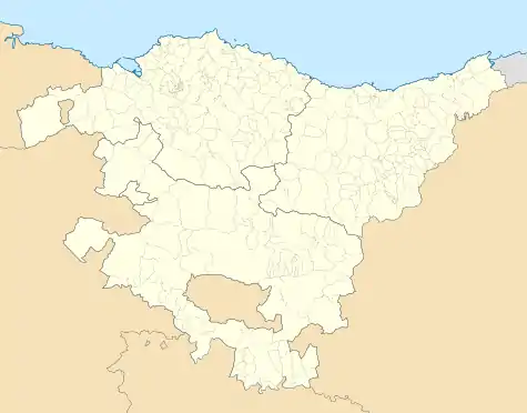 Berango Location of Berango within the Basque Country | |
| Coordinates: 43°21′54″N 2°59′24″W | |
| Country | Spain |
| Autonomous community | Basque Country |
| Province | Biscay |
| Comarca | Greater Bilbao |
| Government | |
| • Mayor | María Isabel Landa Gaubeka (Basque Nationalist Party) |
| Area | |
| • Total | 8.9 km2 (3.4 sq mi) |
| Elevation | 31 m (102 ft) |
| Population (2018)[1] | |
| • Total | 7,130 |
| • Density | 800/km2 (2,100/sq mi) |
| Demonym(s) | Basque: berangotarra |
| Time zone | UTC+1 (CET) |
| • Summer (DST) | UTC+2 (CEST) |
| Postal code | 48640 |
| Website | Official website |
Geographical Location
Berango is confined by Sopelana in the north, with Urduliz in the northeast, with Erandio in southeast, and with Guetxo to the western. In this region there are some cholines that stand out such as Munarrikolanda, Saiherri and Agirremendi mountains. The Gobela river passes through the municipality and disgorges in the Bahía de El Abra. Moreover, Berango receives Larrañazubi's streams and several natural fountains.
References
- Municipal Register of Spain 2018. National Statistics Institute.
External links
Municipalities in Biscay
| Authority control |
|---|
This article is issued from Wikipedia. The text is licensed under Creative Commons - Attribution - Sharealike. Additional terms may apply for the media files.